Northumberland County is a county in the Commonwealth of Pennsylvania. It is part of Northeastern Pennsylvania. As of the 2020 census, the population was 91,647. Its county seat is Sunbury.

Montour County is a county in the Commonwealth of Pennsylvania. It is located in Northeastern Pennsylvania. As of the 2020 census, the population was 18,136. Its county seat is Danville. The county is named for Andrew Montour, a prominent Métis interpreter who served with George Washington during the French and Indian War. It encompasses 132 sq mi, making it the smallest county by land area in the state.

Muncy Township is a township in Lycoming County, Pennsylvania, United States. The population was 1,177 at the 2020 census. It is part of the Williamsport Metropolitan Statistical Area.

Washingtonville is a borough in Montour County, Pennsylvania, United States. The population was 200 at the 2020 census. It is part of the Bloomsburg-Berwick micropolitan area.

The West Branch Susquehanna River is one of the two principal branches, along with the North Branch, of the Susquehanna River in the Northeastern United States. The North Branch, which rises in upstate New York, is generally regarded as the extension of the main branch, with the shorter West Branch being its principal tributary.
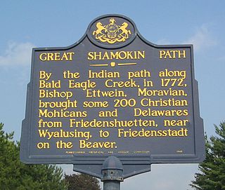
The Great Shamokin Path was a major Native American trail in the U.S. State of Pennsylvania that ran from the native village of Shamokin along the left bank of the West Branch Susquehanna River north and then west to the Great Island. There it left the river and continued further west to Chinklacamoose and finally Kittanning on the Allegheny River.

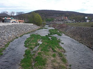
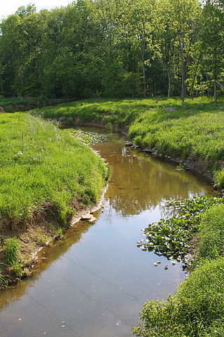
Chillisquaque Creek is a tributary of the West Branch Susquehanna River in Montour County and Northumberland County, in Pennsylvania, in the United States. It is approximately 20.2 miles (32.5 km) long and flows through Derry Township, Washingtonville, and Liberty Township in Montour County and East Chillisquaque Township and West Chillisquaque Township in Northumberland County. The watershed of the creek has an area of 112 square miles (290 km2). Agricultural impacts have caused most of the streams in the watershed of the creek to be impaired. Causes of impairment include sedimentation/siltation and habitat alteration. The average annual discharge of the creek between 1980 and 2014 ranged from 48.2 to 146.0 cubic feet per second. Its watershed mainly consists of rolling agricultural land. The creek's channel flows through rock formations consisting of sandstone and shale. It is a warmwater stream.

The West Branch Susquehanna Valley of central Pennsylvania, United States, in the Ridge-and-valley Appalachians, is the low-lying area draining into the West Branch Susquehanna River southeast of the Allegheny Front, northeast of the Bald Eagle Valley, southwest of the Wyoming Valley and north of the water gap formed between Shamokin Mountain and Montour Ridge.

The Big Runaway was a mass evacuation in June and July 1778 of settlers from the frontier areas of north central Pennsylvania during the American Revolutionary War. A major campaign by Loyalists and Native Americans allied with the British devastated the small communities on the northern and western branches of the Susquehanna River, prompting local militia leaders to order the evacuation. Most of the settlers relocated to Fort Augusta at modern-day Sunbury at the confluence of the North and West Branches of the Susquehanna River, while their abandoned houses and farms were all burnt.
Fort Antes was a stockade surrounding the home of Colonel John Henry Antes, built circa 1778 in Revolutionary Pennsylvania in the United States. The fort was built under the direction of Colonel Antes, who was a member of the Pennsylvania militia. It was on the east side of Antes Creek, overlooking and on the left bank of the West Branch Susquehanna River on a plateau in Nippenose Township south of modern day Jersey Shore in western Lycoming County. The local militia held the fort for a short period of time until it was ordered to abandon Fort Antes during the Big Runaway by Colonel Samuel Hunter. Despite being abandoned and attempts by the attacking British forces to burn it down, Fort Antes was one of only two structures in the valley to survive the Big Runaway.

Pennsylvania Route 405 (PA 405) is a 35.124-mile-long (56.527 km) state highway that runs in the north-central part of the U.S. state of Pennsylvania. The southern terminus of PA 61 in Sunbury. The route heads across the Susquehanna River to Northumberland and northward along the West Branch Susquehanna River through Milton, Watsontown and Muncy until entering Hughesville, where it terminates at an intersection with U.S. Route 220 (US 220).
The Susquehanna, Bloomsburg, and Berwick Railroad, also known as the SB&B Railroad or the Weak and Weary Railroad, which referred to the fact that it was not a financial success, was a railroad in northeastern Pennsylvania until 1918. The route ran from Watsontown, Pennsylvania to Berwick, Pennsylvania. The railroad was 39.22 miles long, with 3.51 miles of branches, totaling 42.83 miles. The railroad was also known as the "Sweet By and By". Trains typically ran along the railroad six days a week. What remains of it is currently a subsidiary of the Pennsylvania Railroad Company.

Major Moses Van Campen (1757–1849) was a soldier during the American Revolutionary War. He was a prominent figure in Pennsylvania and parts of New York. His primary involvement in the Revolutionary War was in fighting against hostile Native American tribes. He began work as a soldier in 1775 and retired from military service in 1783. Van Campen was familiar with Native American methods of warfare. He also participated in the Sullivan Expedition in 1779.

West Branch Chillisquaque Creek is a tributary of Chillisquaque Creek. Its watershed spans parts of Northumberland, Montour, Lycoming, and Columbia counties in Pennsylvania. West Branch Chillisquaque Creek is about five miles long. The creek is home to a number of tree species and herb species. There are also five main types of rock formations and four main types of soil in the creek's watershed.
Mahoning Creek is a tributary of the Susquehanna River in Columbia County and Montour County, in Pennsylvania, in the United States. It is approximately 10.6 miles (17.1 km) long and flows through Madison Township in Columbia County and West Hemlock Township, Derry Township, Valley Township, Mahoning Township, and Danville in Montour County. The watershed of the creek has an area of 39.6 square miles (103 km2). Its tributaries include Kase Run, Mauses Creek, and Sechler Run. Mahoning Creek is designated as a Trout-Stocking Fishery and a Migratory Fishery for part of its length and as a Warmwater Fishery and a Migratory Fishery for the remainder.
Warrior Run is a tributary of the West Branch Susquehanna River in Northumberland County, Pennsylvania, in the United States. It is 9.5 miles (15.3 km) in length. It has a watershed area of 21.6 square miles and the watershed is in Northumberland and Lycoming Counties. The main soil series in the watershed is the Berks-Weikert-Bedington series and the main land uses are agriculture and forest. The communities of Watsontown, Turbotville, and McEwensville are all in or near the watershed. The Warrior Run watershed was inhabited by Europeans in the early 1770s. Several mills and forts were built along it.

East Branch Chillisquaque Creek is a tributary of Chillisquaque Creek in Columbia County and Montour County in Pennsylvania, United States. It is approximately 6.2 miles (10.0 km) long and flows through Madison Township, Columbia County and Derry Township, Montour County. At its mouth, it combines with Middle Branch Chillisquaque Creek to form Chillisquaque Creek. White Hall Creek is a tributary of East Branch Chillisquaque Creek. The creek's watershed has an area of 9.75 square miles (25.3 km2). It is situated over sandstone and shale. The main land uses in the watershed include forested land and agricultural land, although there are some areas of wetlands and open water as well.
Mud Creek is a tributary of Chillisquaque Creek in Columbia County and Montour County in Pennsylvania, in the United States. It is approximately 8.3 miles (13.4 km) long and flows through Madison Township, Columbia County and Derry Township, Montour County. The main tributaries of the creek are unnamed tributaries. The creek's watershed has an area of 17.70 square miles and is in West Hemlock Township, Montour County as well as the two townships it flows through. The watershed is mostly agricultural and forested and the main developed areas are Washingtonville and Jerseytown.

Lake Chillisquaque is a lake and reservoir in Montour County, Pennsylvania, in the United States. It has a surface area of 165 acres. The lake is situated on Middle Branch Chillisquaque Creek, which it is named after. Nearby communities include Danville and Washingtonville. The lake has an elevation of 567 feet (173 m) above sea level and is up to 40 feet (12 m) deep. It has several coves, including Goose Cove, Heron Cove, and Jellyfish Cove. The lake is dammed on its southern side by the Lake Chillisquaque Dam, which is 2,000 feet (610 m) long and 54 feet (16 m) high. The metals with the highest concentrations are calcium and iron. Nonmetals such as nitrogen and phosphorus are also found in the lake. It experiences agricultural runoff as well.
