The Creek War, was a regional conflict between opposing Native American factions, European powers, and the United States during the early 19th century. The Creek War began as a conflict within the tribes of the Muscogee, but the United States quickly became involved. British traders and Spanish colonial officials in Florida supplied the Red Sticks with weapons and equipment due to their shared interest in preventing the expansion of the United States into regions under their control.

John Williams was an American lawyer, soldier, and statesman, operating primarily out of Knoxville, Tennessee, in the first part of the 19th century. He represented Tennessee in the United States Senate from 1815 to 1823, when he lost reelection to Andrew Jackson. Williams also served as colonel of the 39th U.S. Infantry Regiment during the Creek Wars, and played a key role in Jackson's victory at the Battle of Horseshoe Bend in 1814.
Red Sticks —the name deriving from the red-painted war clubs of some Native American Creek—refers to an early 19th century traditionalist faction of Muscogee Creek people in the Southeastern United States. Made up mostly of Creek of the Upper Towns that supported traditional leadership and culture, as well as the preservation of communal land for cultivation and hunting, the Red Sticks arose at a time of increasing pressure on Creek territory by European American settlers. Creek of the Lower Towns were closer to the settlers, had more mixed-race families, and had already been forced to make land cessions to the Americans. In this context, the Red Sticks led a resistance movement against European American encroachment and assimilation, tensions that culminated in the outbreak of the Creek War in 1813. Initially a civil war among the Creek, the conflict drew in United States state forces while the nation was already engaged in the War of 1812 against the British.
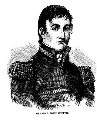
John R. Coffee was an American planter of Irish descent, and a state militia brigadier general in Tennessee. He commanded troops under General Andrew Jackson during the Creek Wars (1813–14) and during the Battle of New Orleans in the War of 1812.
James White was an American pioneer and soldier who founded Knoxville, Tennessee, in the early 1790s. Born in Rowan County, North Carolina, White served as a captain in the county's militia during the American Revolutionary War. In 1783, he led an expedition into the upper Tennessee Valley, where he discovered the future site of Knoxville. White served in various official capacities with the failed State of Franklin (1784–1788) before building James White's Fort in 1786. The fort was chosen as the capital of the Southwest Territory in 1790, and White donated the land for a permanent city, Knoxville, in 1791. He represented Knox County at Tennessee's constitutional convention in 1796. During the Creek War (1813), White served as a brigadier general in the Tennessee militia.

The Fort Mims massacre took place on August 30, 1813, during the Creek War, when a force of Creek Indians belonging to the Red Sticks faction, under the command of head warriors Peter McQueen and William Weatherford, stormed the fort and defeated the militia garrison. Afterward, a massacre ensued and almost all of the remaining mixed Creek, white settlers, and militia at Fort Mims were killed. The fort was a stockade with a blockhouse surrounding the house and outbuildings of the settler Samuel Mims, located about 35 miles directly north of present-day Mobile, Alabama.

John Alexander Cocke was an American politician and soldier who represented Tennessee's 2nd district in the United States House of Representatives from 1819 to 1827. He also served several terms in the Tennessee Senate and the Tennessee House of Representatives, and was Speaker of the latter for two sessions. During the Creek War, Cocke commanded the Eastern Division of the Tennessee militia.

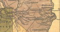
Fort Toulouse and Fort Jackson are two forts that shared the same site at the fork of the Coosa River and the Tallapoosa River, near Wetumpka, Alabama.

Fort Williams was a supply depot built in early 1814 in preparation for the Battle of Horseshoe Bend. It was located in Alabama on the southeast shore where Cedar Creek meets the Coosa River, near Talladega Springs.

Fort Strother was a stockade fort at Ten Islands in the Mississippi Territory, in what is today St. Clair County, Alabama. It was located on a bluff of the Coosa River, near the modern Neely Henry Dam in Ragland, Alabama. The fort was built by General Andrew Jackson and several thousand militiamen in November 1813, during the Creek War and was named for Captain John Strother, Jackson's chief cartographer.

Fort Claiborne was a stockade fort built in 1813 in present-day Monroe County, Alabama during the Creek War.

Fort Bainbridge was an earthen fort located along the Federal Road on what is today the county line between Macon and Russell counties in Alabama. Fort Bainbridge was located twenty-five miles west of Fort Mitchell.

Milstead, also known as Cowles or Cowles Station, is an unincorporated community in Macon County, Alabama, United States.
Fort Armstrong was a stockade fort built in present-day Cherokee County, Alabama during the Creek War. The fort was built to protect the surrounding area from attacks by Red Stick warriors but was also used as a staging area and supply depot in preparation for further military action against the Red Sticks.

Fort Hampton was a collection of log buildings and stables built in present-day Limestone County, Alabama, on a hill near the Elk River. It was named for Brigadier General Wade Hampton by Alexander Smyth, and once complete in the winter of 1810 both men visited the site. The fort was originally built to deter Americans from settling in Chickasaw territory, then was garrisoned during the War of 1812. Later, it was used for United States governmental functions prior to being abandoned.

Fort Hull was an earthen fort built in present-day Macon County, Alabama in 1814 during the Creek War. After the start of hostilities, the United States decided to mount an attack on Creek territory from three directions. The column advancing west from Georgia built Fort Mitchell and then clashed with the Creeks. After a pause in operations, the column from Georgia continued its march and built Fort Hull. The fort was used as a supply point and was soon abandoned after the end of the Creek War.
Fort Montgomery was a stockade fort built in August 1814 in present-day Baldwin County, Alabama, during the Creek War, which was part of the larger War of 1812. The fort was built by the United States military in response to attacks by Creek warriors on encroaching American settlers and in preparation for further military action in the War of 1812. Fort Montgomery continued to be used for military purposes but in less than a decade was abandoned. Nothing exists at the site today.
Fort Pierce, was two separate stockade forts built in 1813 in present-day Baldwin County, Alabama, during the Creek War, which was part of the larger War of 1812. The fort was originally built by settlers in the Mississippi Territory to protect themselves from attacks by Creek warriors. A new fort of the same name was then built by the United States military in preparation for further action in the War of 1812, but the fort was essentially abandoned within a few years. Nothing exists at the site today.