Related Research Articles

Wantagh is a hamlet and census-designated place (CDP) in the Town of Hempstead in Nassau County, on Long Island, New York, United States. The population was 18,871 at the time of the 2010 census.

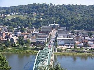
Elizabeth is a borough in Allegheny County, Pennsylvania, on the east bank of the Monongahela River, where Pennsylvania Route 51 crosses, 15 miles (24 km) upstream (south) of Pittsburgh and close to the county line. The population was 1,493 at the 2010 census. The borough of Elizabeth is entirely contained within the 15037 USPS ZIP code. The local school district is the Elizabeth Forward School District. The borough is home to neighborhoods Walker Heights and Town Hill. Elizabeth Borough is the birthplace of Town Hill Hockey established in 1978.
Kittanning is a borough and the county seat of Armstrong County in the U.S. state of Pennsylvania. It is situated 44 miles (71 km) northeast of Pittsburgh, along the east bank of the Allegheny River.

Perryopolis is a borough in Fayette County, Pennsylvania, United States, part of the Pittsburgh metropolitan area. The population was 1,784 at the 2010 census.

Claysville is a borough in Washington County, Pennsylvania, United States and part of the Pittsburgh metropolitan area since 1950. The population was 829 at the 2010 census. Claysville Elementary School, part of the McGuffey School District is located in Claysville. It is the birthplace of Benjamin Franklin Jones of the Jones and Laughlin Steel Company.

Hempfield Township is a township in Westmoreland County, Pennsylvania, United States. The population was 43,241 at the 2010 census, making it the second largest suburb in the Pittsburgh Metropolitan Area by population. Its name is taken from Hempfield in Lancaster County, which was formed in 1729 and is named after the hemp fields in the area.
Ligonier is a borough in Westmoreland County, Pennsylvania, United States. The population was 1,573 at the 2010 census. Ligonier was settled in the 1760s. The borough is well known for nearby Idlewild Park, one of the oldest amusement parks in the country; and nearby Seven Springs Mountain Resort. Another tourist attraction is Fort Ligonier Days, a parade and craft market that takes place every fall over the course of three days, and the Ligonier Country Market in the summer months. Ligonier is part of the Pittsburgh Metropolitan Statistical Area.

The Jones and Laughlin Steel Company began as the American Iron Company, founded in 1852 by Bernard Lauth and B. F. Jones, a few miles south of Pittsburgh along the Monongahela River. Lauth's interest was bought in 1854 by James Laughlin. The first firm to bear the name of Jones and Laughlin was organized in 1861 and headquartered at Third & Ross in downtown Pittsburgh.

The South Side Flats is a neighborhood in Pittsburgh, Pennsylvania's South Side area. It is located just south of the Monongahela River. The neighborhood has one of the City of Pittsburgh's largest concentrations of 19th-century homes, which has prompted outsiders to call the neighborhood the City's Georgetown. It includes many bars and restaurants as well as residences. The main throughway in the South Side Flats is East Carson Street. The street is home to a significant portion of Pittsburgh's nightlife.

Wood National Cemetery is a United States National Cemetery located in Milwaukee, Wisconsin. It is one of two National Cemeteries in Wisconsin. It encompasses 50.1 acres (20.3 ha), and as of 2021, it had over 40,000 interments. It is closed to new interments.
Braddock's Field is a historic battlefield on the banks of the Monongahela River, at Braddock, Pennsylvania, near the junction of Turtle Creek, about nine miles southeast of the "Forks of the Ohio" in Pittsburgh, Pennsylvania. Here, in 1755, was fought the Battle of the Monongahela which ended the Braddock Expedition.
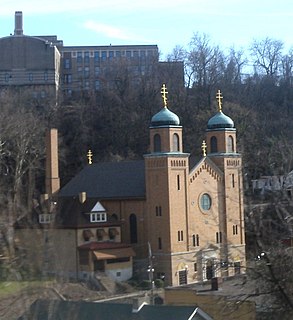
St. John Chrysostom Byzantine Catholic Church is a historic Eastern Catholic church in Pittsburgh, Pennsylvania, United States. It is located in the neighborhood of Four Mile Run, which is an isolated section of Greenfield at the bottom of Junction Hollow. Its address is 506 Saline Street.

Soldiers and Sailors Memorial Hall and Museum is a National Register of Historic Places landmark in Pittsburgh, Pennsylvania, United States. It is the largest memorial in the United States dedicated solely to honoring all branches of military veterans and service personnel.
Fort Laughlin was a Civil War redoubt, built in 1863 for the defense of Pittsburgh by the employees of Jones and Laughlin Iron Works, and named for James H. Laughlin. It was also known as Fort McKinley or Fort Ormsby. It was a circular earthwork on Ormsby's Hill, now part of Arlington Park on Arlington Avenue.
Fort Robert Smalls was a Civil War redoubt built by free Blacks for the defense of Pittsburgh in 1863.
Becks Run is a tributary of the Monongahela River. As an urban stream, it is heavily polluted, receiving combined sewer outflow from Carrick (Pittsburgh) and Mount Oliver, Pennsylvania. There is a waterfall on a tributary, just downstream from a slate dump, near the intersection of Wagner Avenue and Mountain Avenue. There were coal mines along the stream, including Becks Run #2, owned by the estate of James H. Hays, served by an incline and the H.B. Hays and Brothers Coal Railroad. Other mines at various times were operated by the Birmingham Coal Company, H.G. Burghman, Jones & Laughlin, and the Monongahela River Consolidated Coal and Coke Company.

Pittsburgh, Pennsylvania was a thriving and important city during the American Civil War, and provided a significant source of personnel, war materiel, armament, ammunition, and supplies to the Union Army. Situated at the confluence of the Monongahela, Allegheny and Ohio rivers, Pittsburgh was an important transportation hub for both riverine and rail transport, as well as overland via its system of roads.
Conrad Feger Jackson was a businessman and soldier from the state of Pennsylvania. He served as a brigadier general in the Union Army during the American Civil War and was killed in action during the Battle of Fredericksburg.

The Civil War Defenses of Washington were a group of Union Army fortifications that protected the federal capital city, Washington, D.C., from invasion by the Confederate States Army during the American Civil War. The sites of some of these fortifications are within a collection of National Park Service (NPS) properties that the National Register of Historic Places identifies as the Fort Circle. The sites of other such fortifications in the area have become parts of state, county or city parks or are located on privately owned properties. A trail connecting the sites is part of the Potomac Heritage Trail.
Ellsworth Avenue is located in the Shadyside neighborhood of Pittsburgh, Pennsylvania. It is mostly a commercial street that has locally owned businesses, galleries, restaurants, and bars. It runs southwest-northeast, parallel to Walnut Street, another commercial street, and is bounded by Shady Avenue to the east and South Neville Street to the west. Ellsworth Avenue is one of Shadyside's three business districts, along with South Highland Avenue and Walnut Street.
References
- ↑ "Greater Pittsburgh Area" . Retrieved 4 July 2008.
- ↑ Lambing, Andrew Arnold (1880). A history of the Catholic church in the dioceses of Pittsburg and Allegheny. New York: Benzinger. pp. 158–160. OCLC 1626049 . Retrieved 2 January 2011.
- ↑ Moody, Chuck (2005). "South Pittsburgh church closings announced". Pittsburgh Catholic . Archived from the original on 2011-07-15. Retrieved 2008-08-30.
- ↑ Fox, Arthur B. (2002). Pittsburgh During the American Civil War, 1860-1865. ISBN 0-9760563-0-5.