Related Research Articles

Fort MacArthur is a former United States Army installation in San Pedro, Los Angeles, California. A small section remains in military use by the United States Air Force as a housing and administrative annex of Los Angeles Air Force Base. The fort is named after Lieutenant General Arthur MacArthur. His son, Douglas MacArthur, would later command American forces in the Pacific during World War II.

Fort Fisher Air Force Station was a United States Air Force installation located on the Atlantic coast 0.8 miles (1.3 km) southwest of Kure Beach, North Carolina. Its primary mission was as a radar complex. It was closed on 30 June 1988 by the Air Force, and turned over to the Federal Aviation Administration (FAA).
Ground Equipment Facility J-33 is a Federal Aviation Administration (FAA) radar station of the Joint Surveillance System's Western Air Defense Sector (WADS) with an Air Route Surveillance Radar (ARSR-4). The facility was previously a USAF general surveillance radar station during the Cold War.

Gibbsboro Air Force Station is a closed United States Air Force General Surveillance Radar station. It is located 1.1 miles (1.8 km) south-southeast of Gibbsboro, in Camden County, New Jersey, United States. It was closed in 1994 by the Air Force, and turned over to the Federal Aviation Administration (FAA).

Ground Equipment Facility QRC is an FAA radar station that was part of a Cold War SAGE radar station for aircraft control and warning "from Massachusetts to southern Virginia, and as far out to sea as possible." Benton AFS was also the first operational "regional data processing center" for the GE 477L Nuclear Detection and Reporting System.
The SAGE radar stations of Air Defense Command were the military installations operated by USAF squadrons using the 1st automated air defense environment and networked by the SAGE System, a computer network. Most of the radar stations used the Burroughs AN/FST-2 Coordinate Data Transmitting Set (CDTS) to automate the operator environment and provide radar tracks to sector command posts at SAGE Direction Centers (DCs), e.g., the Malmstrom Z-124 radar station was co-located with DC-20. The sector/division radar stations were networked by DCs and Manual Control Centers to provide command, control, and coordination for ground-controlled interception of enemy aircraft by interceptors such as the F-106 developed to work with the SAGE System.
Palermo Air Force Station is a closed United States Air Force (USAF) General Surveillance Radar station. It was located in Palermo, New Jersey, 4.8 miles (7.7 km) north of Sea Isle City, in Cape May County, New Jersey, United States. It was closed in 1970.
Manassas Air Force Station is a closed United States Air Force General Surveillance Radar station. It is located 7.4 miles (11.9 km) west of Dale City, Virginia. It was closed in 1965.
Brookfield Air Force Station is a closed United States Air Force General Surveillance Radar station. It is located 1.1 miles (1.8 km) south-southeast of Brookfield, Ohio. It was closed in 1959.
Oakdale Air Force Station is a United States Air Force General Surveillance Radar station. It is located 1.3 miles (2.1 km) east of the Pittsburgh suburb of Oakdale, Pennsylvania. It was closed in 1969.

Belleville Air Force Station is a closed United States Air Force General Surveillance Radar station. It is located 2 miles (3.2 km) southeast of Belleville, Illinois. It was closed in 1968.

Duncanville Air Force Station is a closed United States Air Force General Surveillance Radar station. It is located on the east side of Duncanville, Texas. It was closed in 1964.
Olathe Air Force Station is a former United States Air Force radar station that was located in Gardner, Kansas. It was located next to Naval Air Station Olathe, now the grounds of New Century AirCenter.

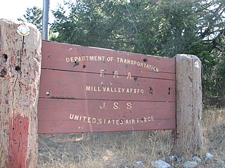
Ground Equipment Facility J-31 is a Joint Surveillance System radar site of the Western Air Defense Sector (WADS) and the Federal Aviation Administration's air traffic control radar network for the Los Angeles Air Route Traffic Control Center. The facility's Air Route Surveillance Radar Model 1E with an ATCBI-6 beacon interrogator system are operated by the FAA and provide sector data to North American Aerospace Defense Command. The site provided Semi-Automatic Ground Environment data to the 1959-66 Norton AFB Direction Center for the USAF Los Angeles Air Defense Sector. The site also provided Project Nike data to the 1960-74 Fort MacArthur Direction Center ~3 mi (4.8 km) away for the smaller US Army Los Angeles Defense Area—as well as gap-filler radar coverage for the 1963-74 Integrated Fire Control area of Malibu Nike battery LA-78 on San Vicente Mountain.
Fort Lawton Air Force Station is a closed United States Air Force General Surveillance Radar station. It is located on Fort Lawton in the Magnolia neighborhood of northwest Seattle, Washington. The Air Force inactivated its unit in 1963; while the site remained under Army control until 1974. Today the Federal Aviation Administration (FAA) operates the site as part of the Joint Surveillance System (JSS).
The Martin AN/FSG-1 Antiaircraft Defense System, better known as Missile Master, was an electronic fire distribution center to computerize Cold War air defense (AD) command posts from manual plotting board operations to automated command and control of remote surface-to-air missile (SAM) launch batteries. The 10 United States Army C3 systems used radar netting ("electronic umbrella") at Missile Master military installations for coordinating ground-controlled interception by Nike and MIM-23 Hawk missiles. The vacuum tube fire control logic reduced the time to designate the appropriate missile battery to launch if an enemy target had intruded into a defense area where an AN/FSG-1 system was deployed.

Missile Master was a US Army surface-to-air missile control complex/facility. It controlled Project Nike missiles. Virtually all Missile Masters had a bunker housing the Martin AN/FSG-1 Antiaircraft Defense System, as well as additional structures for "an AN/FPS-33 defense acquisition radar (DAR) or similar radar, two height-finder radars," and identification friend or foe secondary radar. The radars, along with Automated Data Links (ADL) from remote Nike firing units, provided data into the AN/FSG-1 tracking subsystem with the DAR providing surveillance coverage to about 200 mi (320 km).
The Arlington Heights Army Air Defense Site was a Project Nike Missile Master site near Chicago, Illinois. It operated from 1960 until 1968.

The Fort Heath radar station was a USAF radar site and US Army Missile Master installation of the joint-use site system (JUSS) for North American Air Defense at a former coastal defense site. The Cold War radar station had 2 USAF AN/FPS-6B height finding radars, 2 Army AN/FPS-6A height finders, an FAA ARSR-1 radar emplaced 1958-9, and an Army nuclear bunker. Arctic Towers were the pedestals for the FPS antennas and radomes, while the Air Route Surveillance Radar was on a 50-foot extension temperate tower adjacent to the Federal Aviation Administration building.
NORAD Control Centers (NCCs) were Cold War "joint direction centers" for command, control, and coordination of ground-controlled interception by both USAF Air Defense Command (ADC) and Army Air Defense Command (ARADCOM). The Joint Manual Steering Group was "formed by the Army and Air Force in July 1957 to support…collocation" of USAF Air Defense Direction Centers and Army Air Defense Command Posts, which began after a January 28, 1958, ADC/ARADCOM meeting with NORAD to "collocate the Fairchild-Geiger facilities" Army contracts for 5 NCCs had been let by August 17, 1958, after 1956 DoD approval for collocation of interim "pre-SAGE semiautomatic intercept systems" and radar squadrons at 10 planned Army Missile Master AADCPs
References
- ↑ Bender, Donald E (December 1999). "The Pedricktown Missile Master Site, 1960-1966". Quarterly Newsletter. Salem County Historical Society. Archived from the original (FDU.edu website) on 2011-08-06. Retrieved 2011-09-06.
- ↑ Winkler, David F (1997). Searching the skies: the legacy of the United States Cold War defense radar program. Prepared for United States Air Force Headquarters Air Combat Command.
- ↑ "Missile Master News Release-1". United States Army. December 5, 1957. Archived from the original (transcript) on March 23, 2012. Retrieved 2011-09-03.
- ↑ Cole, Merle T. "Army Air Defense Installations in Anne Arundel County: 1950-1975". Nike Missiles. FTMeade.Army.mil. Archived from the original on 2012-03-23. Retrieved 2011-09-15.
- ↑ Cornett, Lloyd H; Johnson, Mildred W. A Handbook of Aerospace Defense Organization 1946 - 1980. Peterson Air Force Base: Office of History, Aerospace Defense Center.
- ↑ "Information for Fort Meade, MD". Radomes.org. Retrieved 2011-09-02.