Fort Oranje (Sint Eustatius)

Last updated
Fort Oranje
Oranjestad, Sint Eustatius
Fort Oranje from the Slave Path - panoramio.jpg
View of Fort Oranje
Caribbean location map.svg
Red pog.svg
Fort Oranje
Coordinates 17°28′55″N62°59′11″W / 17.4820°N 62.9865°W / 17.4820; -62.9865
Type Fortification
Site information
Open to
the public
Yes
Site history
Built1636
In useNo


Fort Oranje is a historic fortress located in Sint Eustatius in the Dutch Caribbean. It is located in Oranjestad, the island's capital, on a cliff overlooking Oranje Bay. [1] It was named after the House of Oranje, the royal family of the Netherlands. [2]

Contents

The fort was built by the Dutch in 1636, at the location of a previous fort built by the French in 1629. [3] [4] Its construction was commissioned by the Dutch West India Company. [5] [6] Like the island, the fort changed‌ ‌hands‌ several times ‌between‌ ‌the‌ ‌Dutch,‌ ‌English‌ ‌and‌ ‌French‌. [7] It was rebuilt and renovated several times during the 17th and 18th centuries. [3] [4] Today, the fort is one of many protected buildings in Sint Eustatius.

History

The first European settlers on St. Eustatius were the French, who arrived from 1625 and 1629. [8] They came from nearby nearby St. Kitts. In 1629, the French built a wooden fortress at the present-day location of Fort Oranje. [3] [4] The French abandoned the fort and the island due to lack of clean drinking water. [9] [10]

In 1636, Dutch settlers from Zeeland took possession of the then unoccupied St. Eustatius. [11] [12] With a commission from the Dutch West India Company, they constructed a new fort at the location where they found remains of the French fort. [5] [6] They named the new fortress Fort Oranje after the House of Oranje, the Dutch royal family. [2]

The original Fort Oranje for square-shaped, with four bastions, a courtyard, and 16 mounted cannons. [3] Historians presume it was wooden, as it was burned by the Dutch in 1673 and rebuilt by the English later in the year. [4] [3] In 1689, the French took over the island and fort, and carried out additional renovations of the fort. [3] [4] They reinforced the walls with doubled palisades and built a dry moat around the fort. [13] Beginning in 1737, the fort underwent a series of renovations by the Dutch via the work of enslaved Africans. [3] [4]

Until 1846, Fort Oranje served as a garrison for army infantry and artillery. After being empty for many years, the fortress was refurbished and furnished as an administrative center to house the lieutenant governor's office, government services, and the prison.

After partial fire destruction in 1990, [14] [15] the fort was restored in the late 1990s. [16] Since then, the offices of the public prosecutor's office, the planning department, and the tourist office have been kept here. [17]

The "First Salute"

Painting (by Phillips Melville) depicting Andrew Doria receiving salute from the Fort Oranje. Andrew Doria NH 85510-KN.jpg
Painting (by Phillips Melville) depicting Andrew Doria receiving salute from the Fort Oranje.

It was from Fort Oranje that the famous First Salute was fired on November 16, 1776. Dutch governor Johannes de Graaff had the fort's cannons return‌ ‌a‌ ‌salute‌‌ of 11 shots ‌to‌ ‌the USS Andrew Doria , [18] which had entered the island's harbor. The ship was flying the new Grand Union Flag, [19] as the American thirteen colonies had just declared their independence from the British. Many interpreted the salute as the first recognition by a foreign power of America's independence. [20] It was one of the reasons for the Fourth Anglo-Dutch War (1780-1784). [21] [22]

In 1939, President Franklin Delano Roosevelt offered a plaque in recognition of the First Salute. [3] [23] The plaque was placed against the flagpole in the fort square. [23]

Preservation

Between February 2019 to May 2020, the cliff supporting Fort Oranje underwent a stabilization project to help increase the cliff's stability and stop erosion. [24] The project involved the placement of 2,800 anchors, 7,400 square meters of canvas, and more than 15,000 square meters of mesh. [24]

Related Research Articles

<span class="mw-page-title-main">Netherlands Antilles</span> 1954–2010 Caribbean constituent country of the Netherlands

The Netherlands Antilles was a constituent country of the Kingdom of the Netherlands. The country consisted of several island territories located in the Caribbean Sea. The islands were also informally known as the Dutch Antilles. The country came into being in 1954 as the autonomous successor of the Dutch colony of Curaçao and Dependencies. The Antilles were dissolved in 2010. The Dutch colony of Surinam, although relatively close by on the continent of South America, did not become part of the Netherlands Antilles but became a separate autonomous country in 1954. All the island territories that belonged to the Netherlands Antilles remain part of the kingdom today, although the legal status of each differs. As a group they are still commonly called the Dutch Caribbean, regardless of their legal status. People from this former territory continue to be called Antilleans in the Netherlands.

<span class="mw-page-title-main">Saba (island)</span> Dutch Caribbean island

Saba is a Caribbean island and the smallest special municipality of the Netherlands. It consists largely of the active volcano Mount Scenery, which at 887 metres (2,910 ft) is the highest point of the entire Kingdom of the Netherlands. The island lies in the northern Leeward Islands portion of the West Indies, southeast of the Virgin Islands. Together with Bonaire and Sint Eustatius it forms the BES islands, also known as the Caribbean Netherlands.

<span class="mw-page-title-main">Sint Eustatius</span> Dutch Caribbean island

Sint Eustatius, known locally as Statia, is an island in the Caribbean. It is a special municipality of the Netherlands.

<span class="mw-page-title-main">Oranjestad, Sint Eustatius</span> Town in Sint Eustatius, Netherlands

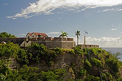
Oranjestad is a small town of 1,038 inhabitants; it is the capital and largest town of the island of Sint Eustatius in the Caribbean Netherlands. It’s not to be confused with the far larger Oranjestad in Aruba.

The Democratic Party is a political party in Sint Eustatius with two seats in the 5-seat island council. In 2011, the party obtained 2 seats in the first elections after Sint Eustatius became part of the Netherlands upon the dissolution of the Netherlands Antilles in 2011. However, their Island Council representative Reuben Merkman left the DP in 2014 and became an independent council member.

<span class="mw-page-title-main">The Quill (volcano)</span>

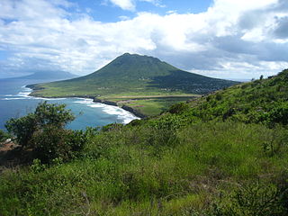
The Quill, also known as Mount Mazinga, is a stratovolcano located on the island of Sint Eustatius in the Caribbean Netherlands. The summit elevation is 601 m (1,972 ft) above sea level. It is also the second highest mountain in the Netherlands.

<span class="mw-page-title-main">Flag of Sint Eustatius</span>

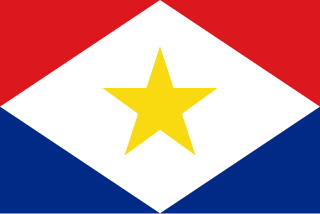
The flag of Caribbean Netherlands island of Sint Eustatius (Statia) consists of a blue field, red fimbriations, and in the center, a white diamond with a silhouette of the island. The flag was designed by Zuwena Suares and adopted on 29 July 2004 to be put into use on 16 November of that year. Since 2010, it has been the official flag of the special municipality of Sint Eustatius.

<span class="mw-page-title-main">F. D. Roosevelt Airport</span> Airport in Sint Eustatius

F. D. Roosevelt Airport is the airport located on the island of Sint Eustatius, Caribbean Netherlands. It was opened as "Golden Rock Airport" in 1946 and renamed for Franklin Delano Roosevelt. As of 2012, the only commercial aircraft that serves the island is the DHC-6 Twin Otter, although the runway can accommodate larger turboprop aircraft and some smaller jets. As of 2023, the largest aircraft type to operate at the airport is the ATR 42.

<span class="mw-page-title-main">Johannes de Graaff</span>

Johannes de Graaff (1729–1813), also referred to as Johannis de Graeff in some documents, was a Dutch Governor of Sint Eustatius, Saba and Sint Maarten in the Netherlands Antilles representing the Dutch West India Company during the difficult time of the American Revolutionary War.

<span class="mw-page-title-main">Caribbean Netherlands</span> Netherlands Caribbean municipalities

The Caribbean Netherlands is a geographic region of the Netherlands located outside of Europe, in the Caribbean, consisting of three so-called special municipalities. These are the islands of Bonaire, Sint Eustatius and Saba, as they are also known in legislation, or the BES islands for short. The islands are officially classified as public bodies in the Netherlands and as overseas territories of the European Union; as such, European Union law does not automatically apply to them.

Fort Orange may refer to:

<span class="mw-page-title-main">Dutch Caribbean</span> Caribbean part of the Kingdom of the Netherlands

The Dutch Caribbean are the New World territories, colonies, and countries of the Dutch Empire and the Kingdom of the Netherlands located in the Caribbean Sea, mainly the northern and southwestern regions of the Lesser Antilles archipelago.

<span class="mw-page-title-main">St. Eustatius Church (Oranjestad)</span> Church in Sint Eustatius, Kingdom of the Netherlands

St. Eustatius Church is a parish of the Catholic Church in Oranjestad, Sint Eustatius, the capital of the Caribbean island of St. Eustatius, in the Dutch Caribbean.

Same-sex marriage has been legal in Bonaire, Sint Eustatius and Saba since 10 October 2012, the effective date of legislation passed by the States General of the Netherlands enabling same-sex couples to marry.

<span class="mw-page-title-main">COVID-19 pandemic in Sint Eustatius</span> Ongoing COVID-19 viral pandemic in Sint Eustatius

The COVID-19 pandemic in Sint Eustatius is part of the ongoing global viral pandemic of coronavirus disease 2019 (COVID-19), which was confirmed to have reached the Dutch Caribbean island of Sint Eustatius on 31 March 2020. On 5 May all cases recovered. The island's first COVID-19 death was recorded on 19 January 2022. The patient died at the St. Maarten Medical Center (SMCC) where they had been transported for treatment according to the press release of the St. Eustatius government.

The Sint Eustatius national football team is the national association football team of the Caribbean island of Sint Eustatius. It is a not member of the Caribbean Football Union, CONCACAF, or FIFA and therefore cannot compete in tournaments sanctioned by these organizations. It is under the auspices of the Statia Football Association.

Claudia Toet is a Dutch politician from The Hague who was appointed Deputy Government Commissioner of the Caribbean island of St. Eustatius, a special public body of the Netherlands, in 2021.

<span class="mw-page-title-main">Godet African Burial Ground</span> Burial ground in the Dutch Caribbean

The Godet African Burial Ground is an unmarked historical burial ground for enslaved African men, women and children located at the southwest coast of Sint Eustatius, Dutch Caribbean. The burial ground was part of the former Godet plantation on the island.

<span class="mw-page-title-main">Golden Rock African Burial Ground</span> Burial ground in the Dutch Caribbean

The Golden Rock African Burial Ground is an unmarked historical burial ground of enslaved African men, women and children located on the premises of the airport on Sint Eustatius, Dutch Caribbean in the ‘Cultuurvlakte’. The burial ground was part of the former Golden Rock plantation on the island.

<span class="mw-page-title-main">Golden Rock (archaeological site)</span> Caribbean archeological site

Golden Rock is the name of an archaeological site in the centre of the island of Sint Eustatius, Dutch Caribbean, named after a nearby former plantation. Golden Rock was the nickname of Sint Eustatius from its prominence as a major colonial trading port in the late 17th and early 18th century. The site contains the remains of a late Saladoid village, an African burial ground, and a village of enslaved Africans.

References

  1. Gilmore, R. G. (2013), Comer, Douglas C. (ed.), "St. Eustatius: The Nexus for Colonial Caribbean Capitalism", The Archaeology of Interdependence: European Involvement in the Development of a Sovereign United States, SpringerBriefs in Archaeology, vol. 1, New York, NY: Springer, pp. 41–60, doi:10.1007/978-1-4614-6028-2_3, ISBN   978-1-4614-6028-2 , retrieved 2023-04-01
  2. 1 2 "Fort Oranje". Statia Tourism. St. Eustatius Tourism Development Foundation. Retrieved 2023-04-01.
  3. 1 2 3 4 5 6 7 8 Hartog, Johannes (1976). History of St. Eustatius. Central U.S.A. Bicentennial Committee of the Netherlands Antilles : distributors, De Witt Stores N.V.
  4. 1 2 3 4 5 6 St. Eustatius Fort Oranje: A Historical Archaeological and Architectural Assessment (PDF) (Report). St. Eustatius Center for Archaeological Research. 2011-07-12. Archived from the original (PDF) on 2023-01-13.
  5. 1 2 Henderson, James (1992). The Caribbean. Cadogan Books. p. 330. ISBN   978-1-56440-003-1.
  6. 1 2 Comer, Douglas C. (2013-01-04). The Archaeology of Interdependence: European Involvement in the Development of a Sovereign United States. Springer Science & Business Media. p. 42. ISBN   978-1-4614-6028-2.
  7. "History: About St. Eustatius". Statia Government. 2020-06-16. Retrieved 2023-04-02.
  8. Benjamins, Herman Daniël; Snelleman, Johannes (1917). Encyclopaedie van Nederlandsch West-Indië . Digital Library for Dutch Literature (in Dutch). Leiden: Martinus Nijhoff Publishers.
  9. Stelten, R.J.G. (2019). "From Golden Rock to Historic Gem: a historical archaeological analysis of the maritime cultural landscape of St. Eustatius, Dutch Caribbean (Doctoral Thesis)". Leiden University Scholarly Publications.
  10. Agency, Netherlands Ministry of Education, Culture and Science Cultural Heritage; UNESCO (2021-03-10). The UNESCO Training Manual for the Protection of the Underwater Cultural Heritage in Latin America and the Caribbean. UNESCO Publishing. p. 12. ISBN   978-92-3-100427-8.{{cite book}}: CS1 maint: multiple names: authors list (link)
  11. The Caribbean: Volumes 1-3. The Caribbean Commission. 1947.{{cite book}}: CS1 maint: date and year (link)
  12. Klooster, Wim (2016-10-19). The Dutch Moment: War, Trade, and Settlement in the Seventeenth-Century Atlantic World. Cornell University Press. ISBN   978-1-5017-0667-7.
  13. Hartog, Johan. De forten, verdedigingswerken en geschutstellingen van Sint Eustatius en Saba: van Pieter van Corselles tot Abraham Heyliger, 1636-1785. Europese bibliotheek, 1997. Print.
  14. Ruigrok, Paul (18 May 2020). "Government commissioner sees a long road ahead for self-governance on Statia". Caribbean Network.
  15. "Vlammen verwoest deel Fort Oranje" [Flames destroyed part of Fort Oranje]. Amigoe (in Dutch). 8 October 1990.
  16. van Ditzhuijzen, Jeannette (30 June 1998). "Rebels fort op Statia wordt hersteld" [Rebel fortress on Statia being restored]. Trouw (in Dutch).
  17. "History Fort Oranje". Public Prosecutor Curacao Sint Maarten BES Islands. 2021-01-15. Retrieved 2023-05-27.
  18. "U.S. Relations With the Netherlands". www.state.gov. Bureau of European and Eurasian Affairs, United States Department of State. 6 September 2022.
  19. "About St. Eustatius: First Salute". Statia Government. 2020-06-16. Retrieved 2023-04-02.
  20. Bartle, Annette (1975-12-07). "Statia's Heritage: Gifts From the Sea". The New York Times. ISSN   0362-4331 . Retrieved 2023-04-01.
  21. Müller, Leos (2019). Neutrality in World History. New York: Taylor & Francis. ISBN   978-1-351-68305-0.
  22. Hellebrand, Walter (2018-10-22). "The First Salute: A unique moment in history". The Daily Herald. Retrieved 2023-05-27.
  23. 1 2 "King and US President are welcome for 'First Salute'". The Daily Herald. 15 October 2018. Retrieved 27 May 2023.
  24. 1 2 "Cliff stabilisation project for Fort Oranje nears completion". The Daily Herald. 2020-05-05. Archived from the original on 2023-04-01.