
Banten is the westernmost province on the island of Java, Indonesia. Its capital city is Serang. The province borders West Java and the Special Capital Region of Jakarta on the east, the Java Sea on the north, the Indian Ocean on the south, and the Sunda Strait on the west. The province covers an area of 9,662.82 km2 (3,730.84 sq mi). It had a population of over 11.9 million in the 2020 census, up from about 10.6 million in 2010. The estimated mid-2021 population was 12.06 million. Formerly part of the province of West Java, Banten was declared a separate province in 2000. The region is the homeland of the Bantenese people, whose culture differs slightly from that of West Java's Sundanese people. The northern half has recently experienced rapid rises in population and urbanization, and the southern half has a more traditional character.

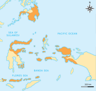
North Maluku is a province of Indonesia. It covers the northern part of the Maluku Islands, bordering the Pacific Ocean to the north, the Halmahera Sea to the east, the Molucca Sea to the west, and the Seram Sea to the south. The provincial capital is Sofifi on the largest island of Halmahera, while the largest city is the island city of Ternate. The population of North Maluku was 1,038,087 in the 2010 census, making it one of the least-populous provinces in Indonesia, but by the 2020 Census the population had risen to 1,282,937, and the official estimate as at mid 2021 was 1,299,177.

Maluku is a province of Indonesia. It comprises the central and southern regions of the Maluku Islands. The main city and capital of Maluku province is Ambon on the small Ambon Island. The land area is 62,946 km2, and the total population of this province at the 2010 census was 1,533,506 people, rising to 1,848,923 at the 2020 Census. The official estimate as at mid 2021 was 1,862,626. Maluku is located in Eastern Indonesia. It is directly adjacent to North Maluku and West Papua in the north, Central Sulawesi, and Southeast Sulawesi in the west, Banda Sea, East Timor and East Nusa Tenggara in the south and Arafura Sea and Papua in the east.

Ternate is a city in the Indonesian province of North Maluku and an island in the Maluku Islands. It was the de facto provincial capital of North Maluku before Sofifi on the nearby coast of Halmahera became the capital in 2010. It is off the west coast of Halmahera, and is composed of eight islands: Ternate, the biggest and main island of the city, and Moti, Hiri, Tifure, Mayau, Makka, Mano, and Gurida. In total, the city has a land area of 162.17 square kilometres and had a total population of 185,705 according to the 2010 census, and 205,001 according to the 2020 census, with a density of 1,264 people per square kilometre. It is the biggest and most densely populated city in the province, is the economic, cultural, and education center of North Maluku, and acts as a hub to neighbouring regions. It was the capital of the Sultanate of Ternate in the 15th and 16th centuries, and fought against the Sultanate of Tidore over control of the spice trade in the Moluccas before becoming a main interest to competing European powers.

Tidore is a city, island, and archipelago in the Maluku Islands of eastern Indonesia, west of the larger island of Halmahera. Part of North Maluku Province, the city includes the island of Tidore together with a large part of Halmahera Island to its east. In the pre-colonial era, the Sultanate of Tidore was a major regional political and economic power, and a fierce rival of nearby Ternate, just to the north.
The Sultanate of Ternate, previously also known as the Kingdom of Gapi is one of the oldest Muslim kingdoms in Indonesia besides Tidore, Jailolo, and Bacan. The Ternate kingdom was established by Momole Cico, the first leader of Ternate, with the title Baab Mashur Malamo, traditionally in 1257. It reached its Golden Age during the reign of Sultan Baabullah (1570–1583) and encompassed most of the eastern part of Indonesia and a part of southern Philippines. Ternate was a major producer of cloves and a regional power from the 15th to 17th centuries.

The Sultanate of Tidore was a sultanate in Southeast Asia, centered on Tidore in the Maluku Islands. It was also known as Duko, its ruler carrying the title Kië ma-kolano. Tidore was a rival of the Sultanate of Ternate for control of the spice trade, and had an important historical role as binding the archipelagic civilizations of Indonesia to the Papuan world.

The Sultanate of Bacan was a state in Maluku Islands, present-day Indonesia that arose with the expansion of the spice trade in late medieval times. It mainly consisted of the Bacan Islands but had periodical influence in Ceram and the Papuan Islands. It fell under the colonial influence of Portugal in the 16th century and the Dutch East India Company (VOC) after 1609. Bacan was one of the four kingdoms of Maluku together with Ternate, Tidore and Jailolo, but tended to be overshadowed by Ternate. After the independence of Indonesia in 1949, the governing functions of the sultan were gradually replaced by a modern administrative structure. However, the sultanate has been revived as a cultural entity in present times.

Fort Rotterdam is a 17th-century fort in Makassar on the island of Sulawesi in Indonesia. It is a Dutch fort built on top of an existing fort of the Gowa Kingdom. The first fort on the site was constructed by the a local sultan in around 1634, to counter Dutch encroachments. The site was ceded to the Dutch under the Treaty of Bongaya, and they completely rebuilt it between 1673 and 1679. It had six bastions and was surrounded by a seven meter high rampart and a two meter deep moat.

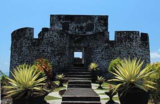
Fort Oranje is a 17th-century Dutch fort on the island of Ternate in Indonesia.
Fort Tolukko is a small fortification on the east coast of Ternate facing Halmahera. It was one of the colonial forts built to control the trade in clove spices, which prior to the eighteenth century were only found in the Maluku Islands. It has been variously occupied by the Portuguese, the native Ternate Sultanate, the Dutch, the British and the Spanish. It was abandoned as a fort in 1864, renovated in 1996, and is now a tourist attraction.

Fort Kalamata is a coastal star fort that was built by the Portuguese on the island of Ternate in Indonesia's Maluku Islands. Formerly known as Benteng Kayu Merah because it is located in Kayu Merah village, Originally the fort was named Santa Lucia, but later it became famous for Fort Kalamata. Kalamata itself comes from the name Pengeran Kalamata, the younger brother of the Sultan of Ternate Madarsyah

Fort Kastela is a ruined Portuguese fortress located at the southwest coast of Ternate. It is famous for being the first colonial fortification constructed in the Spice Islands (Maluku) of Indonesia. Built by the Portuguese in 1522, it is also referred to in different languages as São João Baptista de Ternate or Fortaleza de Ternate (Portuguese), Ciudad del Rosario (Spanish) or Gammalamma. Today it is locally known as Kastella/Kastela.
Mona Lohanda was an Indonesian historian, archivist and academic, as well as a curator of the National Archives of Indonesia. She was a leading authority on the history of Batavia, as well as its Chinese-Indonesian community.

Sultan Saifuddin, also known as Golofino was the eleventh Sultan of Tidore in Maluku islands. Reigning from 1657 to 1687, he left Tidore's old alliance with the Spanish Empire and made treaties with the Dutch East India Company (VOC), which now became hegemonic in Maluku for the next century. Tidore was forced to extirpate the clove trees in its territory and thus ceased to be a spice Sultanate. In spite of this, Saifuddin and his successors were able to preserve a degree of independence due to the trade in products from the Papuan Islands and New Guinea.
Nuku was the nineteenth Sultan of Tidore in Maluku Islands, reigning from 1797 to 1805. He is also known under the names Sultan Muhammad al-Mabus Amiruddin Syah, Saifuddin, Jou Barakati, and Kaicili Paparangan(Prince of Battles). He led a resistance against Dutch colonialism in Maluku and Papua from 1780 which was eventually successful. Being a leader with great charisma, he gathered discontents from several ethnic groups and strove to restore Maluku to its pre-colonial division into four autonomous kingdoms. Nuku used global political conflict lines by allying with the British against the French-affiliated Dutch and helped them conquer the Dutch stronghold in Ternate in 1801. In modern Indonesia he is commemorated as a pahlawan nasional.
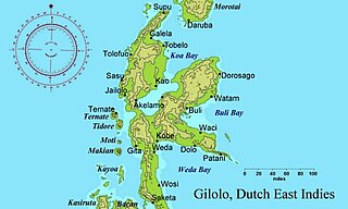
The Sultanate of Jailolo was a premodern state in Maluku, modern Indonesia that emerged with the increasing trade in cloves in the Middle Ages. Also spelt Gilolo, it was one of the four kingdoms of Maluku together with Ternate, Tidore, and Bacan, having its center at a bay on the west side of Halmahera. Jailolo existed as an independent kingdom until 1551 and had separate rulers for periods after that date. A revivalist Raja Jailolo movement made for much social and political unrest in Maluku in the 19th century. In modern times the sultanate has been revived as a symbolic entity.

Fort Kota Janji is a Portuguese fortress located at Jalan Ngade, Laguna Hamlet, Fitu Village, South Ternate District, Ternate, North Maluku Province. It is located on the side of the main road to Ternate City from the south. The fort, which stands firmly at a height of 50 metres (160 ft) above sea level, was originally built during the Portuguese colonial period. Construction was possibly initiated by Governor António de Brito in about 1522. It is locally believed that it was named Fort Kota Janji because it became a silent witness to the peace treaty between Sultan Hairun and the Portuguese Governor. However, the Portuguese broke their vows and took the sultan's life in nearby Fort Kastela in 1570. In 2004, restaurarion work was done at the site of the fort, but only through beautifying the area around the fort by creating a park and build a fence surrounding the site. However, the original shape of the fort is no longer visible.
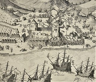
The Portuguese–Ternate wars were a series of conflicts in the Spice Islands in eastern Indonesia between the Portuguese colonizers and their allies on one hand, and the Sultanate of Ternate and its allies, on the other. Hostilities broke out from time to time after the establishment of Portugal in Maluku in 1522, and culminated in an open war from 1570 to 1575, resulting in the expulsion of the Portuguese from Ternate and most of the Spice Islands. The strongly Catholic and Muslim identities of the combatants gave the struggle elements of a war of religion, although this aspect was frequently blurred by cross-faith alliances. It was also an economic war since the Portuguese aim was to control export of the profitable trade in cloves. Portuguese-Ternatan rivalry later merged with attempts of expansion by the Spanish in the Philippines. The Portuguese were eventually defeated in 1605 by an alliance between the Dutch East India Company (VOC) and Ternate, ending their active involvement in Maluku affairs. However, they were soon replaced by the Spanish who maintained an Iberian presence in the region up to 1663.

Fort Victoria is one of former Portuguese forts located in Sirimau District, the center of Ambon City and became the oldest fort in the city. It was built by the Portuguese in 1575, but was later taken over by the Dutch. The fort is one of the tourist attractions on Ambon Island and currently serves as the headquarter of the Pattimura Military Command.

