
Arrifana is a small parish and fishing village in the Faro District's Aljezur Municipality in the Barlavento Algarvio region of Portugal. It is situated near the border between the Aljezur and Alentejo regions on the coast of the Atlantic Ocean and is within the Costa Vicentina park. Arrifana is located about 6 km from Aljezur.
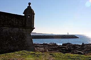
Fort of São Francisco Xavier is a fortification situated along the coast of the civil parish of Nevogilde in the northern Portuguese municipality of Porto.

The Fort of São Sebastião de Caparica also known as the Tower of São Sebastião or Fortress of the Old Tower is a medieval fortification located in Monte da Caparica, civil parish of Caparica, in the municipality of Almada, in the Portuguese central region of Península de Setúbal.

The Fort of São João do Arade, sometimes referred to as the Castle of Arade, is a medieval fortification situated in the civil parish of Ferragudo in the Portuguese Algarve municipality of Lagoa.

The Fort of Santa Catarina is a medieval fort situated in the civil parish of Portimão, in the municipality of Portimão in Portuguese Algarve. The structure was considered one of the last Philippine military projects in the Algarve, erected to defend the peninsula from pirates and privateers, as well as military invasions. Its construction is one of the better examples that work of Alexandre Massai, a military engineer who toured the Algarve to reinforce numerous military fortifications along the coast.

Bordeira is a Portuguese civil parish in the municipality of Aljezur. The population in 2011 was 432, in an area of 79.87 km². It lies within the Southwest Alentejo and Vicentine Coast Natural Park, along the western coast of the Algarve in Faro District. The region, typical of the Algarve coastal areas, is dotted with many beaches, with the most important being the beaches of Praia do Amado and Praia da Bordeira, which attract both local and tourist vacationers. It contains the village of Carrapateira.

The Castle of Alcoutim is a medieval castle in the civil parish of Alcoutim, in the municipality of the same name, in the southeastern Algarve of Portugal. Built in the 13th century, the castle stands in a dominant position on a hill south of the parish seat of Alcoutim on the right bank of the San Marcos River, opposite the territory of Sanlúcar de Guadiana.

The Castle of Aljezur is a medieval castle founded in the parish of Aljezur, in the municipality of the same name overlooking the Aljezur River. Excavations in the castle have discovered that the location was occupied during the Bronze and Iron Ages, while the parade grounds, habitational structures, and two silos date to the 12th and 13th centuries.

Aljezur is a town and municipality of the District of Faro and Algarve region, in Portugal. The population in 2011 was 5,884, in an area of 323.50 km². The municipality comprises 4 parishes.
The Fort of Lagarteira is a medieval fort in the civil parish of Vila Praia de Âncora, municipality of Caminha in the Portuguese Norte, classified as a Property of Public Interest.
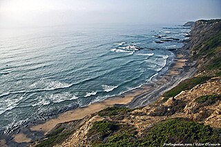
Praia da Carreagem is a beach within the Municipality of Aljezur, in the Algarve, Portugal. The beach is on the western Seaboard in the north west of the Algarve. The beach is 2.6 miles (4.2 km) west of the village of Rogil, and is 71.8 miles (115.6 km) north west, by road, from the regions capital of Faro. The beach is inside the Vicentine Coast Natural Park.

Praia da Amoreira is a beach within the Municipality of Aljezur, in the Algarve, Portugal. The beach is on the western Seaboard in the north west of the Algarve. The beach is 5.4 miles (8.7 km) north west of the village of Aljezur, and is 71.8 miles (115.6 km) north west, by road, from the regions capital of Faro.

Praia do monte Clérigo is a beach within the municipality of Aljezur, in Algarve, Portugal. The beach is on the western Seaboard in the north west of the Algarve. The beach is 5.1 miles (8.2 km) north west of the village of Aljezur, and is 70.0 miles (112.7 km) north west, by road, from the regions capital of Faro. Praia do monte Clérigohas been designated a blue Flag beach (2012).
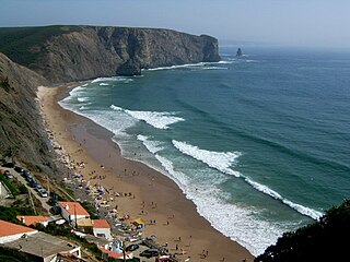
Praia da Arrifana is a beach within the Municipality of Aljezur, in the Algarve, Portugal. The beach is on the western Seaboard in the north west of the Algarve. The beach is 6.0 miles (9.7 km) south south west of the village of Aljezur, and is 71.0 miles (114.3 km) north west, by road, from the regions capital of Faro. The beach of Praia da Arrifana is inside the Vicentine Coast Natural Park, an area of outstanding natural beauty. Praia da Arrifana has been designated a blue Flag beach (2012).
Praia da Pipa is a beach within the Municipality of Aljezur, in the Algarve, Portugal. The beach is on the western Seaboard in the north west of the Algarve. The beach is 6.8 miles (10.9 km) south south west of the village of Aljezur, and is 71.7 miles (115.4 km) north west, by road, from the regions capital of Faro. The beach of Praia da Pipa is inside the Vicentine Coast Natural Park, an area of outstanding natural beauty.

The Fort Nossa Senhora da Luz, also known locally as Castle of Senhora da Luz is a fort in the civil parish of Luz, municipality of Lagos in the Portuguese Algarve, classified as a Property of Public Interest.
The Fort of Santo António de Belixe, which is also referred to as the Fortress of Beliche, is located on Cape St. Vincent in the parish of Sagres, municipality of Vila do Bispo, Faro District, in Portugal. The original date of construction is unknown but the fort was already in existence in the 16th century.

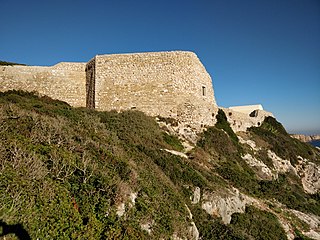
The Ribat of Arrifana is the archeological site of the remains of a Muslim fortification (ribat) situated in Arrifana, Aljezur municipality, in the Faro District of the Algarve region, Portugal. It was a Muslim coastal fortress built around 1130 and is the only such Muslim fortress to have been identified in Portugal, having been excavated by Portuguese archaeologists since 2001.

Fort São Vicente is a military monument in Sagres, in the Algarve region of Portugal. It consists of the remains of a fortification, with a lighthouse inside. It was built in the 16th century to protect a coastal strip and an existing monastery on the site. In 1587 it was destroyed by British privateer Francis Drake, and rebuilt in 1606. In the mid-19th century, a lighthouse was built on the site, which was replaced by a new one in the early 20th century. In the mid-2000s, Cape São Vicente was closed to the public for construction work.

The Fort São João da Barra also known as Fort São João Baptista or Fort Conceição, is located to the east of the town of Cabanas de Tavira, on a small hill below the Ria Formosa in the municipality of Tavira, in Algarve, southern Portugal.


