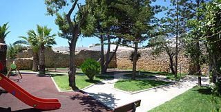
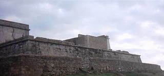
The Fort of Nossa Senhora da Rocha (also known as the Fort of Our Lady of the Rock or Castle of Porches) is a medieval castle situated in the civil parish of Porches, in the municipality of Lagoa in PortugueseAlgarve. Inside the fort is the Chapel of Nossa Senhora da Rocha, of uncertain date.
Doubt continues to exist as to the origin of the Chapel of Nossa Senhora da Rocha, as well as the original fort that existed on this site. The privileged location on a promontory reflects the importance of the site, which was fortified to help secure the coast from Ossonoba (Faro) to Lacobriga (Lagos),[1] as well as protecting the beach and maritime access.[2][3] The 8th century is normally used as a reference, suggesting a construction based on the reuse of existing Roman-era elements.[4] The actual configuration of the temple is difficult to catalog. On one hand, the constructors reused the capitals, presupposing a public construction that occurred in the High Middle Ages.[3] On the other hand, successive remodelling, painting and lack of prior archaeological excavations has made rigorous analysis impossible; this lack of information has contributed to the difficulty in dating and contextualizing the style of architecture.[3] Despite a lack of archaeological research, scholars believe that at the time of the Muslim invasion of the Iberian peninsula, the site was already a military fortification.
In the last few years, different authors have suggested distinct hypothesizes to explain the origin of the temple. Teresa Gamito, on studying the Byzantine presence in the Algarve, saw in the chapel proof of the vitality of Byzantine reconquest of the peninsula.[3][5] To the author, the configuration of the atrium and its similarity with the Chapel of São Pedro de Balsemão, were proofs confirming the Byzantine origins of the temple, whose oriental design was verifiable in the Visigothic epoch.[3] The confusion evident in Gamito's arguments were later reexamined by Manuel Justino Maciel, who systematically deconstructed the indications of its Byzantine-Visigothic construction, while not specifically advancing new data on the building.[3][6]
There are no local records which shed light on the castle or fort, and it is not mentioned in writings until a grant by King Afonso III to his chancellor, D. Estevão (in a document sent to the people of Santa Maria de Faro), dated February 1250. Equally problematic was the proposal of Cláudio Torres, who saw in the chapel a "centre of pilgrimage in the Mozarab epoch".[3][7] The reuse of capitals during the Middle Ages was not only limited to this period, but also again reused during the 9th to 11th century.
The distant Chapel as seen from the promontory, as seen from the east
During the 13th century, King Denis ordered the construction of a fortress to protect the hermitage, whose construction, following the legend of that time, was located on the site of a mysterious Marian apparition.[4]
King John III ordered a reconstruction of the fort around the 16th century, owing to cases of invasions/incursions by Moorish pirates, as well as the defense of the beach for trade.[4]
But dating of the fort is still unclear; there is secure information only after the end of the 16th century, at the time when Tomé Gonçalves was identified as governor.[3][8] But, by 1821, the fort was encountered in an advance state of ruin; there was no indication as to the original perimeter/extent of this fortress.[3][8] It is likely that much of what remains of the fortress was destroyed through successive landslides and destruction caused by ocean swells (to this date, its perimeter continues to be threatened ocean forces).[3]
A final phase of remodelling and reconstruction occurred in the 19th century.[4]
The site was partially restored by the Direcção-Geral dos Edifícios e Monumentos Nacionais (Directorate-General of Buildings and National Monuments), during the 1960s, while proposals to investigate and protect the monument were submitted.[3][4] This included the reconstruction of the walls and repairs to the fort and chapel, demolition of the roof, repairs to the azulejo tile and reconstruction of the pavements (accomplished in 1963); the replacement of the doors and window frames (in 1964); the reconstruction and repair of the pavements and azulejos (in 1965); and the restoration of the walls, repair of the cupola and a clean-up of the landscape within the vicinity of the structures (in 1968).[4] Following an earthquake in 1969, much of the existing fortress was damaged or destroyed.[4]
In 1976, the walls were once again consolidated and new azulejos were added to the chapel. The whitewashing of the structure was completed in 1977.[4]
A new initiative to repair the walls, which also included touches to the chapel and annexes, were completed in 1986.[4]
The site came under the protection of the IPPAR (Instituto Português do Património Arquitectónicoon) on 1 June 1992, under decree law 106F/92, passing under the control of the IGESPAR when this organization took over these responsibilities and jurisdictions.[4]
The chapel is the destination of pilgrimages and annual processions, with the primary festival day associated with the first Sunday of August. During the religious processions the image of the Virgin is taken from the fort, down to the beach.
Architecture
The chapel is composed of two spaces essentially: a large rectangular narthex, open to the exterior through a triple arcade of columns and two Corinthian capitals (dated to the 3rd-4th century); and a rectangular space with cupola, atypical of other regional religious temples.[4] The articulated volumes includes horizontal spaces with tiled roof over the main annex, while the aba extending to the sacristy and pyramidal spire over the main chapel.[4]
The main façade of the chapel (oriented towards the west), includes two spaces that correspond to the galilé and sacristy (which is slightly recessed).[4] The body of the galilé is marked by three arches over two columns of shafts, consisting of a concave base and plinth, with the northern relief consisting of scrolls and palmettes with stylized triangles.[4]
In the interior, the cupola is covered by wood with a modern retable, divided into three section, aligned to the eastern-facing wall. It is marked by a rounded arch, with its nave extending to an altar composed of retable with four ionic columns, presenting an image of the Virgin Mary. The octagonal false cupola is covered in wood framework.[4]
The fort is constituted by a curtain of walls marked by a main gate. The sides of the structures and spire are constructed of reused masonry white-washed and in grey.[4]
Related Research Articles
Vila do Porto is the single municipality, the name of the main town and one of the civil parishes on the island of Santa Maria, in the Portuguese archipelago of Azores. Its nearest neighbor, administratively, is the municipality of Povoação on the southern coast of São Miguel, and it is physically southwest of the islets of the Formigas. The population in 2021 was 5,408, in an area of 96.89 km2 (37.41 sq mi).
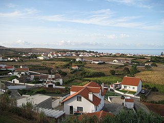
Carvoeiro is a town and a former civil parish in the municipality (concelho) of Lagoa, Algarve, Portugal. In 2013, the parish merged into the new parish Lagoa e Carvoeiro. The population in 2011 was 2,721, in an area of 11.66 km². It is located about 5 kilometres (3.1 mi) south of Lagoa.
Alandroal is a municipality in the Portuguese district of Évora located on the eastern frontier with Spain along the right margin of the Guadiana River in the Central Alentejo region. It is located 341 metres (1,119 ft) above sea level, northeast of Évora and southeast of Estremoz. The population in 2011 was 5,843, in an area of 542.68 km².
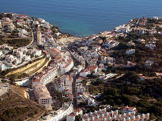
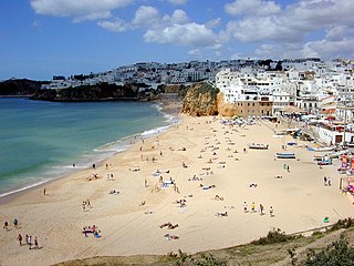
Lagoa is a city and municipality in the district of Faro, in the Portuguese region of Algarve. The population of the municipality in 2011 was 22,975, in an area of 88.25 km². Its urban population, in the city of Lagoa proper, is 6,100 inhabitants. An important travel destination, its coast has won numerous accolades. Marinha Beach was considered by the Michelin Guide as one of the 10 most beautiful beaches in Europe and as one of the 100 most beautiful beaches in the world.
The Church of Nossa Senhora da Conceição is a church in the civil parish of Madalena, in the municipality of Lisbon.
Paderne is a village and civil parish in the municipality (concelho) of Albufeira, in the Portuguese region of Algarve. The population in 2011 was 3,304, in an area of 52.56 km².
The Church of São Lourenço is a Church in the civil parish of Almancil, in the municipality of Loulé in the Portuguese Algarve.
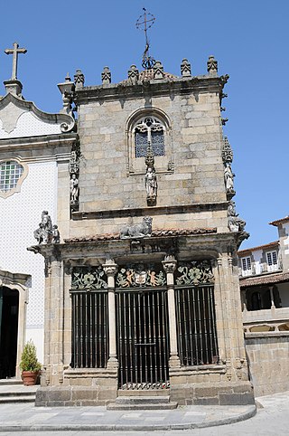
The Chapel of the Coimbras is a Manueline chapel located in the civil parish of São João do Souto, in the municipality of Braga. It has been classified as a National Monument since 1910.
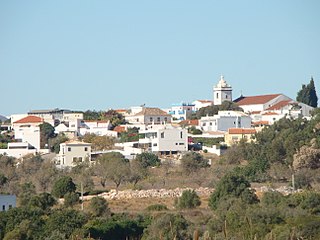
Guia is a town and civil parish in the Portuguese municipality of Albufeira in the Algarve, 5 kilometres (3.1 mi) from the coast. The population in 2011 was 4,376, in an area of 26.80 km².
The Castle of Paderne is an ancient fortification located in the civil parish of Paderne, municipality of Albufeira, in the Portuguese Algarve. It was constructed in the later 12th century by Berbers, in an area around 7.5 kilometres (4.7 mi) inland.
The Fort of Santa Catarina is a medieval fort situated in the civil parish of Portimão, in the municipality of Portimão in Portuguese Algarve. The structure was considered one of the last Philippine military projects in the Algarve, erected to defend the peninsula from pirates and privateers, as well as military invasions. Its construction is one of the better examples that work of Alexandre Massai, a military engineer who toured the Algarve to reinforce numerous military fortifications along the coast.
The Fort of Our Lady of the Incarnation is a small fortification in the civil parish of Carvoeiro, municipality of Lagoa, in Portuguese Algarve.
Mexilhoeira Grande is a civil parish in the municipality (concelho) of Portimão in the southern Portuguese region of the Algarve. The population in 2011 was 4,029, in an area of 91.15 km².
The Castle of Alvor is a medieval castle in the civil parish of Alvor, in the Portuguese district of Faro: considered to be a significant military monument associated with the nearby Castle of Silves.
Albufeira is a city and seat of its own municipality in the district of Faro, in the southernmost Portuguese region of Algarve. The municipality population in 2021 was 44,158, in an area of 140.66 square kilometres. The city proper had a population of 28,645 in 2021. It is 250 kilometres (160 mi) from Lisbon, and is within close proximity of Paderne Castle. Lagoa is located 30 kilometres (19 mi) to the west, and Faro 45 kilometres (28 mi) to the south-east. A tourist destination, Albufeira expands to approximately 300,000 residents during the summer and during the Christmas and New Year celebrations, owing to the number of hotels and lodgings in its municipality, that includes marina facilities, golf courses, restaurants and bars for the annual flood of visitors.
The Hermitage of Nossa Senhora da Conceição is a 16th-century hermitage located in the civil parish of São João Baptista, in the municipality of Tomar, designated as a National Monument in 1910.
Torrão is a civil parish and town, in the municipality of Alcácer do Sal, in the Portuguese district of Setúbal, bordering on the districts of Évora and the Beja. It is crossed by the river Xarrama River. The population in 2011 was 2,295, in an area of 372.39 km2.
The Fort Nossa Senhora da Queimada also knows as Fort of Pessegueiro is a fort situated along the coast of the civil parish of Porto Covo, municipality of Sines, in the southern Alentejo of Portugal, across from the island of the same name.
The Fort Nossa Senhora da Luz, also known locally as Castle of Senhora da Luz is a fort in the civil parish of Luz, municipality of Lagos in the Portuguese Algarve, classified as a Property of Public Interest.
Lopes, João Baptista da Silva (1841), Corografia ou memoria economica, estadistica, e topografica do reino do Algarve (in Portuguese), Lisbon, Portugal
Oliveira, Francisco Ataíde (1912), Monografia de Porches (in Portuguese), Porto, Portugal: Concelho de Lagoa
Lopes, João Baptista da Silva (1841), Corografia ou memoria economica, estadistica, e topografica do reino do Algarve (in Portuguese), Lisbon, Portugal
Gamito, Teresa Júdice (1997), "Ipses (Vila Velha)", in Faria, António Marques de; Barata, Maria Filomena (eds.), Noventa séculos entre a Serra e o Mar, Lisbon, Portugal: Instituto Português do Património Arquitectónico, pp.257–263
Coutinho, Valdemar (1997), Castelos, fortalezas e torres da região do Algarve (in Portuguese), Faro, Portugal
Maciel, Manuel Justino Pinheiro (2003), "O território de Balsa na Antiguidade Tardia", Tavira. Território e Poder, catálogo de exposição (in Portuguese), Lisbon, Portugal, pp.105–126
Macias, Santiago; Torres, Claudio; Gomez, Susana (1999), Terras da Moura encantada (in Portuguese), Lisbon, Portugal, p.161
Name of the fort inserted in its district or autonomous region.
This page is based on this Wikipedia article Text is available under the CC BY-SA 4.0 license; additional terms may apply. Images, videos and audio are available under their respective licenses.