Fulton, Indiana

Last updated

Town of Fulton, Indiana
Main Street 20-10-22 066.jpg
Fulton, Indiana.
Fulton County Indiana Incorporated and Unincorporated areas Fulton Highlighted 1826152.svg
Location of Fulton in Fulton County, Indiana.
Coordinates: 40°56′47″N86°15′51″W / 40.94639°N 86.26417°W / 40.94639; -86.26417
Country United States
State Indiana
County Fulton
Township Liberty
Area
[1]
  Total0.19 sq mi (0.48 km2)
  Land0.19 sq mi (0.48 km2)
  Water0.00 sq mi (0.00 km2)
Elevation
[2]
784 ft (239 m)
Population
 (2020)
  Total303
  Density1,629.03/sq mi (627.49/km2)
Time zone UTC-5 (EST)
  Summer (DST) UTC-5 (EST)
ZIP code
46931
Area code 574
FIPS code 18-26152 [3]
GNIS feature ID2396953 [2]

Fulton is a town in Liberty Township, Fulton County, Indiana, United States. The population was 333 at the 2010 census.

Contents

History

Fulton took its name from Fulton County. [4] The Fulton post office was established in 1843. [5] In 1850 the first log cabin was erected in Fulton. Robert Aitken and family were the first occupants of the cabin and occupied a saw mill in the town. The village roads and markers were laid out in 1851 by Judge Wright of Logansport. The first schoolhouse was erected in 1845. In 1909 the first brick school was built. In 1852 the first church was erected by the Methodists. In late 1853 the Baptists also organized a church. Robert Aitken, the first settler, was appointed by the government as first postmaster in 1851. A tannery was established in 1851, and then a second tannery in 1853. Other additional businesses included a blacksmith shop, a grist mill, a carpet weaver, and an inn, erected in 1852 and eventually became a hotel. There was also a wood shop and other small businesses. The town's first doctor, Franklin C. Dielman, came to town after his graduation from medical school. The first child delivered by Dr. Dielman was Hiram Ford, the first baby girl was Kathleen Rannels Carrithers. Fulton's first bank was opened in 1907. The first newspaper, “The Fulton Leader” was established in 1901. A library was organized in 1920 and became a part of the Fulton County Library system in 1921. The Knights of Pythias was organized in 1905; The Masonic Lodge in 1906, followed by the Eastern Star in 1912. Fulton's first street lights were installed in the summer of 1916. [6]

Geography

According to the 2010 census, Fulton has a total area of 0.18 square miles (0.47 km2), all land. [7]

Demographics

Historical population
CensusPop.Note
1910 296
1920 36122.0%
1930 39710.0%
1940 373−6.0%
1950 366−1.9%
1960 41012.0%
1970 372−9.3%
1980 3935.6%
1990 371−5.6%
2000 326−12.1%
2010 3332.1%
2020 303−9.0%
U.S. Decennial Census [8]

2010 census

As of the census [9] of 2010, there were 333 people, 128 households, and 89 families residing in the town. The population density was 1,850.0 inhabitants per square mile (714.3/km2). There were 145 housing units at an average density of 805.6 per square mile (311.0/km2). The racial makeup of the town was 98.2% White and 1.8% from other races. Hispanic or Latino of any race were 2.1% of the population.

There were 128 households, of which 39.1% had children under the age of 18 living with them, 48.4% were married couples living together, 9.4% had a female householder with no husband present, 11.7% had a male householder with no wife present, and 30.5% were non-families. 25.8% of all households were made up of individuals, and 10.1% had someone living alone who was 65 years of age or older. The average household size was 2.60 and the average family size was 3.07.

The median age in the town was 36.9 years. 30.3% of residents were under the age of 18; 7.5% were between the ages of 18 and 24; 22.8% were from 25 to 44; 23.7% were from 45 to 64; and 15.6% were 65 years of age or older. The gender makeup of the town was 50.8% male and 49.2% female.

2000 census

As of the census [3] of 2000, there were 326 people, 127 households, and 93 families residing in the town. The population density was 1,797.9 inhabitants per square mile (694.2/km2). There were 142 housing units at an average density of 783.1 per square mile (302.4/km2). The racial makeup of the town was 99.69% White, 0.31% from other races.

There were 127 households, out of which 37.0% had children under the age of 18 living with them, 63.8% were married couples living together, 7.1% had a female householder with no husband present, and 26.0% were non-families. 24.4% of all households were made up of individuals, and 11.8% had someone living alone who was 65 years of age or older. The average household size was 2.57 and the average family size was 3.04.

In the town, the population was spread out, with 26.7% under the age of 18, 7.7% from 18 to 24, 32.5% from 25 to 44, 17.8% from 45 to 64, and 15.3% who were 65 years of age or older. The median age was 34 years. For every 100 females, there were 97.6 males. For every 100 females age 18 and over, there were 89.7 males.

The median income for a household in the town was $44,375, and the median income for a family was $47,500. Males had a median income of $32,045 versus $25,547 for females. The per capita income for the town was $16,732. About 3.3% of families and 2.4% of the population were below the poverty line, including 2.5% of those under age 18 and none of those age 65 or over.

Education

Fulton has a public library, a branch of the Fulton County Public Library. [10]

Related Research Articles

<span class="mw-page-title-main">Ambia, Indiana</span> Town in Indiana, United States

Ambia is a town in Hickory Grove Township, Benton County, Indiana, United States. The population was 239 at the 2010 census. It is part of the Lafayette, Indiana Metropolitan Statistical Area.

<span class="mw-page-title-main">Earl Park, Indiana</span> Town in Indiana, United States

Earl Park is a town in Richland Township, Benton County, Indiana, United States. The population was 348 at the 2010 census. It is part of the Lafayette, Indiana Metropolitan Statistical Area.

<span class="mw-page-title-main">Fowler, Indiana</span> Town in Indiana, United States

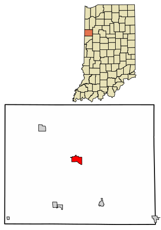
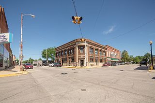
Fowler is a town in, and county seat of Center Township, Benton County, Indiana, United States. The population was 2,337 at the 2020 census. It is part of the Lafayette, Indiana Metropolitan Statistical Area.

<span class="mw-page-title-main">Ashley, Indiana</span> Town in Indiana, United States

Ashley is a town in Indiana located on the border of Smithfield Township, DeKalb County and Steuben Township, Steuben County. The population was 983 at the 2010 census.

<span class="mw-page-title-main">Akron, Indiana</span> Town in Indiana, United States

Akron is a town in Henry Township, Fulton County, Indiana, United States. The population was 1,167 at the 2010 census.

<span class="mw-page-title-main">Kewanna, Indiana</span> Town in Indiana, United States

Kewanna is a town in Union Township, Fulton County, Indiana, United States. The population was 613 at the 2010 census.

<span class="mw-page-title-main">Rochester, Indiana</span> City in Indiana

Rochester is a city in, and the county seat of, Fulton County, Indiana, United States. The population was 6,270 at the 2020 census.

<span class="mw-page-title-main">Hazleton, Indiana</span> Town in Indiana, United States

Hazleton is a town in White River Township, Gibson County, Indiana, United States. The population was 263 at the 2010 census making it the second smallest community in the county. While having almost no connection to it, it is part of the Evansville, Indiana, Metropolitan Area.

<span class="mw-page-title-main">Wilkinson, Indiana</span> Town in Indiana, United States

Wilkinson is a town in Brown Township, Hancock County, Indiana, United States. The population was 449 at the 2010 census.

<span class="mw-page-title-main">Andrews, Indiana</span> Town in Indiana, United States

Andrews is a town in Dallas Township, Huntington County, Indiana, United States. The population was 1,048 at the 2020 census.

<span class="mw-page-title-main">Kingsbury, Indiana</span> Town in Indiana, United States

Kingsbury is a town in Washington Township, LaPorte County, Indiana, just northwest of the intersection of U.S. Route 35 and U.S. Route 6. The town was founded in 1835 and incorporated on March 3, 1941. During 1940 - 1941, the Kingsbury Ordnance Plant (KOP) was built for use during World War II. The plant closed after the war but reopened during the Korean War, closing permanently in 1959. The population was 242 at the 2010 census. It is included in the Michigan City, Indiana-La Porte, Indiana Metropolitan Statistical Area. The town has its own fire department, KVFD, and a Greek revival style First Baptist church built in 1851 with its own graveyard and Winchell Cemetery.

<span class="mw-page-title-main">Bethany, Indiana</span> Town in Indiana, United States

Bethany is a town in Clay Township, Morgan County, in the U.S. state of Indiana. The population was 95 at the 2020 census.

<span class="mw-page-title-main">Paragon, Indiana</span> Town in Indiana, United States

Paragon is a town in Ray Township, Morgan County, in the U.S. state of Indiana. The population was 556 at the 2020 census, down from 659 in 2010.

<span class="mw-page-title-main">Hardinsburg, Indiana</span> Census-designated place in Indiana, United States

Hardinsburg is a census-designated place in Posey Township, Washington County, in the U.S. state of Indiana. The population was 222 at the 2020 census.

<span class="mw-page-title-main">Boston, Indiana</span> Town in Indiana, United States

Boston is a town in Boston Township, Wayne County, Indiana, United States. The population was 138 at the 2010 census.

<span class="mw-page-title-main">East Germantown, Indiana</span> Town in Indiana, United States

East Germantown is a town in Jackson Township, Wayne County, in the U.S. state of Indiana. The population was 410 at the 2010 census.

<span class="mw-page-title-main">Metamora, Ohio</span> Village in Ohio, United States

Metamora is a village in Fulton County, Ohio, United States. The population was 566 at the 2020 census.

<span class="mw-page-title-main">Fulton, Ohio</span> Village in Ohio, United States

Fulton is a village in Morrow County, Ohio, United States. The population was 250 at the 2020 census. Fulton is south of Mount Gilead, the county seat.

<span class="mw-page-title-main">White Township, Indiana County, Pennsylvania</span> Township in Pennsylvania, United States

White Township is a township in Indiana County, Pennsylvania, United States. The population was 15,242 at the 2020 census.

<span class="mw-page-title-main">Fulton, South Dakota</span> Town in South Dakota, United States

Fulton is a town in Hanson County, South Dakota, United States. It is part of the Mitchell, South Dakota Micropolitan Statistical Area. The population was 87 at the 2020 census.

References

  1. "2020 U.S. Gazetteer Files". United States Census Bureau. Retrieved March 16, 2022.
  2. 1 2 U.S. Geological Survey Geographic Names Information System: Fulton, Indiana
  3. 1 2 "U.S. Census website". United States Census Bureau . Retrieved January 31, 2008.
  4. Baker, Ronald L. (October 1995). From Needmore to Prosperity: Hoosier Place Names in Folklore and History . Indiana University Press. p.  140. ISBN   978-0-253-32866-3. This town was named for Fulton County...
  5. "Fulton County". Jim Forte Postal History. Archived from the original on September 10, 2014. Retrieved September 10, 2014.
  6. Fulton County Historical Society Quarterly, February 1972, Volume 8, #1, Mrs. Kline (Leatha) D. Reed
  7. "G001 - Geographic Identifiers - 2010 Census Summary File 1". United States Census Bureau. Archived from the original on February 13, 2020. Retrieved July 16, 2015.
  8. "Census of Population and Housing". Census.gov. Retrieved June 4, 2015.
  9. "U.S. Census website". United States Census Bureau . Retrieved December 11, 2012.
  10. "Branches". Fulton County Public Library. Retrieved March 7, 2018.