A GIS file format is a standard of encoding geographical information into a computer file. They are created mainly by government mapping agencies or by GIS software developers.
GeoTIFF is a public domain metadata standard which allows georeferencing information to be embedded within a TIFF file. The potential additional information includes map projection, coordinate systems, ellipsoids, datums, and everything else necessary to establish the exact spatial reference for the file. The GeoTIFF format is fully compliant with TIFF 6.0, so software incapable of reading and interpreting the specialized metadata will still be able to open a GeoTIFF format file.
A GIS software program is a computer program to support the use of a geographic information system, providing the ability to create, store, manage, query, analyze, and visualize geographic data, that is, data representing phenomena for which location is important. The GIS software industry encompasses a broad range of commercial and open-source products that provide some or all of these capabilities within various information technology architectures.

Sol Katz was an American software developer who pioneered geospatial computer software and left behind a large body of work in the form of computer applications and format specifications while at the U.S. Bureau of Land Management. This early archive provided both source code and applications freely available to the community, including the Windows application PC-MOSS, where MOSS is the earliest known Open Source Geographic Information System. Katz was also a frequent contributor to many geospatial list servers.

Manifold System is a geographic information system (GIS) software package developed by Manifold Software Limited that runs on Microsoft Windows. Manifold System handles both vector and raster data, includes spatial SQL, a built-in Internet Map Server (IMS), and other general GIS features.
A Web Map Service (WMS) is a standard protocol developed by the Open Geospatial Consortium in 1999 for serving georeferenced map images over the Internet. These images are typically produced by a map server from data provided by a GIS database.

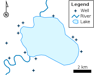
The shapefile format is a geospatial vector data format for geographic information system (GIS) software. It is developed and regulated by Esri as a mostly open specification for data interoperability among Esri and other GIS software products. The shapefile format can spatially describe vector features: points, lines, and polygons, representing, for example, water wells, rivers, and lakes. Each item usually has attributes that describe it, such as name or temperature.
MrSID is an acronym that stands for multiresolution seamless image database. It is a file format developed and patented by LizardTech for encoding of georeferenced raster graphics, such as orthophotos.

Java Unified Mapping Program (JUMP) is a Java based vector and raster GIS and programming framework. Current development continues under the OpenJUMP name.

QGIS is a free and open-source cross-platform desktop geographic information system (GIS) application that supports viewing, editing, printing, and analysis of geospatial data.
The Open Source Geospatial Foundation (OSGeo), is a non-profit non-governmental organization whose mission is to support and promote the collaborative development of open geospatial technologies and data. The foundation was formed in February 2006 to provide financial, organizational and legal support to the broader Free and open-source geospatial community. It also serves as an independent legal entity to which community members can contribute code, funding and other resources.
JTS Topology Suite is an open-source Java software library that provides an object model for Euclidean planar linear geometry together with a set of fundamental geometric functions. JTS is primarily intended to be used as a core component of vector-based geomatics software such as geographical information systems. It can also be used as a general-purpose library providing algorithms in computational geometry.

OpenEV is an open-source geospatial toolkit and a frontend to that toolkit. OpenEV was developed using Python and uses the GDAL library to display georeferenced images and elevation data. The application also has image editing capabilities and uses OpenGL to display elevation data in three-dimensions.
Integrated Land and Water Information System (ILWIS) is a geographic information system (GIS) and remote sensing software for both vector and raster processing. Its features include digitizing, editing, analysis and display of data, and production of quality maps. ILWIS was initially developed and distributed by ITC Enschede in the Netherlands for use by its researchers and students. Since 1 July 2007, it has been released as free software under the terms of the GPL-2.0-only license. Having been used by many students, teachers and researchers for more than two decades, ILWIS is one of the most user-friendly integrated vector and raster software programmes currently available. ILWIS has some very powerful raster analysis modules, a high-precision and flexible vector and point digitizing module, a variety of very practical tools, as well as a great variety of user guides and training modules all available for downloading. The current version is ILWIS 3.8.6. Similar to the GRASS GIS in many respects, ILWIS is currently available natively only on Microsoft Windows. However, a Linux Wine manual has been released.
The Open Geospatial Consortium Web Coverage Service Interface Standard (WCS) defines Web-based retrieval of coverages – that is, digital geospatial information representing space/time-varying phenomena.

In computer science, Orfeo Toolbox (OTB) is a software library for processing images from Earth observation satellites.
Mapnik is an open-source mapping toolkit for desktop and server based map rendering, written in C++. Artem Pavlenko, the original developer of Mapnik, set out with the explicit goal of creating beautiful maps by employing the sub-pixel anti-aliasing of the Anti-Grain Geometry (AGG) library. Mapnik now also has a Cairo rendering backend. For handling common software tasks such as memory management, file system access, regular expressions, and XML parsing, Mapnik utilizes the Boost C++ libraries. An XML file can be used to define a collection of mapping objects that determine the appearance of a map, or objects can be constructed programmatically in C++, Python, and Node.js.

SpatiaLite is a spatial extension to SQLite, providing vector geodatabase functionality. It is similar to PostGIS, Oracle Spatial, and SQL Server with spatial extensions, although SQLite/SpatiaLite aren't based on client-server architecture: they adopt a simpler personal architecture. i.e. the whole SQL engine is directly embedded within the application itself: a complete database simply is an ordinary file which can be freely copied and transferred from one computer/OS to a different one without any special precaution.
Vector tiles, tiled vectors or vectiles are packets of geographic data, packaged into pre-defined roughly-square shaped "tiles" for transfer over the web. This is an emerging method for delivering styled web maps, combining certain benefits of pre-rendered raster map tiles with vector map data. As with the widely used raster tiled web maps, map data is requested by a client as a set of "tiles" corresponding to square areas of land of a pre-defined size and location. Unlike raster tiled web maps, however, the server returns vector map data, which has been clipped to the boundaries of each tile, instead of a pre-rendered map image.
A GeoPackage (GPKG) is an open, non-proprietary, platform-independent and standards-based data format for geographic information system implemented as a SQLite database container. Defined by the Open Geospatial Consortium (OGC) with the backing of the US military and published in 2014, GeoPackage has seen widespread support from various government, commercial, and open source organizations.


