
Geographic Resources Analysis Support System is a geographic information system (GIS) software suite used for geospatial data management and analysis, image processing, producing graphics and maps, spatial and temporal modeling, and visualizing. It can handle raster, topological vector, image processing, and graphic data.
GeoTIFF is a public domain metadata standard which allows georeferencing information to be embedded within a TIFF file. The potential additional information includes map projection, coordinate systems, ellipsoids, datums, and everything else necessary to establish the exact spatial reference for the file. The GeoTIFF format is fully compliant with TIFF 6.0, so software incapable of reading and interpreting the specialized metadata will still be able to open a GeoTIFF format file.

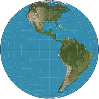
The equirectangular projection (also called the equidistant cylindrical projection or la carte parallélogrammatique projection, and which includes the special case of the plate carrée projection, is a simple map projection attributed to Marinus of Tyre, who Ptolemy claims invented the projection about AD 100. The projection maps meridians to vertical straight lines of constant spacing, and circles of latitude to horizontal straight lines of constant spacing. The projection is neither equal area nor conformal. Because of the distortions introduced by this projection, it has little use in navigation or cadastral mapping and finds its main use in thematic mapping. In particular, the plate carrée has become a standard for global raster datasets, such as Celestia, NASA World Wind, and Natural Earth, because of the particularly simple relationship between the position of an image pixel on the map and its corresponding geographic location on Earth. In addition it is frequently used in panoramic photography to represent a spherical panoramic image.
Sol Katz was an American software developer who pioneered geospatial computer software and left behind a large body of work in the form of computer applications and format specifications while at the U.S. Bureau of Land Management. This early archive provided both source code and applications freely available to the community. Katz was also a frequent contributor to many geospatial list servers.
A Web Map Service (WMS) is a standard protocol developed by the Open Geospatial Consortium in 1999 for serving georeferenced map images over the Internet. These images are typically produced by a map server from data provided by a GIS database.

A spatial reference system (SRS) or coordinate reference system (CRS) is a coordinate-based local, regional or global system used to locate geographical entities. A SRS commonly defines a specific map projection, as well as transformations between different SRS.

QGIS is a free and open-source cross-platform desktop geographic information system (GIS) application that supports viewing, editing, and analysis of geospatial data.
The Open Source Geospatial Foundation (OSGeo), is a non-profit non-governmental organization whose mission is to support and promote the collaborative development of open geospatial technologies and data. The foundation was formed in February 2006 to provide financial, organizational and legal support to the broader Free and open-source geospatial community. It also serves as an independent legal entity to which community members can contribute code, funding and other resources.

The Geospatial Data Abstraction Library (GDAL) is a computer software library for reading and writing raster and vector geospatial data formats, and is released under the permissive X/MIT style free software license by the Open Source Geospatial Foundation. As a library, it presents a single abstract data model to the calling application for all supported formats. It may also be built with a variety of useful command line interface utilities for data translation and processing. Projections and transformations are supported by the PROJ library.
MapServer is an open-source development environment for building spatially enabled internet applications, built in the C language, and is widely known as one of the fastest Web mapping engines available. It can run as a CGI program or via MapScript which supports several programming languages. MapServer can access hundreds of data formats, any raster or vector format supported by GDAL, and reprojections on-the-fly are handled by PROJ. MapServer was originally developed by Steve Lime, then working at the University of Minnesota — so, it was previously referred to as "UMN MapServer", to distinguish it from commercial "map servers"; today it is commonly referred to as just "MapServer", and is maintained by the MapServer Project Steering Committee (PSC). MapServer was originally developed with support from NASA, which needed a way to make its satellite imagery available to the public.
OpenLayers is an open-source JavaScript library for displaying map data in web browsers as slippy maps. It provides an API for building rich web-based geographic applications similar to Google Maps and Bing Maps.
The General Perspective projection is a map projection. When the Earth is photographed from space, the camera records the view as a perspective projection. When the camera is aimed toward the center of the Earth, the resulting projection is called Vertical Perspective. When aimed in other directions, the resulting projection is called a Tilted Perspective.

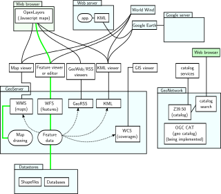
A Web mapping or an online mapping is the process of using the maps delivered by geographic information systems (GIS) on the Internet, more specifically in the World Wide Web (WWW). A web map or an online map is both served and consumed, thus web mapping is more than just web cartography, it is a service by which consumers may choose what the map will show. Web GIS emphasizes geodata processing aspects more involved with design aspects such as data acquisition and server software architecture such as data storage and algorithms, than it does the end-user reports themselves.
NetCDF is a set of software libraries and self-describing, machine-independent data formats that support the creation, access, and sharing of array-oriented scientific data. The project homepage is hosted by the Unidata program at the University Corporation for Atmospheric Research (UCAR). They are also the chief source of netCDF software, standards development, updates, etc. The format is an open standard. NetCDF Classic and 64-bit Offset Format are an international standard of the Open Geospatial Consortium.
The Hellenic Geodetic Reference System 1987 or HGRS87 is a geodetic system commonly used in Greece (SRID=2100). The system specifies a local geodetic datum and a projection system. In some documents it is called Greek Geodetic Reference System 1987 or GGRS87.
GIS Live DVD is a type of the thematic Live CD containing GIS/RS applications and related tutorials, and sample data sets. The general sense of a GIS Live DVD is to demonstrate the power of FLOSS GIS and encourage users to start on FLOSS GIS. However, a disc can be used for GIS data processing and training, too. A disc usually includes some selected Linux-based or Wine (software)-enabled Windows applications for GIS and Remote Sensing use. Using this disc the end users can execute GIS functions to get experience in free and open source software solutions or solve some simple business operations. The set-up and the operating behaviour of the applications can also be studied prior to building real FLOSS GIS-based systems. Recently a LiveDVD image is stored and booted from USB.
Absoft Fortran Compilers are set of Fortran compilers for Microsoft Windows, Apple Macintosh, and Linux produced by Absoft Corporation. The compilers are source code compatible across platforms.

Web Mercator, Google Web Mercator, Spherical Mercator, WGS 84 Web Mercator or WGS 84/Pseudo-Mercator is a variant of the Mercator projection and is the de facto standard for Web mapping applications. It rose to prominence when Google Maps adopted it in 2005. It is used by virtually all major online map providers, including Google Maps, Mapbox, Bing Maps, OpenStreetMap, Mapquest, Esri, and many others. Its official EPSG identifier is EPSG:3857, although others have been used historically.
Well-known text representation of coordinate reference systems is a text markup language for representing spatial reference systems and transformations between spatial reference systems. The formats were originally defined by the Open Geospatial Consortium (OGC) and described in their Simple Feature Access and Well-known text representation of coordinate reference systems specifications. The current standard definition is ISO 19162:2019. This supersedes ISO 19162:2015.