GOES-11, known as GOES-L before becoming operational, is an American weather satellite, which is part of the US National Oceanic and Atmospheric Administration's Geostationary Operational Environmental Satellite system. It was launched in 2000, and operated at the GOES-WEST position, providing coverage of the west coast of the United States, until December 6, 2011.

GOES-10, known as GOES-K before becoming operational, was an American weather satellite, which formed part of the US National Oceanic and Atmospheric Administration's Geostationary Operational Environmental Satellite system. It was launched in 1997, and after completing operations as part of the main GOES system, it was kept online as a backup spacecraft until December 2009, providing coverage of South America as GOES-SOUTH, and being used to assist with hurricane predictions for North America. It was retired and maneuvered to a graveyard orbit on 1 December 2009.

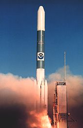
GOES-9, known as GOES-J before becoming operational, was an American weather satellite, which formed part of the U.S. National Oceanic and Atmospheric Administration's Geostationary Operational Environmental Satellite system. It was launched in 1995, and operated until 2007 when it was retired and boosted to a graveyard orbit. At launch, the satellite had a mass of 2,105 kilograms (4,641 lb), and an expected operational lifespan of three years. It was built by Space Systems/Loral, based on the LS-1300 satellite bus, and was the second of five GOES-I series satellites to be launched.
GOES-8, known as GOES-I before becoming operational, was an American weather satellite, which formed part of the US National Oceanic and Atmospheric Administration's Geostationary Operational Environmental Satellite system. It was launched in 1994, and operated until 2004 when it was retired and boosted to a graveyard orbit. At launch, the satellite had a mass of 2,105 kilograms (4,641 lb), and an expected operational lifespan of three or five years. It was built by Space Systems/Loral, based on the LS-1300 satellite bus, and was the first of five GOES-I series satellites to be launched.

GOES-7, known as GOES-H before becoming operational, is an American satellite. It was originally built as a weather satellite, and formed part of the US National Oceanic and Atmospheric Administration's Geostationary Operational Environmental Satellite system. Originally built as a ground spare, GOES-H was launched in 1987 due to delays with the next series of satellites. It was operated by NOAA until 1999, before being leased to Peacesat, who use it as a communications satellite. As of 2009, it was operational over the Pacific Ocean, providing communications for the Pacific Islands. On April 12, 2012, the spacecraft was finally decommissioned and moved to a graveyard orbit.
Eutelsat 113 West A, formerly Satmex-6, is a geostationary communications satellite which is operated by Eutelsat. Originally built for Mexico's Satmex, it was launched in 2006. The satellite was acquired by Eutelsat in its 2014 merger with Satmex, and renamed Eutelsat 113 West A in May. It is used to provide communications services to the Americas, Hawaii and the Caribbean.
EchoStar X, also known as EchoStar 10, is an American geostationary communications satellite which is operated by EchoStar on behalf of Dish Network. It is positioned in Geostationary orbit at a longitude of 110° West, from where it is used to provide direct broadcasting services to the United States.
INSAT-2E is an Indian geostationary communications and weather satellite which is operated by the Indian National Satellite System. It is positioned in geostationary orbit at a longitude of 83° East, from where it is used to provide communications services to Asia and Australia. It also carries two meteorological instruments; the Very High Resolution Radiometer, and a CCD camera capable of returning images with a resolution of one kilometre.
JCSAT-4A, designated JCSAT-6 before launch, is a Japanese geostationary communications satellite which is operated by JSAT Corporation. It is positioned in geostationary orbit at a longitude of 124° East, from where it is used to provide broadcasting and corporate network communications to Japan.

TDRS-4, known before launch as TDRS-D, is an American communications satellite, of first generation, which was operated by NASA as part of the Tracking and Data Relay Satellite System from 1989 until 2011. It was constructed by TRW, based on a custom satellite bus which was used for all seven of the first generation TDRS satellites.

TDRS-7, known before launch as TDRS-G, is an American communications satellite, of first generation, which is operated by NASA as part of the Tracking and Data Relay Satellite System. It was constructed by TRW as a replacement for TDRS-B, which had been lost in the Challenger accident, and was the last first generation TDRS satellite to be launched.

TDRS-9, known before launch as TDRS-I, was an American communications satellite which was operated by NASA as part of the Tracking and Data Relay Satellite System. It was constructed by the Boeing Satellite Development Center, formerly Hughes Space and Communications, and was based on the BSS-601 satellite bus. It was the second Advanced TDRS, or second-generation Tracking and Data Relay Satellite, to be launched.

TDRS-10, known before launch as TDRS-J, is an American communications satellite which is operated by NASA as part of the Tracking and Data Relay Satellite System. It was constructed by the Boeing Satellite Development Center, formerly Hughes Space and Communications, and is based on the BSS-601 satellite bus. It was the third and final Advanced TDRS, or second-generation Tracking and Data Relay Satellite, to be launched.
Galaxy 11 is an American geostationary communications satellite which is operated by Intelsat. It is located in geostationary orbit at a longitude of 32.8 degrees east, where it serves as a backup to the Intelsat 802 spacecraft. It was originally operated at 99° West and later spent most of its operational life at 91° West, from where it was used to provide communications services to Brazil and North America.

GOES-2, known as GOES-B before becoming operational, was a geostationary weather satellite which was operated by the United States National Oceanic and Atmospheric Administration as part of the Geostationary Operational Environmental Satellite system. GOES-2 was built by Ford Aerospace, and was based on the satellite bus developed for the Synchronous Meteorological Satellite programme. At launch it had a mass of 295 kilograms (650 lb). It was positioned in geostationary orbit, from where it was used for weather forecasting in the United States. Following its retirement as a weather satellite, it was used as a communications satellite until its final decommissioning in 2001.

GOES-3, known as GOES-C before becoming operational, was an American geostationary weather and communications satellite. It was originally built for the National Oceanic and Atmospheric Administration as part of the Geostationary Operational Environmental Satellite system, and was launched in June 1978. It was positioned in geostationary orbit, from where it was initially used for weather forecasting in the United States. Since ceasing to function as a weather satellite in 1989, it was used as a communications satellite, and spent over thirty-eight years in operation. GOES-3 was decommissioned 29 June 2016 at the Center for Southeastern Tropical Advanced Remote Sensing facility in Miami, Florida.

GOES-4, known as GOES-D before becoming operational, was a geostationary weather satellite which was operated by the United States National Oceanic and Atmospheric Administration as part of the Geostationary Operational Environmental Satellite system. Launched in 1980, it was used for weather forecasting in the United States, and later in Europe. Following its retirement it became the first satellite to be sent into a graveyard orbit.
GOES-6, known as GOES-F before becoming operational, was a geostationary weather satellite which was operated by the United States National Oceanic and Atmospheric Administration as part of the Geostationary Operational Environmental Satellite system. Launched in 1983, it was used for weather forecasting in the United States.
Intelsat 605, previously named Intelsat VI F-5, was a communications satellite operated by Intelsat. Launched in 1991, it was the fourth of five Intelsat VI satellites to be launched. The Intelsat VI series was constructed by Hughes Aircraft, based on the HS-389 satellite bus.