
A geographic information system (GIS) consists of integrated computer hardware and software that store, manage, analyze, edit, output, and visualize geographic data. Much of this often happens within a spatial database, however, this is not essential to meet the definition of a GIS. In a broader sense, one may consider such a system also to include human users and support staff, procedures and workflows, the body of knowledge of relevant concepts and methods, and institutional organizations.

The Geography Markup Language (GML) is the XML grammar defined by the Open Geospatial Consortium (OGC) to express geographical features. GML serves as a modeling language for geographic systems as well as an open interchange format for geographic transactions on the Internet. Key to GML's utility is its ability to integrate all forms of geographic information, including not only conventional "vector" or discrete objects, but coverages and sensor data.
A GIS file format is a standard for encoding geographical information into a computer file, as a specialized type of file format for use in geographic information systems (GIS) and other geospatial applications. Since the 1970s, dozens of formats have been created based on various data models for various purposes. They have been created by government mapping agencies, GIS software vendors, standards bodies such as the Open Geospatial Consortium, informal user communities, and even individual developers.

Geomatics is defined in the ISO/TC 211 series of standards as the "discipline concerned with the collection, distribution, storage, analysis, processing, presentation of geographic data or geographic information". Under another definition, it consists of products, services and tools involved in the collection, integration and management of geographic (geospatial) data. It is also known as geomatic(s) engineering. Surveying engineering was the widely used name for geomatic(s) engineering in the past.

Geomatics engineering is a rapidly developing engineering discipline which focuses on spatial information. The location is the primary factor used to integrate a very wide range of data for spatial analysis and visualization. Geomatics engineers design, develop, and operate systems for collecting and analyzing spatial information about the land, the oceans, natural resources, and manmade features.

Geoinformatics is a technical science primarily within the domain of Computer Science. It focuses on the programming of applications, spatial data structures, and the analysis of objects and space-time phenomena related to the surface and underneath of Earth and other celestial bodies. The field develops software and web services to model and analyse spatial data, serving the needs of geosciences and related scientific and engineering disciplines. The term is often used interchangeably with Geomatics, although the two have distinct focuses; Geomatics emphasizes acquiring spatial knowledge and leveraging information systems, not their development.
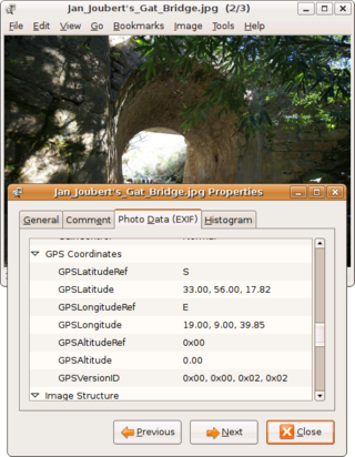
Geotagging, or GeoTagging, is the process of adding geographical identification metadata to various media such as a geotagged photograph or video, websites, SMS messages, QR Codes or RSS feeds and is a form of geospatial metadata. This data usually consists of latitude and longitude coordinates, though they can also include altitude, bearing, distance, accuracy data, and place names, and perhaps a time stamp.
Geographic information science or geoinformation science is a scientific discipline at the crossroads of computational science, social science, and natural science that studies geographic information, including how it represents phenomena in the real world, how it represents the way humans understand the world, and how it can be captured, organized, and analyzed. It is a sub-field of geography, specifically part of technical geography. It has applications to both physical geography and human geography, although its techniques can be applied to many other fields of study as well as many different industries.
ISO/TC 211 is a standard technical committee formed within ISO, tasked with covering the areas of digital geographic information and geomatics. It is responsible for preparation of a series of International Standards and Technical Specifications numbered in the number range starting at ISO-19101. The Chair of the committee was 1994-2016: Olaf Østensen; during 2017-2018: Christina Wasström; and from 2019 Agneta Gren Engberg.
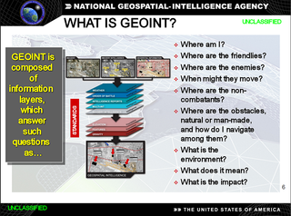
In the United States, geospatial intelligence (GEOINT) is intelligence about the human activity on earth derived from the exploitation and analysis of imagery, signals, or signatures with geospatial information. GEOINT describes, assesses, and visually depicts physical features and geographically referenced activities on the Earth. GEOINT, as defined in US Code, consists of imagery, imagery intelligence (IMINT) and geospatial information.
A spatial reference system (SRS) or coordinate reference system (CRS) is a framework used to precisely measure locations on the surface of Earth as coordinates. It is thus the application of the abstract mathematics of coordinate systems and analytic geometry to geographic space. A particular SRS specification comprises a choice of Earth ellipsoid, horizontal datum, map projection, origin point, and unit of measure. Thousands of coordinate systems have been specified for use around the world or in specific regions and for various purposes, necessitating transformations between different SRS.
A spatial database is a general-purpose database that has been enhanced to include spatial data that represents objects defined in a geometric space, along with tools for querying and analyzing such data.
Digital Earth is the name given to a concept by former US vice president Al Gore in 1998, describing a virtual representation of the Earth that is georeferenced and connected to the world's digital knowledge archives.

In computational geometry, the minimum bounding rectangle (MBR), also known as bounding box (BBOX) or envelope, is an expression of the maximum extents of a two-dimensional object (e.g. point, line, polygon) or set of objects within its x-y coordinate system; in other words min(x), max(x), min(y), max(y). The MBR is a 2-dimensional case of the minimum bounding box.
Geospatial metadata is a type of metadata applicable to geographic data and information. Such objects may be stored in a geographic information system (GIS) or may simply be documents, data-sets, images or other objects, services, or related items that exist in some other native environment but whose features may be appropriate to describe in a (geographic) metadata catalog.
NATO Standardization Agreement (STANAG) 7074, Digital Geographic Information Exchange Standard (DIGEST), is a military standard for the exchange of geographic information. It was developed by the Defence Geospatial Information Working Group (DGIWG).
A feature, in the context of geography and geographic information science, is something that exists at a moderate to global scale at a location in the space and scale of relevance to geography; that is, at or near the surface of Earth. It is an item of geographic information, and may be represented in maps, geographic information systems, remote sensing imagery, statistics, and other forms of geographic discourse. Such representations of features consist of descriptions of their inherent nature, their spatial form and location, and their characteristics or properties.
The term Digital Earth Reference Model (DERM) was coined by Tim Foresman in context with a vision for an all encompassing geospatial platform as an abstract for information flow in support of Al Gore's vision for a Digital Earth. The Digital Earth reference model seeks to facilitate and promote the use of georeferenced information from multiple sources over the Internet. A digital Earth reference model defines a fixed global reference frame for the Earth using four principles of a digital system, namely:

The Open Geospatial Consortium (OGC), an international voluntary consensus standards organization for geospatial content and location-based services, sensor web and Internet of Things, GIS data processing and data sharing. It originated in 1994 and involves more than 500 commercial, governmental, nonprofit and research organizations in a consensus process encouraging development and implementation of open standards.

Ed Parsons is a London-based Geospatial Technologist and tech evangelist at Google. He is working to evangelise geospatial data for commercial application and consequently, to improve the usability and efficiency of location based tools at Google. He is credited as being one of the core proponents of Google Street View.