Geospatial Intelligence Battalion

Last updated
Army GEOINT Battalion
Army Geoint insignia.png
The battalion insignia, including a nominal rendering of a KH-11 spy satellite positioned over the earth
Active2001 – present
CountryFlag of the United States.svg  United States
BranchFlag of the United States Army.svg  United States Army
Type Military intelligence
Role Geospatial intelligence
Size200 (40% military, 60% civilian) [1]
Part of National Ground Intelligence Center, Intelligence and Security Command [1]
Headquarters National Geospatial-Intelligence Agency, Fort Belvoir, Springfield, Virginia, United States [2]
Nickname(s)"GEOINT Battalion", "AGB" [1]
Motto(s)Nihil Occulti
Latin: "Nothing Hidden"
Engagements
Insignia
INSCOM shoulder sleeve insignia
INSCOM.svg

The United States Army Geospatial Intelligence Battalion (GEOINT Battalion or AGB), previously known as the 3rd Military Intelligence Center, is a military intelligence battalion specializing in the production and exploitation of geospatial intelligence (GEOINT), and the only operational military command at the National Geospatial-Intelligence Agency (NGA). [1] Co-located within the NGA headquarters (NGA-East) on Fort Belvoir in Springfield, Virginia, the unit produces and analyzes geospatial intelligence products for ground combat forces in close collaboration with its host agency and other members of the U.S. Intelligence Community. Though colocated with NGA, the AGB differs from NGA's own Support Teams in that it receives tasking from the Army. [1] [3] [4]

Contents

A majority of the battalion's members are civilians, 60 percent are either Department of Defense employees or contractors from primarily BAE Systems [5] while only 40 percent are active or reserve military servicemembers. [1] Organizationally the battalion is a major component [6] of the National Ground Intelligence Center (NGIC), a part of INSCOM. The unit and its predecessors have provided GEOINT products to support every major U.S. military operation since its inception. The battalion is currently responsible for three core functions: Intelligence Reach Operations, Foundry (Advanced Skills Training), and GEOINT Collection Management.[ citation needed ] It produces imagery derived products in bulk for deployed units around the world, supporting standing GEOINT targeting requirements, providing answers to specific requests for information. [7]

Command of the battalion is a lieutenant colonel's billet. [6]

Operations

Training

The battalion is INSCOM's lead unit for GEOINT Foundry advanced skills training and teaches five separate GEOINT related courses: the Imagery Orientation Course, GEOINT Production Course, Advanced GEOINT Production Course, Tactical Full Motion Video Production Course, and Global Broadcast Service System Users Course.

GEOINT Collection Management

Intelligence Reach Operations

History

Origins

The 3d Military Intelligence (MI) Center traces its lineage back to the U.S. Army Intelligence Threat and Analysis Center, commonly referred to as ITAC, which was organized in 1975. Effective 1 October 1977, ITAC was provisionally established as a major subordinate command of INSCOM and was collocated with the Defense Intelligence Agency at Arlington Hall Station. On 30 April 1985, ITAC was placed under the control of the Army Intelligence Agency until April 1991, when it was again placed under INSCOM. [7]

In 1995, ITAC was realigned as the Training and Contingency Directorate of the National Ground Intelligence Center (NGIC). During this time, the 3rd MI Center, located at Fort Shafter, Hawaii, had been deactivated and its colors retired for three years.

On 16 October 2001, ITAC, now under the colors of the 3rd Military Intelligence Center, was formed into the Imagery Assessments Directorate of NGIC, and subsequently, the 3rd MI Center was re-activated at the Washington Navy Yard, Washington, D.C. In the following decade, the directorate underwent several name changes, first to the Imagery and MASINT Assessments Directorate and later to the Geospatial Intelligence Directorate, before reaching its current incarnation, the Geospatial Intelligence Battalion, in 2011. [6] At the time of the battalion's most recent redesignation, GEOINT functions that were previously performed independently by the Engineer and the Military Intelligence branches were merged. With this change came the addition of military geospatial engineers to the existing intelligence analyst manning structure. Other changes included standardizing how Army GEOINT cells are deployed and introducing opportunities for geospatial engineers and imagery analysts to train together at the U.S. Army Intelligence Center. [6]

Since being stood up in 1975, the unit has provided GEOINT to support every successive major U.S. campaign, including operations Just Cause (Panama), Desert Storm (Kuwait), Uphold Democracy (Haiti), Restore Hope (Somalia), Support Hope (Rwanda), Joint Endeavor (Bosnia), Allied Force (Kosovo), Enduring Freedom (Afghanistan), and Iraqi Freedom (Iraq). [7]

Global War on Terror

The 3d MI Center conducted four Mobile Training Team engagements focusing on leadership, analysis, equipment, and exercise support, reaching every unit deploying in support of Operations Enduring Freedom and Iraqi Freedom and training over 500 Soldiers per year at deploying units’ home stations. The unit also led Imagery Exploitation for Multi-National Force Iraq’s CACE during their Reliefs in Place/Transfers of Authority. [7]

List of Commanders

No.CommanderTerm
PortraitNameTook officeLeft officeTerm length
-
Portrait gray.png
Trotter, David Lieutenant Colonel
David Trotter[ citation needed ]
June 2010June 20122 years, 1 day
-
Portrait gray.png
Lieutenant Colonel
unknown
June 2012July 20142 years, 30 days
-
Portrait gray.png
Drew, AlyssaLieutenant Colonel
Alyssa G. Drew [9]
July 2014July 20162 years, 0 days
-
LTC Jacquelyn Barcomb.png
Barcomb, JacquelynLieutenant Colonel
Jacquelyn Barcomb [10]
July 2016July 20182 years, 17 days
-
Portrait gray.png
Helberg, ShannonLieutenant Colonel
Shannon Helberg [10]
July 2018July 20201 year, 349 days

Related Research Articles

<span class="mw-page-title-main">National Geospatial-Intelligence Agency</span> US DoD division concerning military opponents locations

The National Geospatial-Intelligence Agency (NGA) is a combat support agency within the United States Department of Defense whose primary mission is collecting, analyzing, and distributing geospatial intelligence (GEOINT) in support of national security. Initially known as the National Imagery and Mapping Agency (NIMA) from 1996 to 2003, it is a member of the United States Intelligence Community.

<span class="mw-page-title-main">Intelligence, surveillance, target acquisition, and reconnaissance</span> Military doctrinal concept

ISTAR stands for intelligence, surveillance, target acquisition, and reconnaissance. In its macroscopic sense, ISTAR is a practice that links several battlefield functions together to assist a combat force in employing its sensors and managing the information they gather.

<span class="mw-page-title-main">Geospatial intelligence</span> Information on military opponents location

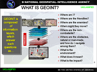
In the United States, geospatial intelligence (GEOINT) is intelligence about the human activity on earth derived from the exploitation and analysis of imagery, signals, or signatures with geospatial information. GEOINT describes, assesses, and visually depicts physical features and geographically referenced activities on the Earth. GEOINT, as defined in US Code, consists of imagery, imagery intelligence (IMINT) and geospatial information.

<span class="mw-page-title-main">519th Military Intelligence Battalion (United States)</span> Military unit

The 519th Military Intelligence Battalion is a unit of the United States Army.

<span class="mw-page-title-main">Delaware Army National Guard</span> Component of the US Army and military of the state of Delaware

The Delaware Army National Guard is a component of the United States Army and the United States National Guard. National coordination of various state National Guard units are maintained through the National Guard Bureau.

<span class="mw-page-title-main">223rd Military Intelligence Battalion (United States)</span> Military unit

The 223rd Military Intelligence Battalion is a military intelligence battalion subordinate to the 300th Military Intelligence Brigade and part of the California Army National Guard.

<span class="mw-page-title-main">United States Army Intelligence and Security Command</span> Unit of the US Army

The United States Army Intelligence and Security Command (INSCOM) is a direct reporting unit that conducts intelligence, security, and information operations for United States Army commanders, partners in the Intelligence Community, and national decision-makers. INSCOM is headquartered at Fort Belvoir, Virginia.

<span class="mw-page-title-main">249th Engineer Battalion (United States)</span> Military unit

The 249th Engineer Battalion (United States) is a versatile power generation battalion assigned to the U.S. Army Corps of Engineers that provides commercial-level power to military units and federal relief organizations during full-spectrum operations. Additionally, the commander serves as the Commandant of the U.S. Army Prime Power School, the institution responsible for the development of Army and Navy power generation specialists.

The Army Geospatial Center (AGC) is a Major Subordinate Command of the United States Army Corps of Engineers. It is located in Alexandria, Virginia, within the Humphreys Engineering Center adjacent to the Fort Belvoir military reservation.

<span class="mw-page-title-main">1st Brigade Combat Team, 10th Mountain Division (United States)</span> Infantry Brigade Combat Team of the United States Army

The 1st Brigade Combat Team, 10th Mountain Division is an active Infantry Brigade Combat Team of the United States Army based at Fort Drum in New York. The brigade headquarters carries the lineage of the 10th Mountain Division's original headquarters company, and served as such in World War II, and in peacetime at Fort Riley, Fort Benning, and West Germany in the 1940s and 1950s.

<span class="mw-page-title-main">302nd Military Intelligence Battalion (United States)</span> Military unit

The 302nd Military Intelligence Battalion, whose unit crest portrays the "sly fox", evolved from the 3252d Signal Service Company which was activated in England on 1 April 1944.

<span class="mw-page-title-main">United States Army Cyber Command</span> Information dominance and cyberspace

U.S. Army Cyber Command (ARCYBER) conducts information dominance and cyberspace operations as the Army service component command of United States Cyber Command.

<span class="mw-page-title-main">319th Military Intelligence Battalion (United States)</span> Military unit

The 319th Military Intelligence Battalion is a military intelligence battalion in the United States Army and is part of the 525th Military Intelligence Brigade (Expeditionary).

<span class="mw-page-title-main">Robert Cardillo</span> American intelligence official

Robert Cardillo is a Distinguished Fellow at Georgetown University’s Center for Security and Emerging Technology. Prior to this appointment, he was the sixth Director of the National Geospatial-Intelligence Agency and was sworn in October 3, 2014. He was previously selected by Director of National Intelligence James Clapper to serve as the first Deputy Director of National Intelligence for Intelligence Integration in September 2010. Clapper said in a statement that the position would "elevate information sharing and collaboration" between those who collect intelligence and those who analyze it. Cardillo previously served as deputy director of the Defense Intelligence Agency (DIA). Prior to that, he served as the deputy director for Analysis, DIA, and Director, Analysis and Production, National Geospatial-Intelligence Agency (NGA).

Geographic information systems (GIS) play a constantly evolving role in geospatial intelligence (GEOINT) and United States national security. These technologies allow a user to efficiently manage, analyze, and produce geospatial data, to combine GEOINT with other forms of intelligence collection, and to perform highly developed analysis and visual production of geospatial data. Therefore, GIS produces up-to-date and more reliable GEOINT to reduce uncertainty for a decisionmaker. Since GIS programs are Web-enabled, a user can constantly work with a decision maker to solve their GEOINT and national security related problems from anywhere in the world. There are many types of GIS software used in GEOINT and national security, such as Google Earth, ERDAS IMAGINE, GeoNetwork opensource, and Esri ArcGIS.

<span class="mw-page-title-main">John Kimmons</span> United States Army general

John Frederick "Jeff" Kimmons is a retired American lieutenant general, who served as United States Army Assistant Chief of Staff for Intelligence, Commanding General, United States Army Intelligence and Security Command and chief of staff to the Director of National Intelligence. He was instrumental in the development of Army Field Manual, FM 2-22.3, Human Intelligence Collector Operations, which was the Army's response to actions at Abu Ghraib prison. Kimmons retired from active service on December 1, 2010, after 35 years.

<span class="mw-page-title-main">470th Military Intelligence Brigade (United States)</span> American military intelligence unit

The 470th Military Intelligence Brigade is a unit of the United States Army and subordinate to the U.S. Army Intelligence and Security Command. Its mission is to provide tailored, multi-disciplined intelligence and counter-intelligence in support of United States Army South (ARSOUTH) and United States Southern Command (USSOUTHCOM). The 470th is headquartered at Fort Sam Houston, Texas with subordinate battalions located in Texas and Florida. Elements of the 470th have participated in Operation Just Cause and have deployed in support of Operation Iraqi Freedom and Operation Enduring Freedom.

<span class="mw-page-title-main">525th Expeditionary Military Intelligence Brigade</span> Military unit

The 525th Expeditionary Military Intelligence Brigade (Expeditionary) is a unit of the United States Army specializing in the acquisition and analysis of information with potential military value. On 28 October 2014, the unit was reflagged from the "525th Battlefield Surveillance Brigade" to an expeditionary military intelligence brigade, the first of its kind.

<span class="mw-page-title-main">502nd Military Intelligence Battalion</span>

The 502nd Military Intelligence Battalion is a military intelligence unit of the United States Army.

<span class="mw-page-title-main">203rd Military Intelligence Battalion</span> Technical intelligence unit of US Army

The 203rd Military Intelligence Battalion (Technical Intelligence) is the sole technical intelligence (TECHINT) collection and foreign material exploitation unit of the United States Department of Defense and a battalion in the United States Army Reserve. The 203rd obtains and exploits captured enemy materials, maintains one of the premier test and evaluation inventories of adversary equipment and weaponry in the US military, and supports specialized tasking including counter-terrorism, special reconnaissance, and direct action missions. Much of the units work is conducted in close collaboration with the National Ground Intelligence Center. The battalion's intelligence products provide TECHINT support to INSCOM, the Defense Intelligence Enterprise, the broader US Intelligence Community (IC), the Five Eyes, NATO, and foreign allies and partners.

References

  1. 1 2 3 4 5 6 "Army GEOINT: A Team Sport". Trajectory Magazine. 2018-01-16. Retrieved 2021-11-04.
  2. Porte, Craig (July 2017). "Military Intelligence Programs: Fashioning Technically Proficient Intelligence Leaders" (PDF). Military Intelligence Professional Bulletin. 43 (3): 10–14.
  3. "INSCOM, 1ST IO, Army GEOINT Battalion team up for Trunk or Treat fun". www.army.mil. Retrieved 2021-11-04.
  4. "Joint Publication 2-03: Geospatial Intelligence in Joint Operations" (PDF). United States Army . July 5, 2017. Archived from the original (PDF) on January 19, 2022. Retrieved November 4, 2021.
  5. BAE Systems (January 15, 2021). "BAE Systems Geoint Data Analyst Vacancy".
  6. 1 2 3 4 Wilder, Matthew (June 2011). "Geospatial Intelligence in Tactical Operations and Planning" (PDF). Infantry . Fort Benning, Georgia. 100 (3): 11–14. ISSN   0019-9532.
  7. 1 2 3 4 "3d Military Intelligence Center". Military Intelligence Professional Bulletin. 35 (3): 57. July 2009.
  8. Drew, Alyssa. "Alyssa Drew Resume" (PDF).
  9. Drew, Alyssa. "Alyssa Drew Resume" (PDF).
  10. 1 2 Anderson, Adrienne (July 26, 2018). "Army GEOINT Battalion gets new leader". The Belvoir Eagle. p. A5.

PD-icon.svg This article incorporates public domain material from websites or documents of the United States Army.