Girard, Pennsylvania

Last updated
Girard, Pennsylvania
Girard main street.jpg
Main Street of Girard
Erie County Pennsylvania incorporated and unincorporated areas Girard highlighted.svg
Location in Erie County and the U.S. state of Pennsylvania.
Coordinates: 42°0′21″N80°19′17″W / 42.00583°N 80.32139°W / 42.00583; -80.32139
CountryUnited States
State Pennsylvania
County Erie
Government
  MayorRobert Kremenik [1]
Area
[2]
  Total2.36 sq mi (6.12 km2)
  Land2.34 sq mi (6.07 km2)
  Water0.02 sq mi (0.05 km2)
Elevation
[3] (center of borough)
777 ft (237 m)
Highest elevation
[3] (southeast corner of borough)
870 ft (270 m)
Lowest elevation620 ft (190 m)
Population
 (2020) [4]
  Total2,993
  Density1,276.88/sq mi (493.11/km2)
Time zone UTC-5 (EST)
  Summer (DST) UTC-4 (EDT)
ZIP code
16417
Area code 814
Website girardboroughpa.us

Girard is a borough in Erie County, Pennsylvania, United States. The population was 2,994 at the 2020 census. [5] It is part of the Erie Metropolitan Statistical Area.

Contents

History

Girard's history began with a petition to "Township Status" in 1832 by reassigning lands previously allocated to neighboring municipalities (Springfield, Fairview, and Elk Creek). The name is in honor of Stephen Girard, a banking tycoon of the late 1700s and early 1800s. [6] [7] Stephen Girard, a resident of Philadelphia at that time, was chosen for a variety of reasons. He owned much of the neighboring Springfield Township, and had been admired by the residents in the region. Additionally, Girard officials had been lobbying with Stephen Girard's foundation, upon his death in 1831, to be the site of the bequeathed Girard College. Despite this attempt, his family and will executors chose to establish the boarding school in Philadelphia where Stephen Girard had a long-standing tradition as a local philanthropist.

Geography

Girard is located in western Erie County at 42°0′21″N80°19′17″W / 42.00583°N 80.32139°W / 42.00583; -80.32139 (42.005954, -80.321481). [8] It is bordered to the northwest by the borough of Lake City and on all other sides by Girard Township.

According to the United States Census Bureau, the borough has a total area of 2.4 square miles (6.1 km2), of which 0.02 square miles (0.05 km2), or 0.81%, is water. [9] Elk Creek roughly follows the southwest border of the borough as it flows northwest to Lake Erie.

U.S. Route 20 passes through the borough as Main Street, leading northeast 4 miles (6 km) to Fairview and 15 miles (24 km) to Erie, and southwest 13 miles (21 km) to Conneaut, Ohio. [10]

Demographics

Historical population
CensusPop.Note
1850 400
1860 61654.0%
1870 70414.3%
1880 703−0.1%
1890 626−11.0%
1900 95452.4%
1910 1,16522.1%
1920 1,2426.6%
1930 1,55425.1%
1940 1,73211.5%
1950 2,14123.6%
1960 2,45114.5%
1970 2,6136.6%
1980 2,6150.1%
1990 2,87910.1%
2000 3,1649.9%
2010 3,104−1.9%
2020 2,994−3.5%
2021 (est.)2,979 [5] −0.5%
Sources: [11] [12] [13] [4]

As of the census [12] of 2000, there were 3,164 people, 1,226 households, and 863 families residing in the borough. The population density was 1,345.0 inhabitants per square mile (519.3/km2). There were 1,269 housing units at an average density of 539.4 per square mile (208.3/km2). The racial makeup of the borough was 98.70% White, 0.38% African American, 0.28% Native American, 0.19% Asian, 0.22% from other races, and 0.22% from two or more races. Hispanic or Latino of any race were 0.60% of the population.

There were 1,226 households, out of which 37.2% had children under the age of 18 living with them, 51.5% were married couples living together, 13.7% had a female householder with no husband present, and 29.6% were non-families. 26.0% of all households were made up of individuals, and 13.2% had someone living alone who was 65 years of age or older. The average household size was 2.57 and the average family size was 3.10.

In the borough the population was spread out, with 29.4% under the age of 18, 6.9% from 18 to 24, 28.8% from 25 to 44, 21.6% from 45 to 64, and 13.4% who were 65 years of age or older. The median age was 36 years. For every 100 females there were 89.8 males. For every 100 females age 18 and over, there were 83.0 males.

The median income for a household in the borough was $33,977, and the median income for a family was $38,936. Males had a median income of $29,975 versus $23,712 for females. The per capita income for the borough was $16,682. About 6.5% of families and 8.3% of the population were below the poverty line, including 13.4% of those under age 18 and 5.2% of those age 65 or over.

Notable people

Related Research Articles

<span class="mw-page-title-main">Fairview, Butler County, Pennsylvania</span> Borough in Pennsylvania, United States

Fairview is a borough in Butler County, Pennsylvania, United States. The population was 198 at the 2010 census. It should not be confused with Fairview in Erie County, which carries the ZIP code 16415.

<span class="mw-page-title-main">Fairview Township, Butler County, Pennsylvania</span> Township in Pennsylvania, United States

Fairview Township is a township in Butler County, Pennsylvania, United States. The population was 1,942 at the 2020 census.

<span class="mw-page-title-main">Spring Township, Crawford County, Pennsylvania</span> Township in Pennsylvania, United States

Spring Township is a township in Crawford County, Pennsylvania, United States. The population was 1,412 at the 2020 census, down from 1,548 at the 2010 census.

<span class="mw-page-title-main">Avonia, Pennsylvania</span> Census-designated place in Pennsylvania, United States

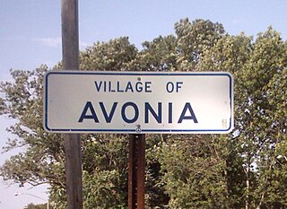
Avonia is an unincorporated community and census-designated place (CDP) in Erie County, Pennsylvania, United States. The population was 1,205 at the 2010 census, down from 1,331 in 2000. It is part of the Erie Metropolitan Statistical Area.

<span class="mw-page-title-main">Cranesville, Pennsylvania</span> Borough in Pennsylvania, United States

Cranesville is a borough in Erie County, Pennsylvania, United States. The population was 572 at the 2020 census. It is part of the Erie Metropolitan Statistical Area.

<span class="mw-page-title-main">Elgin, Pennsylvania</span> Borough in Pennsylvania, United States

Elgin is a borough in Erie County, Pennsylvania, United States. The population was 204 at the 2020 census. It is part of the Erie Metropolitan Statistical Area. Places of recreation include Elgin Community Park. Elgin is home to the oldest borough building in Erie County.

<span class="mw-page-title-main">Elk Creek Township, Erie County, Pennsylvania</span> Township in Pennsylvania, United States

Elk Creek Township is a township in Erie County, Pennsylvania, United States. The population was 1,785 at the 2020 census, down from 1,798 at the 2010 census.

<span class="mw-page-title-main">Fairview Township, Erie County, Pennsylvania</span> Township in Pennsylvania, United States

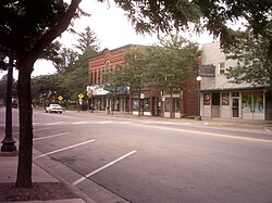
Fairview Township is a township in Erie County, Pennsylvania, United States. Situated on the southern shore of Lake Erie, it was one of the county's sixteen original townships, and was founded in 1797.

<span class="mw-page-title-main">Girard Township, Erie County, Pennsylvania</span> Township in Pennsylvania, United States

Girard Township is a township in Erie County, Pennsylvania, United States. The population was 4,872 at the 2020 census, down from the population of 5,102 at the 2010 census.

<span class="mw-page-title-main">Harborcreek Township, Erie County, Pennsylvania</span> Township in Pennsylvania, United States

¤

<span class="mw-page-title-main">Lake City, Pennsylvania</span> Borough in Pennsylvania, United States

Lake City is a borough in Erie County, Pennsylvania, United States. The population was 2,936 at the 2020 census. It is part of the Erie Metropolitan Statistical Area.

<span class="mw-page-title-main">McKean, Pennsylvania</span> Borough in Pennsylvania, United States

McKean is a borough in Erie County, Pennsylvania. The population was 475 at the time of the 2020 census. It is part of the Erie–Meadville combined statistical area. McKean was known as "Middleboro" until it officially changed its name in 1970.

<span class="mw-page-title-main">McKean Township, Erie County, Pennsylvania</span> Township in Pennsylvania, United States

McKean Township is a township in Erie County, Pennsylvania, United States. The population was 4,435 at the 2020 census, up from 4,409 at the 2010 census, down from 4,619 in 2000.

<span class="mw-page-title-main">North East Township, Erie County, Pennsylvania</span> Township in Pennsylvania, United States

North East Township is a township in Erie County, Pennsylvania, United States. The population was 6,530 at the 2020 census, up from 6,315 at the 2010 census, down from 7,702 in 2000.

<span class="mw-page-title-main">Platea, Pennsylvania</span> Borough in Pennsylvania, United States

Platea is a borough in Erie County, Pennsylvania, United States. The population was 443 at the 2020 census.

<span class="mw-page-title-main">Springfield Township, Erie County, Pennsylvania</span> Township in Pennsylvania, United States

Springfield Township is a township in Erie County, Pennsylvania, United States. The population was 3,077 at the 2020 census, down from 3,425 at the 2010 census.

<span class="mw-page-title-main">Wattsburg, Pennsylvania</span> Borough in Pennsylvania, United States

Wattsburg is a borough in Erie County, Pennsylvania, United States. The population was 352 at the 2020 census. It is part of the Erie Metropolitan Statistical Area.

<span class="mw-page-title-main">Wesleyville, Pennsylvania</span> Borough in Pennsylvania, United States

Wesleyville is a borough in Erie County, Pennsylvania, United States. The population was 3,229 at the 2020 census, down from 3,341 in 2010. It is part of the Erie Metropolitan Statistical Area.

<span class="mw-page-title-main">Fredonia, Pennsylvania</span> Borough in Pennsylvania, United States

Fredonia is a borough in central Mercer County, Pennsylvania, United States. The population was 435 at the 2020 census. It is part of the Youngstown–Warren metropolitan area.

<span class="mw-page-title-main">Fairview Township, York County, Pennsylvania</span> Township in Pennsylvania, United States

Fairview Township is a township in York County, Pennsylvania, United States. The population was 17,436 at the 2020 census.

References

  1. "Erie County Election Results". Archived from the original on 2018-01-17. Retrieved 2018-01-17.
  2. "ArcGIS REST Services Directory". United States Census Bureau. Retrieved October 12, 2022.
  3. 1 2 3 "Girard Junction Topo Map, Erie County PA (Fairview Area)". TopoZone. Locality, LLC. Retrieved 2 September 2019.
  4. 1 2 "Census Population API". United States Census Bureau. Retrieved Oct 12, 2022.
  5. 1 2 Bureau, US Census. "City and Town Population Totals: 2020-2021". Census.gov. US Census Bureau. Retrieved 19 July 2022.
  6. Gannett, Henry (1905). The Origin of Certain Place Names in the United States. Govt. Print. Off. pp.  138.
  7. "Girard Chamber of Commerce; History of Girard". Archived from the original on 2016-08-25. Retrieved 2014-01-27.
  8. "US Gazetteer files: 2010, 2000, and 1990". United States Census Bureau. 2011-02-12. Retrieved 2011-04-23.
  9. "Geographic Identifiers: 2010 Demographic Profile Data (G001): Girard borough, Pennsylvania". American Factfinder. U.S. Census Bureau. Archived from the original on February 13, 2020. Retrieved March 15, 2016.
  10. "About Us". Girard Township. Retrieved 2023-07-07.
  11. "Census of Population and Housing". U.S. Census Bureau. Retrieved 11 December 2013.
  12. 1 2 "U.S. Census website". United States Census Bureau . Retrieved 2008-01-31.
  13. "Incorporated Places and Minor Civil Divisions Datasets: Subcounty Resident Population Estimates: April 1, 2010 to July 1, 2012". Population Estimates. U.S. Census Bureau. Archived from the original on 11 June 2013. Retrieved 11 December 2013.
  14. "Charlotte Elizabeth Battles-A Woman Ahead of Her Time". Hagen History Center. Retrieved 2021-03-04.