The Molonglo River, a perennial river that is part of the Murrumbidgee catchment within the Murray–Darling basin, is located in the Monaro and Capital Country regions of New South Wales and the Australian Capital Territory, in Australia.

The Monaro Highway is a highway in Victoria, New South Wales, and the Australian Capital Territory, in Australia.

The District of Belconnen is one of the original eighteen districts of the Australian Capital Territory (ACT), used in land administration. The district is subdivided into 27 divisions (suburbs), sections and blocks. The district of Belconnen is largely composed of Canberra suburbs.

The District of Gungahlin is one of the original eighteen districts of the Australian Capital Territory used in land administration. Gungahlin Region is one of fastest growing regions within Australia. The district is subdivided into divisions (suburbs), sections and blocks. Gungahlin is an Aboriginal word meaning either "white man's house" or "little rocky hill".
Mitchell Freeway is a 36-kilometre-long (22 mi) freeway in the northern suburbs of Perth, Western Australia, linking central Perth with the city of Joondalup. It is the northern section of State Route 2, which continues south as Kwinana Freeway and Forrest Highway. Along its length are interchanges with several major roads, including Graham Farmer Freeway and Reid Highway. The southern terminus of the Mitchell Freeway is at the Narrows Bridge, which crosses the Swan River, and the northern terminus is at Hester Avenue, Clarkson, a suburb within the City of Wanneroo.
Aranda is a suburb in the district of Belconnen, in the Australian capital city of Canberra. Located at the western foot of Black Mountain and bounded on two sides by nature park, the suburb is characterised by its bush setting. During the planning and development of the suburb, a large proportion of large native trees – predominantly eucalypts – were left in place.
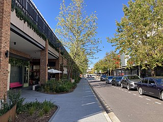
Woden Town Centre is the main commercial centre of the district of Woden Valley in Canberra, Australia. It is located in the Canberra suburb of Phillip. The town centre has a variety of shops and amenities, including office blocks that house Australian departments, and shopping centres like Westfield Woden. The Woden Valley itself was the first satellite city, separate from the Canberra Central district.
Kings Avenue is a road in Canberra which goes between New Parliament House, across Lake Burley Griffin at the Kings Avenue Bridge, to Russell near the Australian-American Monument..

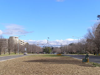
Parkes Way is a major road in Canberra, Australia, which runs east–west between Kings Avenue and the Glenloch Interchange. At Glenloch Interchange it intersects with William Hovell Drive, Tuggeranong Parkway and Caswell Drive. The road is freeway standard from the Commonwealth Avenue overpass to Glenloch Interchange. Parkes Way is named for prominent Australian federalist, Sir Henry Parkes.

Tuggeranong Parkway is an 11-kilometre-long (6.8 mi) major highway in Canberra, Australia. Often referred to as "The Parkway" by locals, Tuggeranong Parkway links Civic to the southern Canberra metro district of Tuggeranong, and is a bypass road to the Woden Valley-Weston Creek district of Canberra. It also links to the Glenloch Interchange, where roads such as Caswell Drive connect to Belconnen.

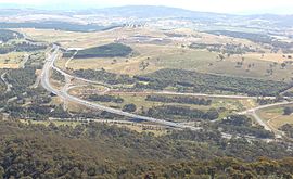
Gungahlin Drive Extension is a freeway grade road, located in the Belconnen district of Canberra, Australia. It is 8.3 kilometres long and extended the previously existing Gungahlin Drive from the Barton Highway in the district of Gungahlin to the Glenloch Interchange to connect with the Tuggeranong Parkway, Parkes Way, and William Hovell Drive. Early in the planning stages, the GDE was to instead be designated the John Dedman Parkway.

The Canberra Times Marathon Festival is an annual marathon held in the city of Canberra, the capital of Australia. The marathon, which was established in 1976, is said to be the oldest city marathon in Australia. It often takes place early in April.

Mounts Bay Road is a major road in Perth, Western Australia, extending southwest from the central business district along the north bank of the Swan River, at the base of Kings Park.
22nd Street is an arterial road in Saskatoon, Saskatchewan. It starts out as 22nd Street East in the Central Business District. Going west it passes the Midtown Plaza and TCU Place. At the intersection with Idylwyld Drive, it becomes 22nd Street West. Through the inner city neighbourhoods of Caswell Hill, Riversdale, Westmount, and Pleasant Hill, it contains a mixture of commercial and residential development. It then connects with Circle Drive via an interchange. Next to the interchange is the Confederation Mall. Across from that is a Real Canadian Superstore. From there is passes by the neighbourhoods of Pacific Heights, Blairmore, and Kensington. The road then heads out of the city and continues on as Highway 14.
Majura Parkway is a 11.5-kilometre-long (7.1 mi) north–south parkway located in the Majura district of the Australian Capital Territory (ACT). It links the northern end to the Federal Highway and Horse Park Drive at the edge of Gungahlin district, and the southern end to the Monaro Highway in Pialligo.

Yarra Glen is a major grade separated arterial road in Canberra. It is 3 km (1.9 mi) in length connects South Canberra to the Woden Valley district. It links at its northern end to Adelaide Avenue, and at its southern end to Melrose Drive and Yamba Drive via a large roundabout. It was designed to have no traffic lights nor cross roads on it.

The Sydney Gateway is an under-construction major road interchange between the WestConnex and the airport terminals of Sydney Airport. Construction began in early 2021 and is expected to open in December 2024. It was originally planned to open in late 2023 in conjunction with the M4–M5 Link. The Sydney Gateway will also be constructed in conjunction with the duplication of the nearby Port Botany freight rail line, which is managed by the Australian Rail Track Corporation.

Acton Tunnel is a short road tunnel in Acton, Australian Capital Territory which opened in 1979. It carries the dual carriageway Parkes Way under a hill. The tunnel also comprises two upper levels, which have been used as an archival repository and car park by the Australian National University (ANU).
Marine Drive is the name for three major roadways in Greater Vancouver, British Columbia, Canada. The roads are known for running parallel to major bodies of water, with some sections being a major arterial road, while other serve local traffic. Marine Way is the name applied to a section of Marine Drive that was bypassed in the early 1980s.