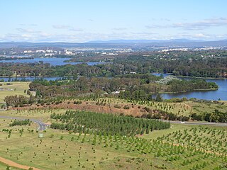
Lake Burley Griffin is an artificial lake in the centre of Canberra, the capital of Australia. It was completed in 1963 after the Molonglo River, which ran between the city centre and Parliamentary Triangle, was dammed. It is named after Walter Burley Griffin, the American architect who won the competition to design the city of Canberra.

Capital Hill is the location of Parliament House, Canberra, at the south apex of the land axis of the Parliamentary Triangle.

Barton is a suburb of Canberra, Australian Capital Territory, Australia. At the 2021 census, Barton had a population of 1,946 people.
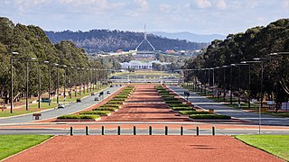
Anzac Parade is a significant road and thoroughfare in the Australian capital Canberra, used for ceremonial occasions and the site of many major military memorials.
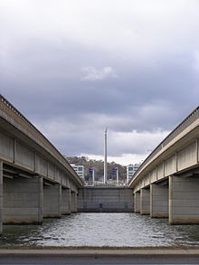
The Australian Merchant Navy Memorial is a memorial honouring the Australian Merchant Navy's involvement in World War I and World War II. It is located in Kings Park, on the northern shore of Lake Burley Griffin in Canberra, the national capital city of Australia. Its location at the shore of the lake represent's the Merchant Navy's relationship with water. It was unveiled on 7 October 1990 by Bill Hayden AC, Governor-General of Australia. A memorial service is held on the first Sunday on or after 21 October each year.

The National Triangle, which is referred to as the Parliamentary Triangle, is the ceremonial precinct of Canberra, containing some of Australia's most significant buildings. The National Triangle is formed by Commonwealth, Kings and Constitution Avenues. Buildings within the National Triangle have been located and designed intentionally for visual effect, and those of national significance are popular tourist attractions.

Commonwealth Place is located on the southern shore of Lake Burley Griffin, Canberra. It lies along the ‘water axis’ running along the lake from Black Mountain. Commonwealth Place is the location of the Gallery of Australian Design, Reconciliation Place, a restaurant and Speakers Square. Walter Burley Griffin, the architect who designed Canberra, envisaged that the area would be the site of a "water gate" which would have a terrace above it, providing a "forum for the people". Griffin's vision was for a long time left unrecognised but as of 2005 the area was being developed to reflect the original plan.

City Hill is a park located in Canberra, Australia, on one of the points of the Parliamentary Triangle, a feature of Walter Burley Griffin's plan for the city. The park is surrounded by Vernon Circle, at the south end of Northbourne Avenue, but beyond Vernon Circle it is further surrounded by the concentric London Circuit, and the area between Vernon Circle and London Circuit can also be seen as part of the hill. City Hill is an integral part of the city centre design. To the south of the hill Northbourne Avenue becomes Commonwealth Avenue, and further along is Commonwealth Avenue bridge.

Telopea Park is one of the oldest parks in Canberra, Australia. The name of the park is from Walter Burley Griffin's original plan for Canberra where he planned Telopea Park at the end of Sydney Avenue. The park is named after the floral emblem of New South Wales, also known as the Waratah. Griffin planned that the state capital city avenues were terminated with a park named after the generic botanical name for a native plant from that particular state. The park covers 0.079 km².

Kings Park is a park in Canberra, Australia on the shore of Lake Burley Griffin.
Yarramundi Reach is a small peninsula on the western end of Lake Burley Griffin, in the Australian Capital Territory, close to Scrivener Dam. It is also the name for the area of water on Lake Burley Griffin between it and Weston Park.

Commonwealth Avenue is a major road in Canberra, Australian Capital Territory, Australia. It connects Civic with South Canberra. Specifically, it runs between City Hill and Capital Hill.

Parkes Way is a major road in Canberra, Australia, which runs east-west between Kings Avenue and the Glenloch Interchange. At Glenloch Interchange it intersects with William Hovell Drive, Tuggeranong Parkway, and Caswell Drive. The road is freeway standard from the Commonwealth Avenue overpass to Glenloch Interchange. Parkes Way is named for prominent Australian federalist, Sir Henry Parkes.

The Canberra Street Circuit was a temporary street circuit located in Canberra, Australian Capital Territory, Australia. It hosted the Canberra 400 for the V8 Supercars series from 2000 to 2002.

The history of Lake Burley Griffin, an artificial body of water in Canberra, the capital of Australia, is highly complex. Following its initial design in the 1910s, extensive political disputes occurred until it was finally built in the 1960s.

Constitution Avenue in a street in Canberra, the capital of Australia.
The Immigration Bridge was a proposed footbridge in Canberra, the capital of Australia. It was proposed that it be built between the National Museum of Australia and Lennox Gardens on the south shore of the West Basin of Lake Burley Griffin, in the centre of the city.

State Circle is a circular road surrounding Capital Hill in the centre of Canberra, Australia's capital city. It is the outermost of the three concentric roads on the hill, with Capital Circle and Parliament Drive located within State Circle. Capital Circle is a bi-directional four-lane road with most intersections being signalised and at-grade. The speed limit is 70 km/h.

Yarra Glen is a major grade separated arterial road in Canberra. It is 3 km (1.9 mi) in length connects South Canberra to the Woden Valley district. It links at its northern end to Adelaide Avenue, and at its southern end to Melrose Drive and Yamba Drive via a large roundabout. It was designed to have no traffic lights nor cross roads on it.
Scott's Crossing Road was a former roadway connecting north and south Canberra, across the Molonglo River floodplain. It was named after John Scott, who was an early settler in the region, and whose homestead was located at its southern end. It was submerged by the filling of Lake Burley Griffin.