Barton, Australian Capital Territory

Last updated

Barton
Canberra,  Australian Capital Territory
Hotel Kurrajong in Barton (2).jpg
Hotel Kurrajong
Australia Capital Territory location map.svg
Red pog.svg
Barton
Coordinates 35°18′28″S149°08′04″E / 35.30778°S 149.13444°E / -35.30778; 149.13444
Population1,946 (2021 census) [1]
 • Density880.5/km2 (2,281/sq mi)
Established1922
Gazetted 20 September 1928
Postcode(s) 2600
Elevation565 m (1,854 ft)
Area2.21 km2 (0.9 sq mi)
Location
District South Canberra
Territory electorate(s) Kurrajong
Federal division(s) Canberra
Suburbs around Barton:
Parkes Parkes Kingston
Capital Hill Barton Kingston
Forrest Forrest Forrest

Barton (postcode: 2600) is a suburb of Canberra, Australian Capital Territory, Australia. At the 2021 census, Barton had a population of 1,946 people. [1]

Contents

Barton is adjacent to Capital Hill. It contains the Department of Prime Minister and Cabinet, Attorney-General's Department, Department of Foreign Affairs and Trade and several other Commonwealth government departments.

On Kings Avenue is the controversial Edmund Barton Building, which was made a heritage listed building in 2005, but its modernist design has often been criticised.

The boundary of Barton runs along Telopea Park East in the south east. On the east side it surrounds the East Basin of Lake Burley Griffin. In the north east the boundary is Morshead Drive. The boundary continues along Kings Avenue all the way to State Circle. State Circle forms the boundary with Capital Hill to the west. The boundary then extends along the centre of Sydney Avenue, and finally along New South Wales Crescent back to Telopea Park.

History

Barton Housing Precinct, Gipps Street Gipps Street, Barton, ACT.JPG
Barton Housing Precinct, Gipps Street
House in Telopea Park West Telopea Park West, Barton, ACT 2.JPG
House in Telopea Park West
Brassey Hotel Brassey Hotel in Barton.jpg
Brassey Hotel

Settlement of Barton began in 1922. The first stage of the heritage-listed Barton Housing Precinct began in 1926 and 1927. It was named after Sir Edmund Barton, the father of the White Australia Policy, in 1928. Streets in Barton are named after Governors. [2]

The following areas are heritage listed:

The former Patent Office and the Edmund Barton building are outside the jurisdiction of the ACT Heritage Council but are recognised and protected in the Commonwealth Heritage List. [8] [9]

Suburb amenities

The Edmund Barton Building Edmund barton building canberra.JPG
The Edmund Barton Building

Barton mainly contains government or national institutions and so has few commercial areas such as shops. Barton contains the ACT Hospice, named Clare Holland House and located at the east end of Lake Burley Griffin. On Blackall Street is St Mark's National Theological Centre, a partner in Charles Sturt University School of Theology. The Australian Centre for Christianity and Culture is located next to St Mark's. The Australian Federal Police College is on Brisbane Avenue. Telopea Park School is on New South Wales Crescent.

Brassey Hotel was named after Sir Thomas Brassey, Governor of Victoria. It was originally a guest house for mid level government officials and for Members of Parliament. [4] [10]

The Hotel Kurrajong, favored by Ben Chifley and the location of his death in 1951, is also located in the suburb. [5] [11] It is now occupied by the Australian International Hotel School.

Parks in Barton include Telopea Park, York Park, Bowen Park which is on the south shore of Lake Burley Griffin, and Grevillea Park on the north side of the lake.

Demographics

Apartments in Sydney Avenue Realm Apartments, Barton 1.JPG
Apartments in Sydney Avenue

At the 2021 census, the population of Barton was 1,946. Aboriginal and Torres Strait Islander people made up 1.0% of the population. 62.5% of the population were born in Australia. Only 6.3% of dwellings were separate houses (compared to the Australian average of 72.3%) and 3.0% were semi-detached, row or terrace houses (Australian average: 12.6%), while 90.9% were flats, units or apartments (Australian average: 14.2%). 46.5% of the population were professionals, compared to the Australian average of 24.0%. Notably 31.6% worked in central government administration, compared to the Australian average of 1.1% and the ACT-wide average of 17.1%. The median weekly personal income for people aged 15 years was $1,775, compared to the median Australian income of $805. Barton is favoured by young adults with 26.4% of its population in the 25- to 34-year-old age group (compared to the Australian average of 14.3%). The suburb has few children under 15: 7.2%, compared to 18.2% Australia-wide. 46.6% of the dwellings are occupied by single person households, compared to the Australian average of 25.6%. 47.2% of the population had no religion and 13.3% did not state their religion, while 13.3% were Catholic and 8.8% were Anglican. [1]

Politics

Barton is located within the federal electorate of Canberra, which is currently represented by Alicia Payne in the House of Representatives. In the ACT Legislative Assembly, Barton is part of the electorate of Kurrajong, which elects five members on the basis of proportional representation, currently two Labor, two Greens and one Liberal. [12]

Geology

A patch of Ordovician Pittman Formation greywacke outcrops in the south along Canberra Avenue. Silurian Canberra Formation, calcareous Shale is under most of the suburb. Tertiary river gravels are found in the Blackall Street area. [13]

Education

Barton residents get preference for: [14]

Related Research Articles

<span class="mw-page-title-main">North Canberra</span> Place in Australian Capital Territory

North Canberra, or the Inner North, is a subdivision of Canberra Central in the Australian Capital Territory in Australia. Comprising 14 suburbs. At the 2021 census, it had 26,699 dwellings housing 61,188 people of the 453,324 people in the Australian Capital Territory. Many of Canberra's oldest dwellings are located on it.

<span class="mw-page-title-main">Civic, Australian Capital Territory</span> Suburb of Canberra, Australian Capital Territory

Civic is the city centre or central business district of Canberra. "Civic" is a common name for the district, but it is also called Civic Centre, City Centre, Canberra City and Canberra, and its official division name is City.

<span class="mw-page-title-main">Yarralumla, Australian Capital Territory</span> Suburb of Canberra, Australia

Yarralumla is a large inner south suburb of Canberra, the capital city of Australia. Located approximately 3.5 km (2.2 mi) south-west of the city, Yarralumla extends along the south-west bank of Lake Burley Griffin from Scrivener Dam to Commonwealth Avenue.

<span class="mw-page-title-main">Reid, Australian Capital Territory</span> Suburb of Canberra, Australia

Reid is a suburb of Canberra, Australian Capital Territory, Australia. With a population of 1,544 at the 2021 census, located directly next to Civic, Reid is one of the oldest suburbs in Canberra. It is named after George Reid, the fourth prime minister of Australia.

<span class="mw-page-title-main">Braddon, Australian Capital Territory</span> Suburb of Canberra, Australia

Braddon is an inner north suburb of Canberra, Australian Capital Territory, Australia located adjacent to the Canberra CBD.

<span class="mw-page-title-main">Turner, Australian Capital Territory</span> Suburb of Canberra, Australia

Turner is a suburb in the Australian city of Canberra, close to Canberra City and the Australian National University.

Forrest is a suburb of Canberra, Australian Capital Territory, Australia. Forrest is named after Sir John Forrest, an explorer, legislator, federalist, Premier of Western Australia, and one of the fathers of the Australian Constitution. Streets in Forrest are named after explorers and governors. According to the Australian Bureau of Statistics Forrest is the second most Socio-Economic advantaged location in Australia after the neighbouring suburb of Barton.

<span class="mw-page-title-main">Capital Hill, Australian Capital Territory</span> City center and the location of Parliament House, Canberra, Australia

Capital Hill is the location of Parliament House, Canberra, at the south apex of the land axis of the Parliamentary Triangle.

<span class="mw-page-title-main">Griffith, Australian Capital Territory</span> Suburb of Canberra, Australia

Griffith is an early inner-south suburb of Canberra, Australian Capital Territory, Australia.

<span class="mw-page-title-main">Kingston, Australian Capital Territory</span> Suburb of Canberra, Australia

Kingston is the oldest and one of the most densely populated suburbs of Canberra, Australian Capital Territory, Australia. The suburb is named after Charles Cameron Kingston, the former Premier of South Australia and minister in the first Australian Commonwealth Government. It is adjacent to the suburbs of Barton, Fyshwick, Griffith and Manuka. The suburb of Kingston is situated about 4 km from the centre of Canberra.

South Canberra, or the Inner South, is a subdivision of Canberra Central in the Australian Capital Territory in Australia.

<span class="mw-page-title-main">Red Hill, Australian Capital Territory</span> Suburb of Canberra, Australia

Red Hill is a suburb of Canberra, Australian Capital Territory, Australia. The suburb is named after the northernmost hill of the ridge to the west of the suburb. The ridge is a reserve and managed as part of the Canberra Nature Park. The hill is an element of the central Canberra design axis.

<span class="mw-page-title-main">Hotel Canberra</span> Hotel in Australia

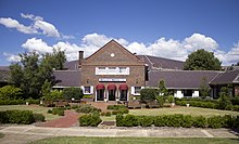
The Hyatt Hotel Canberra - A Park Hyatt Hotel, is a historic hotel in the Australian national capital, Canberra. It is located in the suburb of Yarralumla, near Lake Burley Griffin and Parliament House. It was built to house politicians when the Federal Parliament moved to Canberra from Melbourne in 1927. It was constructed by the contractor John Howie between 1922-1925. Originally opened in 1924 as Hostel No. 1, in 1927 it became known as the Hotel Canberra.

<span class="mw-page-title-main">Public housing in the Australian Capital Territory</span>

Government-owned housing in Canberra and the Australian Capital Territory has a history stemming from the decision to build the National Capital in the bush. In the early years Canberra's housing was entirely government-built and even after private development took over there has been a number of government houses included in almost every new suburb. Typical Canberra public housing is built on a limited number of plans repeated through an area of a suburb, with two or three bedrooms and constructed in unfinished brick veneer. They typically range in size from around 80 m2 to 130 m2. The term Govie is a colloquialism used to describe the typical Canberran government built house.

<span class="mw-page-title-main">Lyneham, Australian Capital Territory</span> Suburb of Canberra, Australia

Lyneham is a suburb of Canberra, Australia in the North Canberra district. It is named after Sir William Lyne, premier of New South Wales from 1899 to 1901. The suburb name was gazetted in 1928, but development did not commence until 1958. The streets of Lyneham are named after artists and people associated with the development of early Canberra.

<span class="mw-page-title-main">Ainslie, Australian Capital Territory</span> Suburb of Canberra, Australia

Ainslie is a suburb of Canberra, Australia in the North Canberra district.

<span class="mw-page-title-main">Telopea Park</span>

Telopea Park is one of the oldest parks in Canberra, Australia. The name of the park is from Walter Burley Griffin's original plan for Canberra where he planned Telopea Park at the end of Sydney Avenue. The park is named after the floral emblem of New South Wales, also known as the Waratah. Griffin planned that the state capital city avenues were terminated with a park named after the generic botanical name for a native plant from that particular state. The park covers 0.079 km².

<span class="mw-page-title-main">Manuka, Australian Capital Territory</span> Neighbourhood of Canberra, Australia

Manuka is an area in the Inner South district of Canberra, Australia covering parts of the suburbs of Griffith and Forrest. Manuka Shops, Manuka Oval, Manuka Swimming Pool, and Manuka Circle take their name from the park in the area.

<span class="mw-page-title-main">O'Connor, Australian Capital Territory</span> Suburb of Canberra, Australia

O'Connor is an affluent suburb of Canberra, Australia in the North Canberra district characterised by its leafy, heritage listed streets. It was named after Richard Edward O'Connor (1851–1912), who was a judge in the High Court and a founder of the Australian constitution. Street names in O'Connor are named after explorers, Australian flora, legislators and pioneers. The suburb name was gazetted on 20 September 1928.

<span class="mw-page-title-main">Hotel Kurrajong</span> Hotel in Canberra, Australia

Hotel Kurrajong Canberra is a heritage-listed hotel located in the Canberra suburb of Barton, Australian Capital Territory, close to Parliament House and national institutions within the Parliamentary Triangle precinct. The Hotel has a strong association with Australia's political history, most notably as the residence of Prime Minister Ben Chifley throughout his parliamentary career, including his term in office from 1945-1949. In 1951, Chifley suffered a fatal heart attack in room 205 at Hotel Kurrajong.

References

  1. 1 2 3 Australian Bureau of Statistics (28 June 2022). "Barton". 2021 Census QuickStats. Retrieved 27 August 2020. OOjs UI icon edit-ltr-progressive.svg
  2. "Place Names". Australian Capital Territory Planning and Land Authority. Archived from the original on 4 February 2014. Retrieved 3 February 2014.
  3. "20012. Barton Housing Precinct (Entry to the ACT Heritage Register)" (PDF). ACT Heritage Council. Retrieved 15 March 2014.
  4. 1 2 "20029. The Brassey Hotel (Entry to the ACT Heritage Register)" (PDF). ACT Heritage Council. Retrieved 15 March 2014.
  5. 1 2 "20113. Hotel Kurrajong (Entry to the ACT Heritage Register)" (PDF). ACT Heritage Council. 23 February 2005. Retrieved 15 March 2014.
  6. "Heritage (Decision about Registration for Telopea Park School, Barton) Notice 2011" (PDF). ACT Heritage Council. 10 March 2011. Retrieved 15 March 2014.
  7. "Heritage (Decision about Registration for Telopea Park, Barton) Notice 2012" (PDF). ACT Heritage Council. 23 February 2012. Retrieved 15 March 2014.
  8. "Heritage (Decision about Provisional Registration of the Former Patent Office Building, Barton) Notice 2013" (PDF). ACT Heritage Council. 25 July 2013. Retrieved 15 March 2014.
  9. "Heritage (Decision about Provisional Registration of the Edmund Barton Building, Barton) Notice 2013" (PDF). ACT Heritage Council. 14 April 2013. Retrieved 15 March 2014.
  10. "History". Brassey Hotel. Retrieved 22 January 2007.
  11. Minney, Karleen (7 February 2014). "A weekend in your suburb: 36 hours in Barton". The Canberra Times. Archived from the original on 7 February 2014.
  12. "List of elected candidates - 2020 Election". ACT Legislative Assembly . Retrieved 27 August 2022.
  13. Henderson G A M and Matveev G, Geology of Canberra, Queanbeyan and Environs 1:50000 1980.
  14. "Priority Enrolment Areas 2015 by Suburb" (Archive). Education Directorate, Australian Capital Territory. Retrieved 8 February 2016.