Kingston, Australian Capital Territory

Last updated

Kingston
Canberra,  Australian Capital Territory
Green Square Kingston November 2018.jpg
Green Square at Kingston shops in November 2018
Australia Capital Territory location map.svg
Red pog.svg
Kingston
Coordinates 35°18′56″S149°08′39″E / 35.31556°S 149.14417°E / -35.31556; 149.14417
Population6,579 (2021 census) [1]
 • Density5,022/km2 (13,010/sq mi)
Established1922
Gazetted 20 September 1928
Postcode(s) 2604
Elevation563 m (1,847 ft)
Area1.31 km2 (0.5 sq mi)
Location
District South Canberra
Territory electorate(s) Kurrajong
Federal division(s) Canberra
Suburbs around Kingston:
Barton Lake Burley Griffin Fyshwick
Barton Kingston Fyshwick
Manuka Griffith Fyshwick

Kingston is the oldest and one of the most densely populated suburbs of Canberra, Australian Capital Territory, Australia. The suburb is named after Charles Cameron Kingston, the former Premier of South Australia and minister in the first Australian Commonwealth Government. [2] It is adjacent to the suburbs of Barton, Fyshwick, Griffith and Manuka. The suburb of Kingston is situated about 4 km from the centre of Canberra.

Contents

History

Eastlake, 1928 Giles street eastlake canberra 1928.jpg
Eastlake, 1928
Kingston industrial area 1950s Kingston150.png
Kingston industrial area 1950s

In the early years of Canberra's development, Eastlake occupied the area now known as Kingston. Eastlake Football and Cricket club is one of the few reminders of Kingston long past. Eastlake was designated as a workers living quarters while the suburb of Forrest was reserved for middle and higher ranking public servants. About 120 portable wooden cottages for construction workers were built at the Causeway in 1925 and 1926. Canberra's first hall for community gatherings and entertainment was at the Causeway where the recreation hall was completed in 1926 with voluntary labour using materials provided by the Federal Capital Commission. After the second world war, housing at the Causeway and Westlake was considered sub-standard. Although all of the original Westlake cottage have been demolished, the Causeway survives with the original temporary wooden cottages now replaced with brick veneer cottages. As it was separated from the rest of the suburb by Wentworth Avenue and was situated to the north of the railway station the Causeway was a distinct district within the suburb of Kingston, however, it is now abutted by the new Kingston foreshore development. [3]

The Causeway is on the edge of a road called the Causeway, which was planned as a dam across the Molonglo River that would back up East Lake, which was planned by Walter Burley Griffin but never built. The cottages at Causeway were designed by HM Rolland and were first erected at Westlake in 1924, then Acton and finally at the Causeway in 1925–1926. The Westlake cottages were sold off from the mid-1950s – last cottage removed in 1965. A number are now in Queanbeyan and down the South Coast. One also sits with a new coat of paint, in River Street, Oaks Estate. A photograph showing one of the cottages on the move is in Westlake One of the Vanished Suburbs of Canberra – Gugler, A. The timber cottages at the Causeway were pulled down. The cottage design, referred to as portable timber cottages, designed by Rolland were based on the cottages erected at Westlake (present site, Block 3, Section 128 Stirling Park, Yarralumla) by Contractor John Howie for his married men – built 1922. He also built nearby 18 or more timber huts for his single men, known as the Hostel Camp. The Burns Club was founded there in 1924. [3]

Heritage listed areas

Former ACTION bus depot Old Kingston Bus Depot.jpg
Former ACTION bus depot
Canberra Baptist Church Canberra Baptist Church March 2015.jpg
Canberra Baptist Church

The following areas are heritage listed:

Current development

High rises flats in Kingston Kingston, ACT high rises.JPG
High rises flats in Kingston

In recent years Kingston has been largely redeveloped with medium-density housing including townhouses and units. Most of Kingston south of Wentworth Avenue is zoned for a predominant height of "3 storeys, with a maximum height of 4 storeys only where it is not the dominant feature of a street frontage", although there are two high-rise blocks north of the shopping centre and the detached houses in three city blocks in the south have heritage protection. [15]

The most recent development is the Kingston Foreshores development in which large numbers of high-value apartments are being built along the foreshores of Lake Burley Griffin. The area had previously been used for industrial purposes and is located between the Canberra railway station and the Kingston Powerhouse. These new developments and the rise of a café society have reformed Kingston as one of the most exclusive suburbs in Canberra. The Kingston Foreshores are zoned for four-story units, but six-storey units are permitted under some conditions in some areas. [15]

Parts of the Kingston Group Centre are now zoned to be redeveloped to a height of 4 storeys (including next to Highgate Lane, which is currently a back alley) and 6 storeys (part of the parking area to the southeast and the site of the former Cusack furniture store). [15]

Suburb amenities

Kingston contains the Kingston Shopping Centre, one of the earliest shopping areas built in Canberra. The northeastern corner of the shopping centre is built around a small park called Green Square. During recent drought years and water restrictions the exotic grass died and were replaced by native grasses that were more drought resistant, but more spiky, discouraging families with children. After a long campaign by local businesses, the exotic grass was reinstituted in early 2014. [16] Kingston is also noted for a lively nightlife and bar scene.

Other places of note in Kingston include the Kingston Powerhouse opened in 1915 and the Canberra railway station. The Old Bus Depot Markets, showing handcrafted goods and foodstuffs, are held on the lakeside every Sunday and have become a regular destination for locals and tourists. [17] Kingston's streets are named after Australia's early European explorers. [2]

Restaurants at Kingston Foreshore Kingston, Australian Capital Territory, December 2016, 04.jpg
Restaurants at Kingston Foreshore
Apartments at Kingston Foreshore Kingston Foreshores 7.JPG
Apartments at Kingston Foreshore
Kingston Boat Harbour Kingston Boat Harbour July 2017.jpg
Kingston Boat Harbour
Howitt Street Kingston, Howitt Street.JPG
Howitt Street

Demographics

At the 2021 census, the population of Kingston was 6,579, including 99 (1.5%) Indigenous persons and 2,967 (66.3%) Australian-born persons. 3.0% of dwellings were separate houses (compared to the Australian average of 72.3%), while 6.4% were semi-detached, row or terrace houses (Australian average: 12.6%) and 90.5% were flats, units or apartments (Australian average: 14.2%). 45.0% of the population were professionals, compared to the Australian average of 24.0%. Notably 25.5% worked in central government administration, compared to the Australian average of 1.1% and the ACT-wide average of 17.1%. 51.8% of the population had no religion, compared to the ACT average of 43.5% and the Australian average of 38.4%. [1]

Major Roads

The major road in Kingston is Wentworth Avenue which carries traffic through the suburb from the northwest to the southeast. Telopea Park East forms the northwest boundary of Kingston. Access to the shopping precinct is via Eyre Street or Giles Street.

Education

Kingston residents get preference for: [18]

Geology

Silurian age Canberra Formation, calcareous Shale is under this suburb, with Tertiary gravels over the top in the Causeway. [19]

Related Research Articles

<span class="mw-page-title-main">Lake Burley Griffin</span> Man-made lake in Canberra, Australia

Lake Burley Griffin is an artificial lake in the centre of Canberra, the capital of Australia. It was completed in 1963 after the Molonglo River, which ran between the city centre and Parliamentary Triangle, was dammed. It is named after Walter Burley Griffin, the American architect who won the competition to design the city of Canberra.

<span class="mw-page-title-main">Civic, Australian Capital Territory</span> Suburb of Canberra, Australian Capital Territory

Civic is the city centre or central business district of Canberra. "Civic" is a common name for the district, but it is also called Civic Centre, City Centre, Canberra City and Canberra, and its official division name is City.

<span class="mw-page-title-main">Yarralumla, Australian Capital Territory</span> Suburb of Canberra, Australia

Yarralumla is a large inner south suburb of Canberra, the capital city of Australia. Located approximately 3.5 km (2.2 mi) south-west of the city, Yarralumla extends along the south-west bank of Lake Burley Griffin from Scrivener Dam to Commonwealth Avenue.

<span class="mw-page-title-main">Reid, Australian Capital Territory</span> Suburb of Canberra, Australia

Reid is a suburb of Canberra, Australian Capital Territory, Australia. With a population of 1,544 at the 2021 census, located directly next to Civic, Reid is one of the oldest suburbs in Canberra. It is named after George Reid, the fourth prime minister of Australia.

<span class="mw-page-title-main">Braddon, Australian Capital Territory</span> Suburb of Canberra, Australia

Braddon is an inner north suburb of Canberra, Australian Capital Territory, Australia located adjacent to the Canberra CBD.

<span class="mw-page-title-main">Turner, Australian Capital Territory</span> Suburb of Canberra, Australia

Turner is a suburb in the Australian city of Canberra, close to Canberra City and the Australian National University.

Forrest is a suburb of Canberra, Australian Capital Territory, Australia. Forrest is named after Sir John Forrest, an explorer, legislator, federalist, Premier of Western Australia, and one of the fathers of the Australian Constitution. Streets in Forrest are named after explorers and governors. According to the Australian Bureau of Statistics Forrest is the second most Socio-Economic advantaged location in Australia after the neighbouring suburb of Barton.

<span class="mw-page-title-main">Barton, Australian Capital Territory</span> Suburb of Canberra, Australia

Barton is a suburb of Canberra, Australian Capital Territory, Australia. At the 2021 census, Barton had a population of 1,946 people.

<span class="mw-page-title-main">Griffith, Australian Capital Territory</span> Suburb of Canberra, Australia

Griffith is an early inner-south suburb of Canberra, Australian Capital Territory, Australia.

<span class="mw-page-title-main">Narrabundah, Australian Capital Territory</span> Suburb of Canberra, Australia

Narrabundah is a leafy, medium density suburb of Canberra, Australian Capital Territory, located in the inner south of the city.

<span class="mw-page-title-main">Public housing in the Australian Capital Territory</span>

Government-owned housing in Canberra and the Australian Capital Territory has a history stemming from the decision to build the National Capital in the bush. In the early years Canberra's housing was entirely government-built and even after private development took over there has been a number of government houses included in almost every new suburb. Typical Canberra public housing is built on a limited number of plans repeated through an area of a suburb, with two or three bedrooms and constructed in unfinished brick veneer. They typically range in size from around 80 m2 to 130 m2. The term Govie is a colloquialism used to describe the typical Canberran government built house.

<span class="mw-page-title-main">Lyneham, Australian Capital Territory</span> Suburb of Canberra, Australia

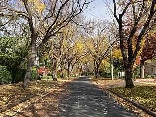
Lyneham is a suburb of Canberra, Australia in the North Canberra district. It is named after Sir William Lyne, premier of New South Wales from 1899 to 1901. The suburb name was gazetted in 1928, but development did not commence until 1958. The streets of Lyneham are named after artists and people associated with the development of early Canberra.

<span class="mw-page-title-main">Dickson, Australian Capital Territory</span> Suburb of Canberra, Australia

Dickson is a suburb in the Inner North of Canberra, Australia. It is named after Sir James R. Dickson (1832–1901) who was a Queensland advocate of Australian Federation and one of the founders of the Australian Constitution. There is no specific theme for street names.

<span class="mw-page-title-main">Ainslie, Australian Capital Territory</span> Suburb of Canberra, Australia

Ainslie is a suburb of Canberra, Australia in the North Canberra district.

<span class="mw-page-title-main">ACTION</span> Public bus operator in Canberra, Australia

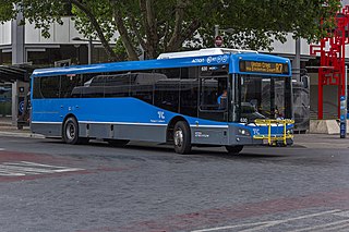
ACTION is a bus operator in Canberra, Australia, and is owned by the Government of the Australian Capital Territory.

<span class="mw-page-title-main">Manuka, Australian Capital Territory</span> Neighbourhood of Canberra, Australia

Manuka is an area in the Inner South district of Canberra, Australia covering parts of the suburbs of Griffith and Forrest. Manuka Shops, Manuka Oval, Manuka Swimming Pool, and Manuka Circle take their name from the park in the area.

<span class="mw-page-title-main">O'Connor, Australian Capital Territory</span> Suburb of Canberra, Australia

O'Connor is an affluent suburb of Canberra, Australia in the North Canberra district characterised by its leafy, heritage listed streets. It was named after Richard Edward O'Connor (1851–1912), who was a judge in the High Court and a founder of the Australian constitution. Street names in O'Connor are named after explorers, Australian flora, legislators and pioneers. The suburb name was gazetted on 20 September 1928.

<span class="mw-page-title-main">Eastlakes, New South Wales</span> Suburb of Sydney, New South Wales, Australia

Eastlakes is an inner southern and eastern suburb of Sydney, in the state of New South Wales, Australia. Eastlakes is located 8 kilometres south of the Sydney central business district, in the local government area of the Bayside Council, Eastlakes is mostly residential with a shopping centre located at Evans Avenue. The residential portion of the suburb falls in the inner south being west of the Eastern Distributor while the non-residential side of the suburb consisting of The Lakes Golf Course and Botany Dams is east of the Eastern Distributor falling within the Eastern Suburbs, south-east of the CBD.

<span class="mw-page-title-main">Canberra railway station</span> Railway station in Canberra, Australia

Canberra railway station is located on the NSW TrainLink Regional Southern Line in the Australian Capital Territory, Australia. It is located in the Canberra suburb of Kingston.

<span class="mw-page-title-main">Kingston Powerhouse</span>

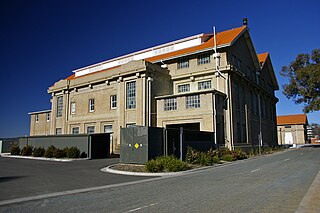
The Kingston Powerhouse is a disused power plant in Canberra, the capital of Australia. It is located in the suburb of Kingston, Australian Capital Territory.

References

  1. 1 2 Australian Bureau of Statistics (28 June 2022). "Kingston". 2021 Census QuickStats. Retrieved 15 July 2022. OOjs UI icon edit-ltr-progressive.svg
  2. 1 2 "Suburb Name search results". ACT Environment and Sustainable Development Directorate. Retrieved 24 February 2014.
  3. 1 2 Emerton, Val (1996). Past Images, Present Voices – Kingston and Thereabouts Through a Box Brownie. Murrumbateman, NSW: Canberra Stories Group. ISBN   0-646-28549-1 . Retrieved 24 February 2014.{{cite book}}: CS1 maint: location missing publisher (link)]
  4. "20044. Kingston/Griffith Housing Precinct (Entry to the ACT Heritage Register)" (PDF). ACT Heritage Council. Retrieved 14 March 2014.
  5. "20048. Kingston Powerhouse Historic Precinct (Entry to the ACT Heritage Register)" (PDF). ACT Heritage Council. Retrieved 14 March 2014.
  6. "20149. Arizona and Himalayan cypresses Trees in Kingston (Entry to the ACT Heritage Register)" (PDF). ACT Heritage Council. Retrieved 14 March 2014.
  7. "Heritage (Decision about Registration of former Transport Depot, Kingston) Notice 2010" (PDF). ACT Heritage Council. 21 October 2010. Retrieved 14 March 2014.
  8. "Major redevelopment for Kingston bus depot site". The Canberra Times . Vol. 64, no. 20, 128. Australian Capital Territory, Australia. 22 May 1990. p. 3. Retrieved 27 March 2023 via National Library of Australia.
  9. Zatschler, Gerhard (21 October 2010). "Heritage (Decision about Registration of former Transport Depot, Kingston) Notice 2010" (PDF). ACT Heritage Register. Retrieved 8 November 2018.
  10. "20 Years at the Former Transport Depot | Old Bus Depot Markets". obdm.com.au. Retrieved 8 November 2018.
  11. Buildings Demolished Fleetline issue 272 May 2001 page 75
  12. Kingston Bus Depot to be transformed Australian Bus Panorama issue 29/4 January 2014 page 22
  13. "20109. Causeway Hall (Entry to the ACT Heritage Register)" (PDF). ACT Heritage Council. 23 February 2005. Retrieved 14 March 2014.
  14. "Heritage (Decision about Registration of the Canberra Baptist Church Precinct, Kingston) Notice 2009 (No 1)" (PDF). ACT Heritage Council. 20 August 2009. Retrieved 14 March 2014.
  15. 1 2 3 "Kingston Precinct Map and Code" (PDF). ACT Environment and Sustainable Development Directorate. 30 May 2014. Retrieved 5 June 2014.
  16. "Kingston celebrates a win with Green Square makeover". The Canberra Times . Retrieved 24 February 2014.
  17. Kelly, Emma (21 February 2014). "A weekend in your suburb: 36 hours in Kingston". The Canberra Times. Archived from the original on 6 March 2014.
  18. "Priority Enrolment Areas 2015 by Suburb Archived 14 February 2016 at the Wayback Machine " (Archive). Education Directorate, Australian Capital Territory. Retrieved 8 February 2016.
  19. Henderson G A M and Matveev G, Geology of Canberra, Queanbeyan and Environs 1:50000 1980.