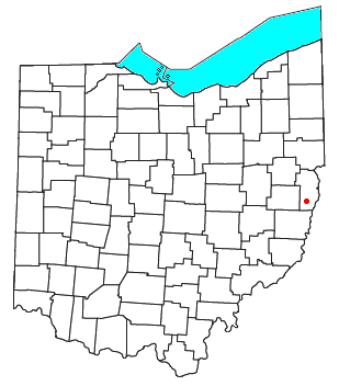
Van Wert County is a county located in the U.S. state of Ohio. As of the 2020 census, the population was 28,931. Its county seat is Van Wert. The county was created on February 12, 1820, and later organized on March 18, 1837. It is named for Isaac Van Wart, one of the captors of John André in the American Revolutionary War.
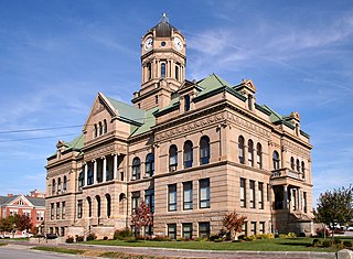
Auglaize County is a county in Northwestern Ohio, United States. As of the 2020 census, the population was 46,442. Its county seat and largest city is Wapakoneta.

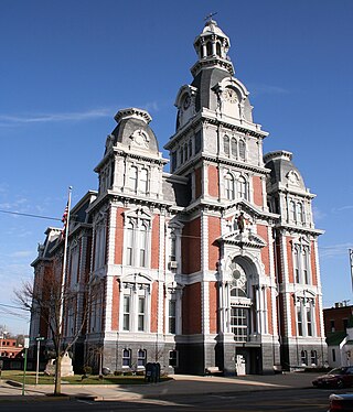
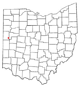
Van Wert is a city in and the county seat of Van Wert County, Ohio, United States. It is located in northwestern Ohio approximately 77 miles (124 km) southwest of Toledo and 34 miles (55 km) southeast of Fort Wayne, Indiana. The population was 11,092 at the 2020 census. It is the principal city of the Van Wert micropolitan area, which is included in the Lima–Van Wert–Wapakoneta combined statistical area.

Venedocia is a village in Van Wert County, Ohio, United States. The population was 140 at the 2020 census. It is included within the Van Wert, Ohio Micropolitan Statistical Area and the Lima-Van Wert-Wapakoneta, OH Combined Statistical Area.

Roselms is an unincorporated community in southwestern Washington Township, Paulding County, Ohio, United States, in the northwestern part of the state. It lies along State Route 114 midway between Grover Hill and Mandale, about 3 miles (5 km) from each. Its elevation is 718 feet (219 m).

Fairhaven is an unincorporated community in eastern Israel Township, Preble County, Ohio, United States. It lies along State Route 177 at its intersection with Israel-Somers Road. Four Mile Creek, which feeds into Acton Lake in southern Preble County, runs on the western edge of Fairhaven. It is located 10½ miles southwest of Eaton, the county seat of Preble County. The community is part of the Dayton Metropolitan Statistical Area. Fairhaven Church and Fairhaven Community Church are both located in Fairhaven along State Route 177. Fairhaven Community Church hosts a free annual Dinner Drama for the community. Fairhaven is home to the historic Bunker Hill house, a stop along the Underground Railroad.

Pyrmont is an unincorporated community in northwestern Perry Township, Montgomery County, Ohio, United States. It centers at the intersection of Brookville–Pyrmont Pike and Sulphur Springs Road, extending to the intersection of Brookville–Pyrmont Pike and Providence Pike. Located in the far west of the county, it lies several miles from the city of Dayton; the nearest city is Brookville, three miles to the northeast. Pyrmont is a part of the Brookville Local School District. Pyrmont, which was on a stagecoach route, was a busy town before Interstate 70 was built near Brookville.
New Somerset is an unincorporated community in northern Knox Township, Jefferson County, Ohio, United States. It lies south of Hammondsville along State Route 213, at 40°30′57″N80°42′21″W.

Hepburn is an unincorporated community in northern Dudley Township, Hardin County, Ohio, United States. It lies at the intersection of County Roads 144 and 227, 7+1⁄2 miles (12.1 km) east of the center of the city of Kenton, the county seat of Hardin County. Along the south side of the community runs the Scioto River. The community is served by the Kenton (43326) post office.

Brokensword is an unincorporated community on the border between the Holmes and Lykens townships of Crawford County, Ohio, United States. Located at the intersection of the concurrent State Routes 19 and 100 with Brokensword Road, it is six miles north and two miles west of the city of Bucyrus, the county seat. Broken Sword Creek flows a short distance to the south of the community.

Bridgeport is an unincorporated community in far western Darby Township, Union County, Ohio, United States. It lies at the intersection of State Route 38 with Orchard Road, midway between the villages of Milford Center and Unionville Center. At Bridgeport, Buck Run meets the Big Darby Creek, which meets the Scioto River at Circleville. It is located 6 miles (9.7 km) south of Marysville, the county seat of Union County.
Greentown is an unincorporated community in eastern Smithfield Township, Jefferson County, Ohio, United States. It lies approximately 2 miles (3.2 km) south of Smithfield, on a small road. Part of the Dry Fork of Short Creek, a stream that meets the Ohio River at Rayland, flows past the community. It is located 11+3⁄4 miles (18.9 km) southwest of Steubenville, the county seat of Jefferson County. The community is part of the Weirton–Steubenville, WV-OH Metropolitan Statistical Area.

Monroe Township is one of twenty townships in Allen County, Indiana, United States. At the 2010 census, the population was 1,927.

Birmingham is an unincorporated community in southeastern Monroe Township, Guernsey County, Ohio, United States. It lies at the intersection of Beal, Birmingham, and Peoli Roads, 3+3⁄4 miles (6.0 km) south of Peoli, 7 miles east-northeast of Kimbolton, and 13 miles (21 km) northeast of central Cambridge, the county seat of Guernsey County. Nearby streams flow southward into Salt Fork Lake, which is included in Salt Fork State Park.
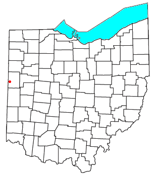
Padua is an unincorporated community in western Washington Township, Mercer County, Ohio, United States. It lies at the intersection of State Route 49 and St. Anthony Road, west of the city of Celina, the county seat of Mercer County. Its elevation is 899 feet (274 m), and it is located at 40°30′30″N84°47′2″W.

Montra is an unincorporated community in Jackson Township, Shelby County, Ohio, United States. Established in the middle of the nineteenth century, the small community is prominent because of a landmark church, Emanuel Lutheran Church of Montra.
Sebastian is an unincorporated community in northern Marion Township, Mercer County, Ohio, United States. Its elevation is 932 feet (284 m), and it is located at 40°26′39″N84°31′0″W. Located at the intersection of Sebastian Road and County Road 716-A, the community lies south of the city of Celina, the county seat of Mercer County, and nearly 2 miles (3.2 km) northwest of the village of Chickasaw.

Cassella is an unincorporated community in Marion Township, Mercer County, Ohio, United States. Located at 40°24′22″N84°33′8″W, it lies at an elevation of 955 feet (291 m). Situated at the intersection of State Route 119 and Cassella-Montezuma Road in western Marion Township, it lies in the headwaters of Beaver Creek to the south of the city of Celina, the county seat of Mercer County. Other nearby communities include Maria Stein, 3 miles (4.8 km) to the east, Carthagena, 2 miles (3.2 km) to the north, and St. Henry, 4 miles (6.4 km) to the west.
McCartyville is an unincorporated community in Shelby County, Ohio, United States. Located at the junction of State Routes 29 and 119, it lies in southern Van Buren Township, 3 miles (4.8 km) south of central Kettlersville and approximately 8 miles (13 km) northwest of the city of Sidney, the county seat of Shelby County. Its elevation is 974 feet (297 m), and it is located at 40°23′41″N84°15′21″W.
Dixon is an unincorporated community in Allen County, Indiana and Van Wert County, Ohio.


