
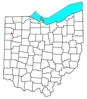
Van Wert County is a county located in the U.S. state of Ohio. As of the 2020 census, the population was 28,931. Its county seat is Van Wert. The county was created in 1820 and later organized in 1837. It is named for Isaac Van Wart, one of the captors of John André in the American Revolutionary War.

Van Wert is a city in northern Decatur County, Iowa, United States. The population was 178 at the time of the 2020 census.

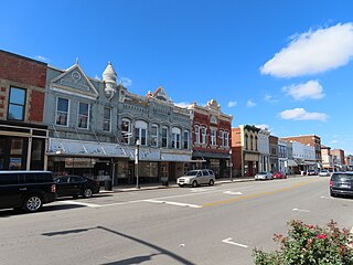
Van Wert is a city in and the county seat of Van Wert County, Ohio, United States. The municipality is located in northwestern Ohio approximately 77 mi (123 km) SW of Toledo and 34 mi (54 km) SE of Fort Wayne, Indiana. The population was 10,846 at the 2010 census. It is the principal city of and is included in the Van Wert Micropolitan Statistical Area, which is included in the Lima-Van Wert-Wapakoneta, Ohio Combined Statistical Area. Van Wert is named for Isaac Van Wart, one of the captors of Major John André in the American Revolutionary War. A center of peony cultivation, Van Wert has hosted the annual Van Wert Peony Festival on and off since 1902. Van Wert is home to the first county library in the United States, the Brumback Library. It also has a thriving community art center the Wassenburg Art Center and the award-winning Van Wert Civic Theatre. The home office of Central Insurance Companies is located in Van Wert.
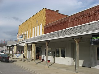
Willshire is a village in Van Wert County, Ohio, United States. The population was 397 at the 2010 census. It is included within the Van Wert, Ohio Micropolitan Statistical Area.
Delphos is a city in Allen and Van Wert counties in the U.S. state of Ohio approximately 14 mi (23 km) northwest of Lima and 13 mi (21 km) east of Van Wert. The population was 7,101 at the 2010 census.

The Big Sandy River is a tributary of the Ohio River, approximately 29 miles (47 km) long, in western West Virginia and northeastern Kentucky in the United States. The river forms part of the boundary between the two states along its entire course. Via the Ohio River, it is part of the Mississippi River watershed.
Flatrock Creek is a 57.2-mile-long (92.1 km) tributary of the Auglaize River in northeastern Indiana and northwestern Ohio in the United States. It drains a primarily rural farming area in the watershed of Lake Erie.

Marion Township is one of the twelve townships of Allen County, Ohio, United States. As of the 2010 census, the population was 6,715.
Roselms is an unincorporated community in southwestern Washington Township, Paulding County, Ohio, United States, in the northwestern part of the state. It lies along State Route 114 midway between Grover Hill and Mandale, about 3 miles (5 km) from each. Its elevation is 718 feet (219 m).

Glenmore is an unincorporated community in eastern Willshire Township, Van Wert County, Ohio, United States. It lies at the intersection of the north-south Glenmore Road with the east-west Glenmore Road. Twentyseven Mile Creek, a subsidiary of the St. Marys River, runs on the western edge of Glenmore after rising a short distance to the south of the community. It is located 8½ miles southwest of Van Wert, the county seat of Van Wert County.

Dull is an unincorporated community in Liberty Township, Van Wert County, Ohio, United States. Dull is 2.50 miles (4.02 km) west-southwest of Ohio City.
Van Wert is an unincorporated community in Polk County, in the U.S. state of Georgia.
Cavett is an unincorporated community in Van Wert County, in the U.S. state of Ohio.
Dixon is an unincorporated community in Allen County, Indiana and Van Wert County, Ohio.
Hoaglin is an unincorporated community in Van Wert County, in the U.S. state of Ohio.
Jonestown is an unincorporated community in Van Wert County, in the U.S. state of Ohio.
Middlebury is an unincorporated community in Van Wert County, in the U.S. state of Ohio.
Monticello is an unincorporated community in Van Wert County, in the U.S. state of Ohio.
Schumm is an unincorporated community in Van Wert County, in the U.S. state of Ohio.
Seamersville is an unincorporated community within the Township of Jackson, a division of Van Wert County, in the U.S. state of Ohio.

