Related Research Articles
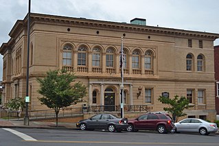
Floyd County is a county located in the northwestern part of the U.S. state of Georgia. As of the 2020 United States Census, the population was 98,584. The county seat is Rome.

The Etowah River is a 164-mile-long (264 km) waterway that rises northwest of Dahlonega, Georgia, north of Atlanta. On Matthew Carey's 1795 map the river was labeled "High Town River". On later maps, such as the 1839 Cass County map, it was referred to as "Hightower River", a name that was used in most early Cherokee records.

Livingston is an unincorporated community in Floyd County, in the U.S. state of Georgia.

Mount Berry is an unincorporated community contiguous with the main campus of Berry College in Floyd County, Georgia, United States, bordering the city of Rome. Mount Berry Mall, the shopping mall serving Rome, is in the Mount Berry area. It is part of the Rome, Georgia Metropolitan Statistical Area. The ZIP Code for Mount Berry is 30149.
Georgia Northwestern Technical College (GNTC) is a public technical college serving nine counties across northwestern Georgia. It operates under the Technical College System of Georgia. The college has six campuses: Catoosa County campus, Walker County Campus, Floyd County Campus, Gordon County Campus, Polk County Campus, and Whitfield-Murray Campus.
Anniedelle is an unincorporated community in Floyd County, in the U.S. state of Georgia.
Boozeville is an unincorporated community in Floyd County, in the U.S. state of Georgia.
Chulio is an unincorporated community in Floyd County, in the U.S. state of Georgia.

Everett Springs is an unincorporated community in Floyd County, in the U.S. state of Georgia.
Foster Mills is an unincorporated community in Floyd County, in the U.S. state of Georgia.

Horseleg Mountain is a summit in Floyd County, Georgia, in the United States. With an elevation of 1,322 feet (403 m), Horseleg Mountain is the 735th highest summit in the state of Georgia.

Johns Mountain is a summit in the U.S. state of Georgia. With an elevation of 1,683 feet (513 m), Johns Mountain is the 666th highest summit in the state of Georgia. The mountain is located inside the Chattahoochee-Oconee National Forest.
Lavender is an unincorporated community in Floyd County, in the U.S. state of Georgia.

Six Mile is an unincorporated community in Floyd County, in the U.S. state of Georgia.

Turkey Mountain is a summit in Floyd County, Georgia. With an elevation of 1,122 feet (342 m), Turkey Mountain is the 808th highest summit in the state of Georgia.
Vans Valley is an unincorporated community in Floyd County, in the U.S. state of Georgia.
Maxville is an unincorporated community in White River Township, Randolph County, in the U.S. state of Indiana.
Cunningham is an unincorporated community in Floyd County, in the U.S. state of Georgia.
References
- ↑ U.S. Geological Survey Geographic Names Information System: Glenwood, Floyd County, Georgia
- ↑ "Floyd County". Calhoun Times. September 1, 2004. p. 68. Retrieved April 24, 2015.
Municipalities and communities of Floyd County, Georgia, United States | ||
|---|---|---|
| Cities | 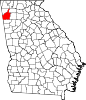 | |
| CDPs | ||
| Unincorporated communities | ||
34°18′44″N85°10′20″W / 34.31222°N 85.17222°W
| | This Floyd County, Georgia state location article is a stub. You can help Wikipedia by expanding it. |