Related Research Articles
Floyd County is a county located in the northwestern part of the U.S. state of Georgia. As of the 2020 United States Census, the population was 98,584. The county seat is Rome.

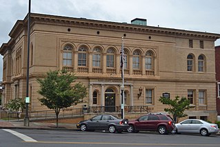
Cave Spring is a city in Floyd County, Georgia, United States. It is located 17 miles (27 km) southwest of Rome, the county seat. The population of Cave Spring was 1,200 at the 2010 census, up from 975 at the 2000 census. It is part of the Rome, Georgia Metropolitan Statistical Area.

Lindale is an unincorporated community and census-designated place (CDP) in Floyd County, Georgia, United States. It is part of the Rome, Georgia Metropolitan Statistical Area. The population was 4,191 at the 2010 census.

Livingston is an unincorporated community in Floyd County, in the U.S. state of Georgia.
Anniedelle is an unincorporated community in Floyd County, in the U.S. state of Georgia.
Boozeville is an unincorporated community in Floyd County, in the U.S. state of Georgia.
Chulio is an unincorporated community in Floyd County, in the U.S. state of Georgia.

Everett Springs is an unincorporated community in Floyd County, in the U.S. state of Georgia.
Foster Mills is an unincorporated community in Floyd County, in the U.S. state of Georgia.
Glenwood is an unincorporated community in Floyd County, in the U.S. state of Georgia.

Horseleg Mountain is a summit in Floyd County, Georgia, in the United States. With an elevation of 1,322 feet (403 m), Horseleg Mountain is the 735th highest summit in the state of Georgia.

Johns Mountain is a summit in the U.S. state of Georgia. With an elevation of 1,683 feet (513 m), Johns Mountain is the 666th highest summit in the state of Georgia. The mountain is located inside the Chattahoochee-Oconee National Forest.


Silver Creek is a stream in Floyd County and Polk County, Georgia, in the United States.
Six Mile is an unincorporated community in Floyd County, in the U.S. state of Georgia.

Turkey Mountain is a summit in Floyd County, Georgia. With an elevation of 1,122 feet (342 m), Turkey Mountain is the 808th highest summit in the state of Georgia.
Vans Valley is an unincorporated community in Floyd County, in the U.S. state of Georgia.
Estelle is an unincorporated community in Walker County, in the U.S. state of Georgia.
Cunningham is an unincorporated community in Floyd County, in the U.S. state of Georgia.
References
- ↑ U.S. Geological Survey Geographic Names Information System: Lavender, Georgia
- ↑ "Floyd County". Jim Forte Postal History. Retrieved April 25, 2015.
- ↑ "Floyd County". Calhoun Times. September 1, 2004. p. 70. Retrieved April 24, 2015.
Municipalities and communities of Floyd County, Georgia, United States | ||
|---|---|---|
| Cities | 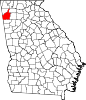 | |
| CDPs | ||
| Unincorporated communities | ||
34°17′31″N85°20′28″W / 34.29194°N 85.34111°W
| | This Floyd County, Georgia state location article is a stub. You can help Wikipedia by expanding it. |