Related Research Articles

Mammoth Cave National Park is an American national park in west-central Kentucky, encompassing portions of Mammoth Cave, the longest cave system known in the world.

Goochland County is a county located in the Piedmont of the Commonwealth of Virginia. Its southern border is formed by the James River. As of the 2020 census, the population was 24,727. Its county seat is Goochland.

The Chinhoyi Caves are a group of limestone and dolomite caves in north central Zimbabwe. Designated a National Park in 1955, and managed by the Zimbabwe Parks & Wildlife Management Authority.

The James River and Kanawha Canal was a partially built canal in Virginia intended to facilitate shipments of passengers and freight by water between the western counties of Virginia and the coast. Ultimately its towpath became the roadbed for a rail line following the same course.

Mount Ida, known variously as Idha, Ídhi, Idi, and Ita, is the highest mountain on the island of Crete, with an elevation of 2,456 metres (8,058 ft). It has the highest topographic prominence of any mountain in Greece. A natural park which includes Mount Ida is a member of UNESCO's Global Geoparks Network.

State Route 6 is a primary state highway in the U.S. state of Virginia. Known for most of its length as River Road, the state highway runs 102.26 miles (164.57 km) from U.S. Route 250 in Afton east to SR 161 in Richmond. SR 6 is one of the main highways of mountainous Nelson County, where the highway runs north–south from its beginning to US 29. From Scottsville to Richmond, the state highway parallels the James River. SR 6 is a major suburban highway through southwestern Henrico County and the main street of Richmond's West End.

State Route 288 is a primary state highway in the U.S. state of Virginia. It is a freeway-standard partial beltway around the southwest side of the Richmond, Virginia metropolitan area in portions of Goochland, Powhatan, and Chesterfield counties. SR 288 was officially dedicated as the World War II Veterans Memorial Highway in 2004.
Goochland is a census-designated place (CDP) in and the county seat of Goochland County, Virginia, United States. The population as of the 2010 census was 861. The community is also known as Goochland Courthouse or by an alternative spelling, Goochland Court House. It derives its name from the fact that the community is the location of the county's court house, while the county in turn is named for Sir William Gooch, 1st Baronet, the royal lieutenant governor of Virginia from 1727 to 1749.

State Route 45 is a primary state highway in the U.S. state of Virginia. The state highway runs 39.72 miles (63.92 km) from the junction of U.S. Route 15 Business and US 460 Business in Farmville north to SR 6 at Georges Tavern. SR 45 is the primary north–south highway of Cumberland County, where the highway meets US 60 near the county seat, Cumberland.

State Route 271 is a primary state highway in the U.S. state of Virginia. Known as Pouncey Tract Road, the state highway runs 7.34 miles (11.81 km) from U.S. Route 250 in Short Pump north to SR 620 and SR 622 in Rockville. A small section of it was first added to the state highway system during 1930, and it gained its current routing and designation by 1940.

The Belum Caves, located in Nandyala district of Andhra Pradesh's Rayalaseema region, is the second largest cave system on the Indian subcontinent, known for its speleothems, such as stalactite and stalagmite formations. The Belum Caves have long passages, galleries, spacious caverns with fresh water and siphons. This cave system was formed over the course of tens of thousands of years by the constant flow of underground water from the now-disappeared river Chitravathi. The cave system reaches its deepest point at the point known as Pataalaganga. Belum Caves have a length of 3,229 m (10,593.8 ft), making them the second largest caves on the Indian Subcontinent after the Krem Liat Prah caves in Meghalaya. It is one of the centrally protected Monuments of National Importance.

The Mahameghavahana dynasty was an ancient ruling dynasty of Kalinga after the decline of the Maurya Empire. In the first century B.C., Mahameghavahana, a king of Chedirastra conquered Kalinga and Kosala. During the reign of Kharavela, the third king of Mahameghavahana dynasty, South Kosala became an integral part of the kingdom. He patronised Jainism, but did not discriminate against other religions. He is known by his Hathigumpha inscription.
Oilville is an unincorporated community in Goochland County, Virginia, United States. Oilville is located on U.S. Route 250 22 miles (35 km) west-northwest of Richmond. Oilville has a post office with ZIP code 23129.
Goochland may refer to:

This is a list of the National Register of Historic Places listings in Goochland County, Virginia.

Clover Forest, located in Goochland, Virginia between Richmond and Charlottesville, is an authentically restored Federal home on the upper James River, in the Piedmont. It has a Federal-style mansion, with portions dating to pre-Revolutionary America; terraced landscaped grounds, and a private lake. The property lies in a large bend of the James River.

Crozier is an unincorporated community in Goochland County, Virginia, United States. Crozier is located on Virginia State Route 6, about 5.8 miles (9.3 km) east-southeast of Goochland. Crozier has a post office with ZIP code 23039.
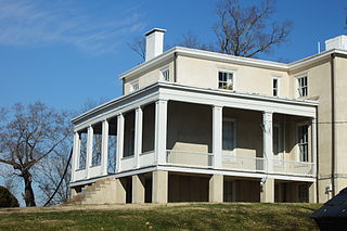
Elk Hill, also known as Harrison's Elk Hill, is a historic plantation home located near Goochland, Goochland County, Virginia. It was built between 1835 and 1839, and is a 2+1⁄2-story, three-bay, stuccoed brick central-hall-plan house in the Greek Revival style. It has a two-story rear ell. The front facade features a one-story Tuscan order portico consisting of paired rectangular wooden pillars supporting a full entablature. Also on the property are the contributing servants' quarters, tack house, and spring house. It was listed on the National Register of Historic Places in 1979.
Virginia's 56th House of Delegates district elects one of 100 seats in the Virginia House of Delegates, the lower house of the state's bicameral legislature. District 56 includes Louisa County, as well as portions of Goochland, Henrico, and Spotsylvania counties. It has been represented by Republican John McGuire III since 2018.
References
- ↑ Atlas - Great Caves Of The World, ISBN 0-939748-21-5
- ↑ SWORCA Digest 1975, Library of Congress Catalog GB601.A1 S6616