Gooderham Building

Last updated

Gooderham Building
Gooderham Building, Toronto, East view 20170417 1.jpg
The Gooderham Building in 2017
Gooderham Building
Alternative namesFlatiron Building
General information
Type Office building
Architectural style Romanesque Revival
Location49 Wellington Street East
Toronto, Ontario
M5E 1C9
Completed1892
OwnerLee Chow Group
Height16.70 metres (54.8 ft)
Technical details
Floor count5
Design and construction
Architect(s)David Roberts Jr.
Designated1975

The Gooderham Building, also known as the Flatiron Building, is an historic office building at 49 Wellington Street East in Toronto, Ontario, Canada. It is located on the eastern edge of the city's Financial District (east of Yonge Street) in the St. Lawrence neighbourhood, wedged between Front Street and Wellington Street in Downtown Toronto, where they join up to form a triangular intersection. Completed in 1892, the red-brick edifice was an early example of a prominent flatiron building.

Contents

The Gooderham Building is the focal point of one of Toronto's most iconic vistas: looking west down Front Street towards the building's prominent rounded corner, framed on the sides by the heritage commercial blocks along Front Street, and with the skyscrapers of the Financial District towering in the background. The CN Tower is also visible from certain angles behind Brookfield Place. This vista frequently appears in imagery of the city.

History

The Gooderham Building, c. 1895. GooderhamBuilding1890s.jpg
The Gooderham Building, c. 1895.

The previous building on the site was shorter, but in the same shape, and it was called the Coffin Block. The current building was designed by architect David Roberts Jr. and originally cost $18,000 to construct for distiller George Gooderham Sr. (1830–1905), [1] a son of the Gooderham and Worts distillery's founder, William Gooderham. The building served as the office of the Gooderham and Worts distillery until 1952, and it was sold by the Gooderham family in 1957.

Bought in 1975 and saved (and partially restored) by David Walsh and Robert Phillips, further restoration took place in 1998 by owners Michael and Anne Tippin. The building was designated a historic site under the Ontario Heritage Act in 1975, then the Ontario Heritage Foundation attained a Heritage Easement in 1977. [2] It was subsequently owned and managed by the Woodcliffe Corporation.

On 12 October 2011, the Woodcliffe Corporation announced that it would be selling the building. Previously, the building had sold for $10.1 million in 2005, and for $2.2 million in 1999. [3] The building is currently owned and managed by Lee Chow Group.

Architecture and art

The Gooderham Building is well-known both for its narrow wedge shape and for the mural on its back wall. The Flatiron Mural by renowned Canadian artist Derek Michael Besant uses a trompe-l'œil effect to not only make the wall appear to have more windows than it does, but to also give it a more mobile effect by having its edges 'fluttering' away where they are not 'tacked' down. It is a picture of the Perkins Building, which is located directly across the street.

The building has a Romanesque cornice and frieze above the arched windows on the 4th floor. The main entrance located on Wellington Street makes use of a French Gothic archway. The foundation is made of sandstone. The steep copper roof has eight gable dormers: four on the south facade and four on the north facade.

With its linear pattern of fenestration distributed equally on all floors, it conveys a light feeling of a corporate office building. The Gooderham Building is set on a high foundation that reaches half a storey above the ground. These days, it is still being used as an office building. The 1st floor uses rectangular sliding windows on the south side, but it has fixed windows on the north side. Conversely, on the 2nd floor, it uses fixed windows on the south side and rectangular sliders on the north side. On the 3rd, 4th and 5th floors, the Gooderham Building has single-hung and arch-hung windows.

The Gooderham Building has three entrances. Two of the entrances lead to the pub in the basement known as The Flatiron and Firkin. Entrance doors are in pairs, and have wooden frames for windows. The pub in the basement has a large patio around the south side of the building. Entrances for the pub are located in the basement and the 1st floor on the Front Street side. There is no public access to the pub from the building. The entrance for the Flatiron Building is located on the north side, and is made up of fanciful pinnacle dormers and arch frames with French Gothic styling.

Berczy Park

Berczy Park is a small park situated behind the Gooderham Building. Gooderham Building backside 2023.jpg
Berczy Park is a small park situated behind the Gooderham Building.

Berczy Park is a small park located behind the Gooderham Building at Front Street and Wellington Street in Toronto. The site was home to several buildings with the most notable being the Clarendon Hotel around the mid 19th Century. By the late 19th century and early 20th century, commercial buildings ranging from offices, wholesalers, jewellers and lithographers occupied the area: [4]

Once these buildings were demolished the site became a vacant lot and then as parking lot in the mid 1960s and informal grass lot by 1975, but did not become a city park with a few benches and walled sections in 1980. The current tree-lined city park was added and renovations, completed in 2017, added a large three-tier fountain designed by Montreal landscape architect Claude Cormier. The fountain features 27 cast-iron dogs spouting water, a cast-iron cat looking at two bird sculptures on a nearby wire, and a bone crowning the fountain. [5] The fountain, which features a trough for dogs to drink from, became a popular destination, particularly for dog lovers. [6]

See also

Related Research Articles

<span class="mw-page-title-main">William Berczy</span> Canadian pioneer and painter (1744–1813)

William von Moll Berczy was a German-born Upper Canada pioneer and painter. He is considered one of the co-founders of the Town of York, Upper Canada, now Toronto, Ontario, Canada.

<span class="mw-page-title-main">St. Lawrence, Toronto</span> Neighbourhood in Canada, Ontario, Toronto

St. Lawrence is a neighbourhood located in downtown Toronto, Ontario, Canada. The area, a former industrial area, is bounded by Yonge, Front, and Parliament Streets, and the Canadian National railway embankment. The Esplanade off Yonge St., lined with restaurants, cafés and hotels runs through the middle of the area. In previous times, the area was sometimes referred to as 'St. Lawrence Ward' or more often today as 'St. Lawrence Market', synonymous with the large retail vendor market which is the neighbourhood's focal point. The area is the site of a large city-sponsored housing project of the 1970s, which revitalized an old brownfields area. The boundaries of the St Lawrence Neighbourhood Association and the St Lawrence Market BIA are somewhat larger than those noted above. Both groups have boundaries that extend from Yonge to Parliament Streets and Queen Street East to the rail corridor.

<span class="mw-page-title-main">Exhibition Place</span> Publicly owned mixed-use development in Toronto

Exhibition Place is a publicly owned mixed-use district in Toronto, Ontario, Canada, located by the shoreline of Lake Ontario, just west of downtown. The 197-acre (80 ha) site includes exhibit, trade, and banquet centres, theatre and music buildings, monuments, parkland, sports facilities, and a number of civic, provincial, and national historic sites. The district's facilities are used year-round for exhibitions, trade shows, public and private functions, and sporting events.

<span class="mw-page-title-main">Toronto Harbour</span> Bay on the north shore of Lake Ontario, in Toronto, Ontario, Canada

Toronto Harbour or Toronto Bay is a natural bay on the north shore of Lake Ontario, in Toronto, Ontario, Canada. Today, the harbour is used primarily for recreational boating, including personal vessels and pleasure boats providing scenic or party cruises. Ferries travel from docks on the mainland to the Islands, and cargo ships deliver aggregates and raw sugar to industries located in the harbour. Historically, the harbour has been used for military vessels, passenger traffic and cargo traffic. Waterfront uses include residential, recreational, cultural, commercial and industrial sites.

<span class="mw-page-title-main">Metropolitan Life North Building</span> Office skyscraper in Manhattan, New York

The Metropolitan Life North Building, now known as Eleven Madison, is a 30-story Art Deco skyscraper adjacent to Madison Square Park at 11-25 Madison Avenue in the Flatiron District neighborhood of Manhattan in New York City. The building is bordered by East 24th Street, Madison Avenue, East 25th Street and Park Avenue South, and was formerly connected by a sky bridge and tunnel to the Metropolitan Life Insurance Company Tower just south of it.

<span class="mw-page-title-main">Front Street (Toronto)</span> Thoroughfare in Toronto, Ontario

Front Street is an east–west road in downtown Toronto, Ontario, Canada. First laid out in 1796, the street is one of the original streets of the Town of York. The street was laid out along the shoreline of Lake Ontario as it existed during that time. It remains an important street, with many important uses located along it, including the St. Lawrence Market, Meridian Hall, Union Station and the Metro Toronto Convention Centre. The eastern section of Front Street, in the West Don Lands, east of Cherry Street, is being rebuilt as a broad tree-lined boulevard, intended to be the pedestrian-friendly commercial spine of the new neighbourhood.

<span class="mw-page-title-main">St. Lawrence Market South</span> Public market in Toronto, Canada

The St. Lawrence Market South building is a major public market building in Toronto, Ontario, Canada. It is located on the southwest corner of Front and Lower Jarvis Streets. Along with the St. Lawrence Market North and St. Lawrence Hall, it comprises the St. Lawrence Market complex. The current building was opened in 1902, incorporating the 1845 Toronto City Hall building into the structure. The building was restored during the 1970s.

<span class="mw-page-title-main">Distillery District</span> Neighbourhood in Toronto, Ontario, Canada

The Distillery District is a commercial and residential district in Toronto, Ontario, Canada, east of downtown, which contains numerous cafés, restaurants, and shops housed within heritage buildings of the former Gooderham and Worts Distillery. The 13 acres (5.3 ha) district comprises more than forty heritage buildings and ten streets, and is the largest collection of Victorian-era industrial architecture in North America.

<span class="mw-page-title-main">College Park (Toronto)</span> Complex in Toronto, Ontario, Canada

College Park is a shopping mall, residential and office complex on the southwest corner of Yonge and College streets in Toronto, Ontario, Canada.

<span class="mw-page-title-main">Ontario Legislative Building</span> Legislative building in Toronto, Canada

The Ontario Legislative Building is a structure in central Toronto, Ontario, Canada. It houses the Legislative Assembly of Ontario, and the viceregal suite of the Lieutenant Governor of Ontario and offices for members of the provincial parliament (MPPs). The building is surrounded by Queen's Park, sitting on that part south of Wellesley Street, which is the former site of King's College, which was leased from the university by the municipal government of Toronto in 1859, for a "peppercorn" payment of CAD$1 per annum on a 999-year term. The southern portion of the site was later handed over to the provincial government.

<span class="mw-page-title-main">Toronto Coach Terminal</span> Decommissioned bus terminal

The Toronto Coach Terminal is a decommissioned bus station for intercity bus services in Toronto, Ontario, Canada. The building was the central intercity bus station in Toronto until mid-2021, when it was replaced by the Union Station Bus Terminal. It is located at 610 Bay Street, in the city's downtown. Opened in 1931 as the Gray Coach Terminal, the Art Deco style structure was the main hub for Gray Coach, an interurban coach service then owned by the Toronto Transportation Commission (TTC). It replaced an earlier open air depot, the Union Coach Terminal.

<span class="mw-page-title-main">North Toronto station</span> Former railway station in Toronto

The North Toronto railway station is a former Canadian Pacific Railway (CPR) station in the northwest corner of the Rosedale neighbourhood of Toronto, Ontario, Canada. It is located on the east side of Yonge Street, adjacent to the neighbourhood of Summerhill, and a short distance south of the Summerhill subway station. The building is now home to a Liquor Control Board of Ontario (LCBO) liquor store.

<span class="mw-page-title-main">Coffin Block Building</span> Building in Toronto, Ontario, Canada

The Coffin Block Building at Front and Church streets was the first flatiron building in Toronto, Ontario, Canada.

<span class="mw-page-title-main">Cass Park Historic District</span> Historic district in Michigan, United States

The Cass Park Historic District is a historic district in Midtown Detroit, Michigan, consisting of 25 buildings along the streets of Temple, Ledyard, and 2nd, surrounding Cass Park. It was listed on the National Register of Historic Places in 2005 and designated a city of Detroit historic district in 2016.

<span class="mw-page-title-main">Queensland Government Printing Office</span> Historic site in Queensland, Australia

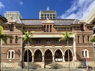
The Queensland Government Printing Office is a heritage-listed printing house at 110 George Street and 84 William Street, Brisbane City, Queensland, Australia. It was designed by John James Clark, Francis Drummond Greville Stanley, and Edwin Evan Smith and built from 1884 to 1887 by John Petrie and Thomas Hiron. It is also known as The Printing Building, Sciencentre, Public Services Club, and Registry of Births, Deaths & Marriages. It was added to the Queensland Heritage Register on 21 October 1992.

<span class="mw-page-title-main">Christian Dick Block</span> United States historic place

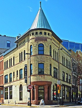
The Christian Dick Block is a historic commercial building located at 106 East Doty Street in Madison, Wisconsin. The building was constructed in 1889 for liquor wholesaler Christian Dick. The prominent Madison architectural firm of Conover & Porter designed the Richardsonian Romanesque style building; it is one of the city's earliest extant examples of both the firm's work and the style. The building was added to the National Register of Historic Places in 2002.

<span class="mw-page-title-main">Stratford City Hall</span> City hall in Ontario, Canada

Stratford City Hall is the city hall of Stratford, Ontario, and a National Historic Site of Canada. It sits amidst the city's business district, on a triangular town square.

<span class="mw-page-title-main">Berczy Park</span> Park in Toronto, Ontario, Canada

Berczy Park is a small park in downtown Toronto, Ontario, Canada. The park is triangular in shape, bounded by Scott Street, Front Street and Wellington Street. The park is bordered at its eastern tip, where Wellington and Front join, by the Gooderham Building, a heritage building that is an example of a "flatiron building". A widely admired mural graces the western facade of the building.

<span class="mw-page-title-main">Tinlinn Apartments</span> United States historic place

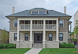
The Tinlinn Apartments is an apartment building located at 413 Garland Street in Flint, Michigan. The building was listed on the National Register of Historic Places in 2008.

<span class="mw-page-title-main">Clydebank, Millers Point</span> Historic site in New South Wales, Australia

Clydebank is a heritage-listed residence at 43 Lower Fort Street, in the inner city Sydney suburb of Millers Point in the City of Sydney local government area of New South Wales, Australia. It was built from 1824 to 1825 by Robert Crawford. It is also known as Bligh House, Holbeck and St Elmo. It has also served as an art gallery and as offices in the past. It was added to the New South Wales State Heritage Register on 2 April 1999.

References

  1. Dean Beeby, “GOODERHAM, GEORGE,” in Dictionary of Canadian Biography, vol. 13, University of Toronto/Université Laval, 2003–, accessed October 11, 2015.
  2. "Ontario Heritage Trust - Gooderham Building (City of Toronto) - 1891-92". Archived from the original on September 30, 2010. Retrieved October 18, 2010.
  3. "Toronto's iconic Flatiron Building up for sale - The Globe and Mail". The Globe and Mail . Archived from the original on October 13, 2011.
  4. https://maps.library.utoronto.ca/datapub/digital/NG/goad/1884/04atlas-r-38.jpg
  5. Hume, Christopher (May 23, 2017). "Berczy Park redesign displays St. Lawrence neighbourhood's creative thinking: Hume". The Toronto Star.
  6. "The Best Dog Parks in Toronto".

43°38′54″N79°22′27″W / 43.648366°N 79.374284°W / 43.648366; -79.374284