Grand Forks Air Force Base (CDP)

Last updated
Grand Forks AFB, North Dakota
Grand Forks AFB ND - 17 Sep 1997.jpg
The base in 1997
Coordinates: 47°57′18″N97°23′12″W / 47.95500°N 97.38667°W / 47.95500; -97.38667 Coordinates: 47°57′18″N97°23′12″W / 47.95500°N 97.38667°W / 47.95500; -97.38667
CountryUnited States
State North Dakota
County Grand Forks
Area
[1]
  Total7.50 sq mi (19.42 km2)
  Land7.50 sq mi (19.42 km2)
  Water0.00 sq mi (0.00 km2)
Elevation
895 ft (273 m)
Population
 (2020)
  Total2,002
  Density266.93/sq mi (103.07/km2)
Time zone UTC-6 (Central (CST))
  Summer (DST) UTC-5 (EDT)
Area code 701
FIPS code 38-32140
GNIS feature ID2393020
Website grandforks.af.mil

Grand Forks Air Force Base is a census-designated place (CDP) in Grand Forks County, North Dakota, United States. It corresponds to Grand Forks Air Force Base, a United States Air Force installation. As of the 2020 census, the CDP had a population of 2,002. [2]

Contents

Demographics

Historical population
CensusPop.
1970 10,474
1980 9,390−10.3%
1990 9,343−0.5%
2000 4,832−48.3%
2010 2,367−51.0%
2020 2,002−15.4%
source: [3]

2020 Census

It is part of the "Grand Forks, ND-MN Metropolitan Statistical Area" or "Greater Grand Forks". According to the United States Census Bureau, the CDP has a total area of 8.1 square miles (21 km2), all land. [4]

As of the census [5] of 2000, there were 4,832 people, 1,279 households, and 1,230 families residing on the base. The population density was 590.5 people per square mile (228.1/km2). There were 1,516 housing units at an average density of 185.2/sq mi (71.6/km2). The racial makeup of the base was 80.9% White, 8.4% Black or African American, 0.9% Native American, 2.4% Asian, 0.3% Pacific Islander, 2.7% from other races, and 4.5% from two or more races. Hispanic or Latino of any race were 6.0% of the population.

There were 1,279 households, out of which 77.3% had children under the age of 18 living with them, 88.5% were married couples living together, 4.1% had a female householder with no husband present, and 3.8% were non-families. 3.0% of all households were made up of individuals, and none had someone living alone who was 65 years of age or older. The average household size was 3.41 and the average family size was 3.48.

On the base the population was spread out, with 38.4% under the age of 18, 20.4% from 18 to 24, 39.4% from 25 to 44, 1.7% from 45 to 64, and 0.1% who were 65 years of age or older. The median age Was 22 years. For every 100 females, there were 115.0 males. For every 100 females age 18 and over, there were 123.9 males.

The median income for a household on the base was $36,414, and the median income for a family was $36,104. Males had a median income of $24,413 versus $17,750 for females. The per capita income for the base was $11,503. About 4.0% of families and 4.2% of the population were below the poverty line, including 3.6% of those under the age of 18 and none of those 65 and older.

Related Research Articles

<span class="mw-page-title-main">East Fork, Arizona</span> CDP in Navajo County, Arizona

East Fork is a census-designated place (CDP) in Navajo County, Arizona, United States, on the Fort Apache Indian Reservation. The population was 699 at the 2010 census.

<span class="mw-page-title-main">McRoberts, Kentucky</span> Census-designated place in Kentucky, United States

McRoberts is an unincorporated community and census-designated place (CDP) in Letcher County, Kentucky, United States. The population was 784 at the 2010 United States Census, down from 921 at the 2000 census. McRoberts is in the Eastern Kentucky Coalfield region.

<span class="mw-page-title-main">Spring Creek, Nevada</span> CDP in Nevada, United States

Spring Creek is a census-designated place (CDP) in central Elko County, in northeastern Nevada in the western United States. It mainly serves as a bedroom community for the businesses and industries in and around the nearby city of Elko. It is part of the Elko Micropolitan Statistical Area. The population was 12,361 at the 2010 census.

<span class="mw-page-title-main">Parc, New York</span> Census-designated place in New York, United States

Parc is a location and census-designated place in Clinton County, New York, United States. The name "Parc" is derived from the official name for the 3,447-acre (13.95 km2) industrial site, which is PARC, an acronym for the Plattsburgh Airbase Redevelopment Corporation. PARC was established for the purpose of redeveloping the Plattsburgh Air Force Base after it closed on September 25, 1995. PARC is now operated by the Plattsburgh Air Base Development Authority, and the massive airfield is now Plattsburgh International Airport. The population of the Parc CDP was 254 at the 2010 census. Parc is located in the town of Plattsburgh and is bordered to the north by the city of Plattsburgh.

<span class="mw-page-title-main">North Sea, New York</span> Hamlet and census-designated place in New York, United States

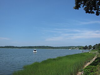
North Sea is a hamlet and census-designated place (CDP) in the Town of Southampton in Suffolk County, on the South Fork of Long Island, in New York, United States. The population was 4,458 at the 2010 census.

<span class="mw-page-title-main">Emerado, North Dakota</span> City in North Dakota, United States

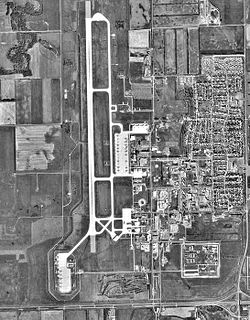
Emerado is a city in Grand Forks County, North Dakota, United States located near Grand Forks Air Force Base. It is part of the "Grand Forks, ND-MN Metropolitan Statistical Area" or "Greater Grand Forks". The population was 443 at the 2020 census. Grand Forks Air Force Base is located near Emerado.

<span class="mw-page-title-main">North Fork Village, Ohio</span> Former CDP in Ohio, United States

North Fork Village is an unincorporated community and former census-designated place (CDP) in Ross County, Ohio, United States. The population was 1,726 at the 2000 census. It was not delineated as a CDP for the 2010 census.

<span class="mw-page-title-main">Hebo, Oregon</span> Unincorporated community in the state of Oregon, United States

Hebo is an unincorporated community in Tillamook County, Oregon, United States. For statistical purposes, the United States Census Bureau has defined Hebo as a census-designated place (CDP). The census definition of the area may not precisely correspond to local understanding of the area with the same name. The population of the CDP was 231 at the 2000 census.

<span class="mw-page-title-main">Claysburg, Pennsylvania</span> Census-designated place in Pennsylvania, United States

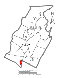
Claysburg is a census-designated place (CDP) along Interstate 99 and the Allegheny Front near the base of Blue Knob (Pennsylvania). As of 2010 census, it had a population of 1,625.

<span class="mw-page-title-main">Palmyra, Utah</span> CDP in Utah, United States

Palmyra is a census-designated place (CDP) in Utah County, Utah, United States. It is part of the Provo–Orem Metropolitan Statistical Area. The population was 491 at the 2010 census. Palmyra is located directly west of Springville and northwest of Spanish Fork.

<span class="mw-page-title-main">Moses Lake North, Washington</span> Census-designated place in Washington, United States

Moses Lake North is a census-designated place (CDP) in Grant County, Washington, United States. The population was 4,050 at the 2020 census.

<span class="mw-page-title-main">Riverbend, Washington</span> Census-designated place in Washington, United States

Riverbend is an unincorporated community and census-designated place (CDP) in King County, Washington, United States. The population was 2,132 at the 2010 census.

<span class="mw-page-title-main">Lake Stickney, Washington</span> CDP in Washington, United States

Lake Stickney is a census-designated place (CDP) in Snohomish County, Washington, United States. The population was 7,777 at the 2010 census. The CDP was known as Paine Field-Lake Stickney prior to 2010. The new Lake Stickney CDP no longer contains the Paine Field airport.

<span class="mw-page-title-main">Coal Fork, West Virginia</span> Census-designated place in West Virginia, United States

Coal Fork is an unincorporated census-designated place (CDP) in Kanawha County, West Virginia, United States. It is part of a larger unincorporated community known as Campbells Creek, approximately 10 minutes east of Charleston. The population was 1,233 at the 2010 census.

<span class="mw-page-title-main">Hickam Housing, Hawaii</span> Census-designated place in Hawaii, United States

Hickam Housing is a census-designated place comprising part of Joint Base Pearl Harbor–Hickam in the City & County of Honolulu, Hawaii, United States. The population was 7,581 at the 2020 census. The CDP occupies the area that was formerly Hickam Air Force Base.

<span class="mw-page-title-main">Enterprise, West Virginia</span> Census-designated place in West Virginia, United States

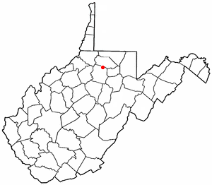
Enterprise is a census-designated place (CDP) in Harrison County, West Virginia, United States, along the West Fork River. The population was 961 at the 2010 census.

<span class="mw-page-title-main">Loring Air Force Base (CDP)</span> Former census-designated place in Maine, United States

Loring Air Force Base is a former census-designated place (CDP) in the town of Limestone in Aroostook County, Maine, United States. It was the site of Loring Air Force Base, at one time the largest base for the U.S. Air Force's Strategic Air Command. The population of the CDP was 225 at the 2000 census. It was not counted during the 2010 census.

Andrews Air Force Base is a census-designated place (CDP) covering the residential population of Andrews Air Force Base/Joint Base Andrews, in Prince George's County, Maryland, Maryland, United States. The population at the 2020 Census was 3,025.

Lackland Air Force Base CDP is a census-designated place (CDP) covering the permanent residential population of the Lackland Air Force Base in Bexar County, Texas, United States. Per the 2020 census, the population was 9,467.

<span class="mw-page-title-main">Laughlin Air Force Base, Texas (CDP)</span> Census-designated place in Texas, United States

Laughlin Force Base CDP is a census-designated place (CDP) covering the permanent residential population of the Laughlin Air Force Base in Val Verde County, Texas, United States. Per the 2020 census, the population was 1,673.

References

  1. "ArcGIS REST Services Directory". United States Census Bureau. Retrieved September 20, 2022.
  2. "2020 Census Redistricting Data (Public Law 94-171) Summary File". American FactFinder. United States Census Bureau . Retrieved March 23, 2022.
  3. Moffatt, Riley. Population History of Western U.S. Cities & Towns, 1850–1990. Lanham: Scarecrow, 1996, 179.
  4. "US Gazetteer files: 2010, 2000, and 1990". United States Census Bureau. February 12, 2011. Retrieved April 23, 2011.
  5. "U.S. Census website". United States Census Bureau . Retrieved January 31, 2008.