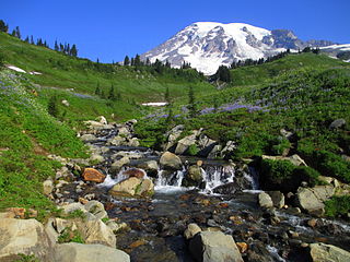
Mount Rainier National Park is an American national park located in southeast Pierce County and northeast Lewis County in Washington state. The park was established on March 2, 1899, as the fourth national park in the United States, preserving 236,381 acres including all of Mount Rainier, a 14,410-foot (4,390 m) stratovolcano. The mountain rises abruptly from the surrounding land with elevations in the park ranging from 1,600 feet to over 14,000 feet (490–4,300 m). The highest point in the Cascade Range, Mount Rainier is surrounded by valleys, waterfalls, subalpine meadows, and 91,000 acres of old-growth forest. More than 25 glaciers descend the flanks of the volcano, which is often shrouded in clouds that dump enormous amounts of rain and snow.

The Continental Divide National Scenic Trail is a United States National Scenic Trail with a length measured by the Continental Divide Trail Coalition of 3,028 miles (4,873 km) between the U.S. border with Chihuahua, Mexico and the border with Alberta, Canada. Frequent route changes and a large number of alternate routes result in an actual hiking distance of 2,700 miles (4,300 km) to 3,150 miles (5,070 km). The CDT follows the Continental Divide of the Americas along the Rocky Mountains and traverses five U.S. states — Montana, Idaho, Wyoming, Colorado, and New Mexico. In Montana near the Canadian border the trail crosses Triple Divide Pass.

Glacier National Park is an American national park located in northwestern Montana, on the Canada–United States border, adjacent to the Canadian provinces of Alberta and British Columbia. The park encompasses more than 1 million acres (4,000 km2) and includes parts of two mountain ranges, more than 130 named lakes, more than 1,000 different species of plants, and hundreds of species of animals. This vast pristine ecosystem is the centerpiece of what has been referred to as the "Crown of the Continent Ecosystem," a region of protected land encompassing 16,000 sq mi (41,000 km2).

The Mist Trail is one of the most popular short hikes in Yosemite National Park, California, USA. The steep hike follows the Merced River, starting at Happy Isles in Yosemite Valley, past Vernal Fall and Emerald Pool, to Nevada Fall.

Glacier Point is a viewpoint above Yosemite Valley in the U.S. state of California. It is located on the south wall of Yosemite Valley at an elevation of 7,214 feet (2,199 m), 3,200 feet (980 m) above Curry Village. The point offers a superb view of several of Yosemite National Park's well-known landmarks, including Yosemite Valley, Yosemite Falls, Half Dome, Vernal Fall, Nevada Fall, and Clouds Rest. Between 1872 and 1968, it was the site of the Yosemite Firefall.

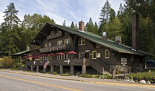
The Lake McDonald Lodge is a historic lodge located within Glacier National Park, on the southeast shore of Lake McDonald. The lodge is a 3+1⁄2-story structure built in 1913 based on Kirtland Cutter's design. The foundation and first floor walls are built of stone, with a wood-frame superstructure. The lobby is a large, open space that extends to the third story. It has a massive fireplace and a concrete floor scored in a flagstone pattern, with messages in several Indian languages inscribed into it. The rustic lodge was designated a National Historic Landmark in 1987 as one of the nation's finest examples of large-scale Swiss chalet architecture. Lake McDonald Lodge is a member of Historic Hotels of America, the official program of the National Trust for Historic Preservation.

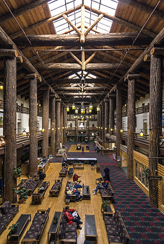
Many Glacier Hotel is a historic hotel located on the east shore of Swiftcurrent Lake in Glacier National Park in the U.S. state of Montana. The building is designed as a series of chalets, up to four stories tall, and stretches for a substantial distance along the lakeshore. The building has a Swiss alpine theme both on the outside and on the inside. The foundation is made of stone, with a wood superstructure. The outside is finished with brown-painted wood siding, and the window framing and balconies have wood sawed in Swiss jigsawed patterns. On the inside, the four-story lobby is surrounded by balconies, whose railings are patterned after Swiss designs.

Two Medicine is the collective name of a region located in the southeastern section of Glacier National Park, in the U.S. state of Montana. It has a campground alongside Two Medicine Lake. From the period starting in the late 1890s until the completion of the Going-to-the-Sun Road in 1932, Two Medicine was one of the most visited sections of the park. Once part of a larger chalet complex, the Two Medicine Store is located along the shores of Two Medicine Lake and the building is a National Historic Landmark. The region is a starting point for many trails and tourboats take visitors out on Two Medicine Lake, where the steep south face of Rising Wolf Mountain towers above the lake. The region was considered sacred ground by several Native American tribes including the Blackfeet and they performed Vision quests here. Aside from Chief Mountain, the Two Medicine area is the most sacred section of the park to the Blackfeet.

Many Glacier is an area within Glacier National Park in the U.S. state of Montana. The Many Glacier region is located north of the Going-to-the-Sun Road, on the east side of the park. Lake Sherburne is the large lake in the area and the Many Glacier Hotel, the largest hotel within the park, is along the shore of the adjacent Swiftcurrent Lake. The hotel and surrounding buildings are a National Historic Landmark, with original construction dating back to 1915. Many Glacier is surrounded by the high peaks of the Lewis Range, and many hiking trails can be accessed from the area. The region is noted for numerous lakes, waterfalls and dense coniferous forests interspersed with alpine meadows. Major sites in the immediate vicinity that can be accessed by trails include Lake Josephine, Grinnell Lake, Grinnell Glacier, Cracker Lake, Granite Park Chalet, Iceberg Cirque and the Ptarmigan Tunnel, a hiking tunnel carved through the mountainside during the 1930s. Tour boats allow visitors an opportunity to venture onto Swiftcurrent Lake. Other activities in the region include ranger-guided nature hikes, horseback riding, fishing and camping.

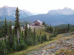
Sperry Chalet is located about seven miles east of Lake McDonald in Glacier National Park in the U.S. state of Montana. The chalet was opened in 1914 by the Great Northern Railway and was a National Historic Landmark contributing property, being one of five structures in the Great Northern Railway Buildings National Historic Landmark. Along with Granite Park Chalet, Sperry Chalet is one of the two remaining backcountry chalets in Glacier National Park, both operated by Belton Chalets, Inc.
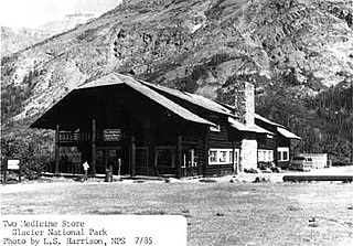
Two Medicine Store, formerly part of Two Medicine Chalets, is a historic building in Glacier National Park in the U.S. state of Montana. The chalet was originally built in 1914 by the Glacier Park Hotel Company, a subsidiary of the Great Northern Railway, as part of the railway's extensive program of visitor services development at Glacier. The chalet group originally featured a complex of log buildings, all built in the rustic style, which provided dining and lodging facilities. Overnight accommodations at the chalet ended with the onset of World War II, and the other buildings at the site were intentionally burned in 1956.

The Highline Trail is a scenic hiking trail in Glacier National Park, Montana, United States. The trail stretches 7.6 miles (12.2 km) from Logan Pass to Granite Park Chalet, and continues another 11.9 miles (19.2 km) from there to Fifty Mountain Campground. The trail follows the Garden Wall ridge and the continental divide for most of its length. The trail offers scenic views of glaciated U-shaped valleys. A 1.2-mile (1.9 km) round trip side trail takes hikers up the side of the Garden Wall to an overlook to Grinnell Glacier.

West Glacier is an unincorporated community and census-designated place (CDP) in eastern Flathead County, Montana, United States. As of the 2010 census it had a population of 227. The town is at the west entrance to Glacier National Park and is located on U.S. Route 2 and a main line of the BNSF Railway. The headquarters complex for Glacier National Park is located nearby.

National Park Service rustic – sometimes colloquially called Parkitecture – is a style of architecture that developed in the early and middle 20th century in the United States National Park Service (NPS) through its efforts to create buildings that harmonized with the natural environment. Since its founding in 1916, the NPS sought to design and build visitor facilities without visually interrupting the natural or historic surroundings. The early results were characterized by intensive use of hand labor and a rejection of the regularity and symmetry of the industrial world, reflecting connections with the Arts and Crafts movement and American Picturesque architecture.
The Belton Chalets are a group of historic hotel buildings in the village of West Glacier, Montana, near the western entrance to Glacier National Park. The chalet buildings were built in 1910-11 by the Great Northern Railway (GN) as the first component of the railroad's ambitious program of hotel, road, and trail construction in Glacier. The buildings featured a "Swiss Chalet" architectural style that set the style for much of the Great Northern's building program in Glacier. Ultimately, the site included five buildings, including a dining hall and a hotel facility.

The Uinta Highline Trail is a trail in the Uinta Mountains of Utah that traverses the range 104 miles (167 km) from east to west. The trail passes through expansive alpine landscapes dominated by metasedimentary rocks sculpted by past glaciers. The broad glacial basins are dotted by hundreds of lakes.
Babb is a small unincorporated farming and ranching community in Glacier County, Montana, United States, on the Blackfeet Indian Reservation. The community experiences a large influx of tourists in the summer months as it is the gateway to the Many Glacier area of Glacier National Park. For statistical purposes, the United States Census Bureau has defined Babb as a census-designated place (CDP). It had a population of 174 at the 2010 census.

The Great Northern Railway Buildings are a set of five building complexes in or near Glacier National Park in Montana. They were built by the Great Northern Railway during the period of the park's founding to provide a unified tourist experience to visitors to the park, using the Swiss chalet as a building model. The building complexes, each separately listed on the National Register of Historic Places, are:

The Glacier National Park Tourist Trails, including the Inside Trail, South Circle Trail and North Circle Trail, were established in Glacier National Park to connect a series of tourist camps and hotels established by the Great Northern Railway between 1910 and 1915. Prior to the construction of the Going-to-the-Sun Road, these trails were the primary form of circulation within the park. The trail system includes a number of bridges.