Related Research Articles
Sunfield Township is a civil township of Eaton County in the U.S. state of Michigan. The population was 1,997 at the 2010 census, down from 2,177 at the 2000 census.
Montreal is an unincorporated community in southeast Camden County, Missouri, United States. It is located approximately eight miles east-southeast of Camdenton and 12 miles northwest of Richland on Route 7.

Iantha is an unincorporated community in Barton County, Missouri. It is located six miles west of Lamar.
Dawn is an unincorporated community and census-designated place (CDP) in Livingston County, Missouri, United States. As of the 2020 census it had a population of 100.
Ravanna is a census-designated place in Mercer County, Missouri, United States. It is located approximately seven miles northeast of Princeton on U.S. Route 136. The population was 60 at the 2020 census.
Buell is an unincorporated community in northern Montgomery County, Missouri, United States. It is located approximately five miles northeast of Montgomery City on Route 161.

Hollywood is an unincorporated community in southern Dunklin County, Missouri, United States. It is located less than one mile from Route 164, approximately twelve miles south of Kennett.

Millersville is an unincorporated community in western Cape Girardeau County, Missouri, United States. It is located six miles (10 km) west of Jackson on Route 72.
Prairie Hill is an unincorporated community in eastern Chariton County, Missouri, United States. The community is located at the intersection of Missouri routes W and HH approximately seven miles north-northeast of Salisbury. The Thomas Hill Reservoir dam is seven miles to the northeast in adjacent Randolph County.

Hemple is an unincorporated community in northwestern Clinton County, Missouri and is part of the Kansas City metropolitan area within the United States. It is located approximately 3.5 miles southwest of Stewartsville in Dekalb County and four miles east of Easton in Buchanan County.

Chesapeake is an unincorporated community and census-designated place in Lawrence County, Missouri, United States. It is located on Route 174, approximately five miles east of Mount Vernon.

Eureka is an unincorporated community and census-designated place (CDP) in Clinton County in the U.S. state of Michigan. The population of the CDP was 233 at the 2020 census. The community is located within Greenbush Township.
Caput is an extinct town in Barton County, in the U.S. state of Missouri. The town site is approximately five miles northwest of Lamar.
Paradise is an unincorporated community in northwest Clay County, in the U.S. state of Missouri. The community lies between the two arms of the Smithville Lake on the Little Platte River. The city of Smithville lies across the lake to the southwest. The community is located along Missouri Route W about four miles southeast of Trimble in adjacent Clinton County.
Haynesville is an unincorporated community in southern Clinton County, in the U.S. state of Missouri. The community lies about one quarter mile east of I-35 and north of Missouri Route PP. The community of Holt is located approximately two miles to the southwest on the west side of I-35 in northern Clay County.
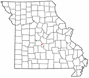
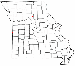
Starfield is an unincorporated community in Lafayette Township in western Clinton County, in the U.S. state of Missouri. The community is on Missouri Route K and Castile Creek. The city of Gower is 4.5 miles to the southwest and Plattsburg is 6.5 miles to the southeast. Northwest Starfield Road bears its namesake.
Carlow is an unincorporated community in southeast Daviess County, in the U.S. state of Missouri.
Frisbee is an unincorporated community and Census-designated place in Dunklin County, in the U.S. state of Missouri.
Good Water is an unincorporated community in northwest Iron County, in the U.S. state of Missouri.
New Market is a census designated place in northern Platte County, in the U.S. state of Missouri. It lies within the Kansas City metropolitan area. The population was 88 at the 2020 census.
References
- ↑ "ArcGIS REST Services Directory". United States Census Bureau. Retrieved September 5, 2022.
- 1 2 U.S. Geological Survey Geographic Names Information System: Grayson, Missouri
- ↑ Missouri Atlas & Gazetteer, DeLorme, 1st ed., 1998, p. 27 ISBN 0899332242
- ↑ "Clinton County Place Names, 1928–1945 (archived)". The State Historical Society of Missouri. Archived from the original on 24 June 2016. Retrieved 21 September 2016.
{{cite web}}: CS1 maint: bot: original URL status unknown (link) - ↑ U.S. Geological Survey Geographic Names Information System: Grayson, Missouri
- ↑ "Post Offices". Jim Forte Postal History. Retrieved 21 September 2016.
- ↑ "Census of Population and Housing". Census.gov. Retrieved June 4, 2016.
Municipalities and communities of Clinton County, Missouri, United States | ||
|---|---|---|
| Cities |  | |
| Village | ||
| Townships | ||
| CDPs | ||
| Other communities | ||
| Footnotes | ‡This populated place also has portions in an adjacent county or counties | |
| | This Clinton County, Missouri state location article is a stub. You can help Wikipedia by expanding it. |