
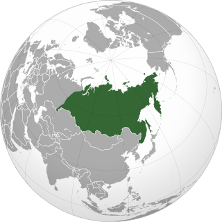
The Great Russian Regions are eight geomorphological areas in the Russian Federation displaying characteristic forms of relief. Seven of them are east of the Urals. [1]
The Great Russian Regions are eight geomorphological areas in the Russian Federation displaying characteristic forms of relief. Seven of them are east of the Urals. [1]
 |  |  |
 |  |  |
 |  |  |

Russia is the largest country in the world, covering over 17,125,192 km2 (6,612,074 sq mi), and encompassing more than one-eighth of Earth's inhabited land area. Russia extends across eleven time zones, and has the most borders of any country in the world, with sixteen sovereign nations.
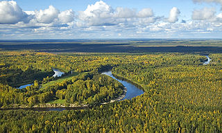
Siberia is an extensive geographical region comprising all of North Asia, from the Ural Mountains in the west to the Pacific Ocean in the east. It has formed part of the sovereign territory of Russia and its predecessor states since the centuries-long conquest of Siberia, which began with the fall of the Khanate of Sibir in the late 16th century and concluded with the annexation of Chukotka in 1778. Siberia is vast and sparsely populated, covering an area of over 13.1 million square kilometres (5,100,000 sq mi), but home to roughly a quarter of Russia's population. Novosibirsk, Krasnoyarsk, and Omsk are the largest cities in the area.
North Asia or Northern Asia, also referred to as Siberia, is the northern region of Asia, which is defined in geographical terms and is coextensive with the Asian part of Russia and consists of three federal districts of Russia: Ural, Siberian, and the Far Eastern. North Asia is bordered by the Arctic Ocean to its north; by Eastern Europe to its west; by Central and East Asia to its south; and by the Pacific Ocean and North America to its east. It covers an area of 13,100,000 square kilometres (5,100,000 sq mi), or 8.8% of Earth's total land area; and is the largest subregion of Asia by area, but is also the least populated, with a population of around 37 million, accounting for merely 0.74% of Asia's population.

The Lena is a river in the Russian Far East, and is the easternmost of the three great Siberian rivers that flow into the Arctic Ocean. The Lena is the eleventh-longest river in the world, and the longest river entirely within Russia, with a length of 4,294 km (2,668 mi) and a drainage basin of 2,490,000 km2 (960,000 sq mi). Permafrost underlies most of the catchment, 77% of which is continuous.
The West Siberian Plain is a large plain that occupies the western portion of Siberia, between the Ural Mountains in the west and the Yenisei River in the east, and the Altai Mountains on the southeast. Much of the plain is poorly drained and consists of some of the world's largest swamps and floodplains. Important cities include Chelyabinsk, Novosibirsk, Omsk, and Tomsk, as well as Surgut and Nizhnevartovsk.

The Central Siberian Plateau is a vast mountainous area in Siberia, one of the Great Russian Regions.
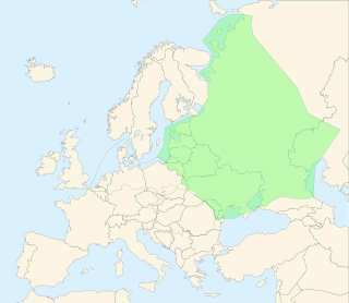
The East European Plain is a vast interior plain extending east of the North European Plain, and comprising several plateaus stretching roughly from 25 degrees longitude eastward. It includes Volhynian-Podolian Upland on its westernmost fringe, the Central Russian Upland, and, on the eastern border, encompasses the Volga Upland. The plain includes also a series of major river basins such as the Dnepr Basin, the Oka–Don Lowland, and the Volga Basin. At the southeastern point of the East European Plain are the Caucasus and Crimean mountain ranges. Together with the North European Plain, and covering the Baltic states, European Russia, Belarus, Ukraine, Moldova, southeastern Romania, and, at its southernmost point, the Danubian Plain in Northern Bulgaria, it constitutes the majority of the Great European Plain, the greatest mountain-free part of the European landscape. The plain spans approximately 4,000,000 km2 (2,000,000 sq mi) and averages about 170 m (560 ft) in elevation. The highest point of the plain, located in the Valdai Hills, is 346.9 metres (1,138.1 ft).

The Vilyuy is a river in Russia, the longest tributary of the Lena. About 2,650 kilometres (1,650 mi) long, it flows mostly within the Sakha Republic. Its basin covers about 454,000 square kilometres (175,000 sq mi).
Siberian natural resources refers to resources found in Russian Siberia, in the North Asian Mainland. The Siberian region is rich in resources, including coal, oil and metal ores.

The following outline is provided as an overview of and topical guide to Russia.
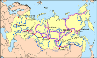
Siberian River Routes were the main ways of communication in Russian Siberia before the 1730s, when roads began to be built. The rivers were also of primary importance in the process of Russian conquest and exploration of vast Siberian territories eastwards. Since the three great Siberian rivers, the Ob, the Yenisey, and the Lena all flow into the Arctic Ocean, the aim was to find parts or branches of these rivers that flow approximately east-west and find short portages between them. Since Siberia is relatively flat, portages were usually short. Despite resistance from the Siberian tribes, Russian Cossacks were able to expand from the Urals to the Pacific in only 57 years (1582-1639). These river routes were crucial in the first years of the Siberian fur trade as the furs were easier to transport over water than land. The rivers connected the major fur gathering centers and provided for relatively quick transport between them.

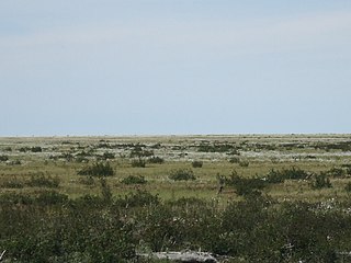
The North Siberian Lowland, also known as Taymyr Lowland, is a plain with a relatively flat relief separating the Byrranga Mountains of the Taymyr Peninsula in the north from the Central Siberian Plateau in the south. To the southeast of the Olenyok basin the lowland merges with the Central Yakutian Lowland.

Central Siberia Nature Reserve is a Russian 'zapovednik'. With over 1 million hectares of protected area, it is one of the largest forest reserves in the world. The reserve is located in the middle Yenisei, lower Bakhta and lower Stony Tunguska river valleys, of the Central Siberian Plateau. Notably, the territory covers both banks of the Yenisei for over 60 km. The reserve is situated in the Turukhansky District of Krasnoyarsk Krai.

The West Siberian taiga ecoregion covers the West Siberian Plain in Russia, from the Ural mountains in the west to the Yenisei River in the east, and roughly from 56° N to 66° N latitude. It is a vast, flat lowland region of boreal forests (taiga), and wetlands, covering an area about 1,800 km west–east, by 1,000 km north–south.

The Taimyr-Central Siberian tundra ecoregion is an ecoregion that broadly covers the Taymyr Peninsula in the Russian Far North. It ranges from the delta of the Yenisei River in the west, across the Taymyr Peninsula and Khatanga Gulf, to the Lena River delta in the east. The region is an important area for breeding birds. It is in the Palearctic realm in the tundra biome, and is mostly located in Taymyrsky Dolgano-Nenetsky District of Krasnoyarsk Krai. It has an area of 954,670 square kilometres (368,600 sq mi).
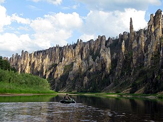
The Lena Plateau, also known as Prilensky Plateau, is one of the great plateaus of Siberia. Administratively it is mostly within the Sakha Republic (Yakutia), with a small sector in the Irkutsk Oblast, Far Eastern Federal District, Russia. The plateau is named after the Lena River, which flows across it.

The Central Yakutian Lowland or Central Yakutian Lowlands, also known as Central Yakut Plain or Vilyuy Lowland, is a low alluvial plain in Siberia, Russia.
The East Siberian Lowland, also known as Yana-Kolyma Lowland, is a vast plain in North-eastern Siberia, Russia. The territory of the lowland is one of the Great Russian Regions. Administratively, it is a part of the Sakha Republic (Yakutia).

The South Siberian Mountains are one of the largest mountain systems of the Russian Federation. The total area of the system of mountain ranges is more than 1.5 million km². The South Siberian Mountains are located in the Siberian and Far Eastern Federal Districts of Russia, as well as partly in Mongolia. The territory of the mountain system is one of the Great Russian Regions.

The East Siberian Mountains or East Siberian Highlands are one of the largest mountain systems of the Russian Federation. They are located between the Central Yakutian Lowland and the Bering Strait in Northeast Siberia. The area of the East Siberian Mountains has a very low population density. The territory of the mountain system is one of the Great Russian Regions.
| Branches |
| ||||||||
|---|---|---|---|---|---|---|---|---|---|
| Techniques and tools |
| ||||||||
| Institutions | |||||||||
| Education | |||||||||
 | ||