Greene County | |
---|---|
Coordinates: 31°13′N88°38′W / 31.22°N 88.64°W | |
Country | United States |
State | Mississippi |
Founded | 1811 |
Named for | Nathanael Greene |
Seat | Leakesville |
Largest town | Leakesville |
Area | |
• Total | 719 sq mi (1,860 km2) |
• Land | 713 sq mi (1,850 km2) |
• Water | 5.9 sq mi (15 km2) 0.8% |
Population (2020) | |
• Total | 13,530 |
• Density | 19/sq mi (7.3/km2) |
Time zone | UTC−6 (Central) |
• Summer (DST) | UTC−5 (CDT) |
Congressional district | 4th |
Website | www |
Greene County is a county located on the southeast border of the U.S. state of Mississippi. As of the 2020 census, the population was 13,530. [1] Its county seat is Leakesville. [2] Established in 1811, the county was named for General Nathanael Greene of the American Revolutionary War. [3]
Historically this area of the state was occupied by the Choctaw people, who constituted the largest tribe. French, Spanish and English colonists traded with them in the early colonial years. in 1830, President Andrew Jackson gained passage of the Indian Removal Act by Congress, and proceeded to force the Choctaw and other of the Five Civilized Tribes out of the Southeast to lands west of the Mississippi River. The land was sold to European-American settlers.
County boundaries went through numerous changes as population increased and new counties were created. Along with neighboring Jones and Perry counties, Greene is characterized by its sandy soil and Piney Woods. These characteristics limited the productivity of farming. [4]
The county economy originally depended on subsistence farmers who ran herds of cattle and hogs, which were allowed to roam freely in the pine forests and bush. Together with the game they hunted, residents sold the meat animals to markets in Mobile, Alabama, the nearest commercial center. [5] While some farmers tried to cultivate cotton because of the high prices when the market was strong, most in this area had small farms and the owners held few enslaved African Americans. The soil did not support very successful cotton crops; in 1860 only 16 of the 213 farmers in this county raised cotton. [4]
According to the U.S. Census Bureau, the county has a total area of 719 square miles (1,860 km2), of which 713 square miles (1,850 km2) is land and 5.9 square miles (15 km2) (0.8%) is water. [6]
The rural county had strong declines in population from 1940 to 1960, a period when many African Americans left for the West Coast in the second wave of the Great Migration. The buildup of defense industries in California and other states before and during World War II attracted many migrants for work opportunities.
Census | Pop. | Note | %± |
---|---|---|---|
1820 | 1,345 | — | |
1830 | 1,854 | 37.8% | |
1840 | 1,636 | −11.8% | |
1850 | 2,018 | 23.3% | |
1860 | 2,232 | 10.6% | |
1870 | 2,038 | −8.7% | |
1880 | 3,194 | 56.7% | |
1890 | 3,906 | 22.3% | |
1900 | 6,795 | 74.0% | |
1910 | 6,050 | −11.0% | |
1920 | 10,430 | 72.4% | |
1930 | 10,644 | 2.1% | |
1940 | 9,512 | −10.6% | |
1950 | 8,215 | −13.6% | |
1960 | 8,366 | 1.8% | |
1970 | 8,545 | 2.1% | |
1980 | 9,827 | 15.0% | |
1990 | 10,220 | 4.0% | |
2000 | 13,299 | 30.1% | |
2010 | 14,400 | 8.3% | |
2020 | 13,530 | −6.0% | |
2023 (est.) | 13,601 | [7] | 0.5% |
U.S. Decennial Census [8] 1790-1960 [9] 1900-1990 [10] 1990-2000 [11] 2010-2013 [12] |
As of the census [13] of 2000, there were 13,299 people, 4,148 households, and 3,152 families residing in the county. The population density was 19 people per square mile (7.3 people/km2). There were 4,947 housing units at an average density of 7 units per square mile (2.7 units/km2). The racial makeup of the county was 72.79% White, 26.18% Black or African American, 0.23% Native American, 0.07% Asian, 0.03% Pacific Islander, 0.31% from other races, and 0.38% from two or more races. 0.80% of the population were Hispanic or Latino of any race.
There were 4,148 households, out of which 37.20% had children under the age of 18 living with them, 61.20% were married couples living together, 11.90% had a female householder with no husband present, and 24.00% were non-families. 22.00% of all households were made up of individuals, and 9.30% had someone living alone who was 65 years of age or older. The average household size was 2.67 and the average family size was 3.12.
In the county, the population was spread out, with 24.10% under the age of 18, 13.10% from 18 to 24, 32.10% from 25 to 44, 20.60% from 45 to 64, and 10.10% who were 65 years of age or older. The median age was 32 years. For every 100 females there were 130.00 males. For every 100 females age 18 and over, there were 141.00 males.
The median income for a household in the county was $28,336, and the median income for a family was $33,037. Males had a median income of $30,189 versus $17,935 for females. The per capita income for the county was $11,868. About 16.50% of families and 19.60% of the population were below the poverty line, including 25.30% of those under age 18 and 21.10% of those age 65 or over.
As of 2015 [update] the largest self-reported ancestry groups in Greene County, Mississippi are:
Race | Num. | Perc. |
---|---|---|
White (non-Hispanic) | 9,809 | 72.5% |
Black or African American (non-Hispanic) | 3,143 | 23.23% |
Native American | 60 | 0.44% |
Asian | 21 | 0.16% |
Pacific Islander | 3 | 0.02% |
Other/Mixed | 323 | 2.39% |
Hispanic or Latino | 171 | 1.26% |
As of the 2020 United States census, there were 13,530 people, 3,925 households, and 2,624 families residing in the county.
The Mississippi Department of Corrections South Mississippi Correctional Institution is located in an unincorporated area of Greene County. [16] [17] It opened in 1990. In the early 21st century, it has an inmate population of more than 3,000 men, which has added markedly to the total population of the county. Its inmates constitute approximately 21 percent of the state's total prisoners. Numerous residents of the rural county are employed at the prison.
The Greene County School District includes: Greene County High School, Greene County Vocational-Technical School, Leakesville Elementary School, Leakesville Junior High School, McLain Attendance Center, and Sand Hill Attendance Center. [18]
Year | Republican | Democratic | Third party | |||
---|---|---|---|---|---|---|
No. | % | No. | % | No. | % | |
2020 | 4,794 | 82.48% | 966 | 16.62% | 52 | 0.89% |
2016 | 4,335 | 80.74% | 974 | 18.14% | 60 | 1.12% |
2012 | 4,531 | 76.51% | 1,325 | 22.37% | 66 | 1.11% |
2008 | 4,361 | 75.33% | 1,366 | 23.60% | 62 | 1.07% |
2004 | 3,850 | 72.66% | 1,421 | 26.82% | 28 | 0.53% |
2000 | 3,082 | 69.48% | 1,317 | 29.69% | 37 | 0.83% |
1996 | 1,947 | 53.71% | 1,347 | 37.16% | 331 | 9.13% |
1992 | 2,406 | 51.90% | 1,664 | 35.89% | 566 | 12.21% |
1988 | 2,837 | 57.08% | 1,637 | 32.94% | 496 | 9.98% |
1984 | 2,744 | 67.55% | 1,297 | 31.93% | 21 | 0.52% |
1980 | 1,772 | 50.04% | 1,740 | 49.14% | 29 | 0.82% |
1976 | 1,538 | 40.80% | 2,127 | 56.42% | 105 | 2.79% |
1972 | 2,884 | 83.52% | 513 | 14.86% | 56 | 1.62% |
1968 | 132 | 3.97% | 449 | 13.50% | 2,744 | 82.53% |
1964 | 1,845 | 89.52% | 216 | 10.48% | 0 | 0.00% |
1960 | 247 | 15.65% | 550 | 34.85% | 781 | 49.49% |
1956 | 351 | 28.56% | 734 | 59.72% | 144 | 11.72% |
1952 | 506 | 28.86% | 1,247 | 71.14% | 0 | 0.00% |
1948 | 14 | 1.38% | 118 | 11.59% | 886 | 87.03% |
1944 | 109 | 10.73% | 907 | 89.27% | 0 | 0.00% |
1940 | 66 | 6.65% | 926 | 93.35% | 0 | 0.00% |
1936 | 46 | 5.23% | 830 | 94.43% | 3 | 0.34% |
1932 | 29 | 3.42% | 818 | 96.46% | 1 | 0.12% |
1928 | 342 | 36.58% | 593 | 63.42% | 0 | 0.00% |
1924 | 31 | 6.37% | 456 | 93.63% | 0 | 0.00% |
1920 | 24 | 6.59% | 337 | 92.58% | 3 | 0.82% |
1916 | 32 | 7.36% | 399 | 91.72% | 4 | 0.92% |
1912 | 13 | 4.18% | 268 | 86.17% | 30 | 9.65% |
Greene County School District is the only school district. [20]
Sheridan County is a county in the U.S. state of Wyoming. As of the 2020 United States Census, the population was 30,921. The county seat is Sheridan. Its northern boundary abuts the Montana state border.
Walthall County is a county located in the U.S. state of Mississippi. As of the 2020 census, the population was 13,884. Its county seat is Tylertown. The county is named after Civil War Confederate general and Mississippi Senator Edward C. Walthall.
Pontotoc County is a county located in the U.S. state of Mississippi. As of the 2020 census, the population was 31,184. Its county seat is Pontotoc. It was created on February 9, 1836, from lands ceded to the United States under the Chickasaw Cession. Pontotoc is a Chickasaw word meaning "land of hanging grapes". The original Natchez Trace and the current-day Natchez Trace Parkway both pass through the southeast corner of Pontotoc County.
Madison County is a county located in the U.S. state of Mississippi. As of the 2020 census, the population was 109,145. The county seat is Canton. The county is named for Founding Father and U.S. President James Madison.
Lee County is a county in U.S. state of Mississippi. At the 2020 census, the population was 83,343. Lee County is included in the Tupelo Micropolitan Statistical Area.
Leake County is a county in the center of the U.S. state of Mississippi. As of the 2020 census, the population was 21,275. Its county seat is Carthage. The county is named for Walter Leake, the Governor of Mississippi from 1822 to 1825.
Lauderdale County is a county located on the eastern border of the U.S. state of Mississippi. As of the 2020 census, the population was 72,984. The county seat is Meridian. The county is named for Colonel James Lauderdale, who was killed at the Battle of New Orleans in the War of 1812. Lauderdale County is included in the Meridian, MS Micropolitan Statistical Area.
Itawamba County is a county located in the U.S. state of Mississippi. As of the 2020 United States Census, the population was 23,863. Its county seat is Fulton. The county is part of the Tupelo, MS Micropolitan Statistical Area.
Humphreys County is a county located in the U.S. state of Mississippi. As of the 2020 census, the population was 7,785. Its county seat is Belzoni. The county is named for Benjamin G. Humphreys. Humphreys County is Mississippi's newest county, having been formed in 1918. Humphreys County is located in the Mississippi Delta region.
Calhoun County is a county located in the U.S. state of Mississippi. As of the 2020 census, the population was 13,266. Its county seat is Pittsboro. The county is named after John C. Calhoun, the U.S. Vice President and U.S. Senator from South Carolina.
Benton County is a county located in the U.S. state of Mississippi. As of the 2020 census, the population was 7,646. Its county seat is Ashland.
Craighead County is a county located in the U.S. state of Arkansas. As of the 2020 census, the population was 111,231. The county has two county seats — Jonesboro and Lake City. Craighead County is Arkansas's 58th county, formed on February 19, 1859, and named for state Senator Thomas Craighead. It is one of several dry counties within the state of Arkansas, in which the sale of alcoholic beverages is largely prohibited.
Ackerman is a town in Choctaw County, Mississippi, United States. The population was 1,594 according to 2020 census, which shows an increase from 1,510 reported in the 2010 census It is the county seat of Choctaw County.
Leakesville is a town in and the county seat of Greene County, Mississippi, United States. It is located along the Chickasawhay River in Greene County, Mississippi, United States. It is served by the junction of Mississippi routes 57 and 63. As of the 2010 census, the rural town population was 898, down from 1,026 at the 2000 census.
McLain is a town in Greene County, Mississippi, United States. The population was 441 at the 2010 census, down from 603 at the 2000 census.
De Kalb is a town in and the county seat of Kemper County, Mississippi, United States. The population was 1,164 at the 2010 census. De Kalb is named after General Johann de Kalb, a Franconian-French military officer who served as a major general in the Continental Army during the American Revolutionary War.
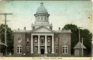
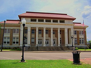
Forest is a city and the county seat of Scott County, Mississippi, United States. The population was 5,684 at the 2010 census and the population is a minority-majority.
Franklin Township is a township in Greene County, Pennsylvania, United States. The population was 7,062 at the 2020 census, down from 7,280 at the 2010 census.
State Line is a town in Greene and Wayne counties, Mississippi, in the United States. The population was 452 at the 2020 census.
Bogue Chitto is a census-designated place (CDP) situated in Kemper and Neshoba counties, Mississippi. The population was 864 at the 2020 census. It is part of the Mississippi Band of Choctaw Indians Reservation and the population is 93% Choctaw.