Greenwood, Mississippi | |
---|---|
Coordinates: 33°31′7″N90°11′2″W / 33.51861°N 90.18389°W | |
Country | United States |
State | Mississippi |
County | Leflore |
Government | |
• Mayor | Carolyn McAdams (I) |
Area | |
• Total | 12.69 sq mi (302.87 km2) |
• Land | 12.34 sq mi (301.95 km2) |
• Water | 0.36 sq mi (0.92 km2) |
Elevation | 131 ft (40 m) |
Population (2020) | |
• Total | 14,490 |
• Density | 1,174.71/sq mi (453.56/km2) |
Time zone | UTC−6 (Central (CST)) |
• Summer (DST) | UTC−5 (CDT) |
ZIP codes | 38930, 38935 |
Area code | 662 |
FIPS code | 28-29340 |
GNIS feature ID | 0670714 |
Website | www |
Greenwood is a city in and the county seat of Leflore County, Mississippi, United States, [2] located at the eastern edge of the Mississippi Delta region, approximately 96 miles north of the state capital, Jackson, and 130 miles south of the riverport of Memphis, Tennessee. It was a center of cotton planter culture in the 19th century.
The population was 15,205 at the 2010 census. It is the principal city of the Greenwood Micropolitan Statistical Area. Greenwood developed at the confluence of the Tallahatchie and the Yalobusha rivers, which form the Yazoo River.
This section needs additional citations for verification .(June 2018) |
The flood plain of the Mississippi River has long been an area rich in vegetation and wildlife, fed by the Mississippi and its numerous tributaries. Long before Europeans migrated to America, the Choctaw and Chickasaw Indian nations settled in the Delta's bottomlands and throughout what is now central Mississippi. They were descended from indigenous peoples who had lived in the area for thousands of years. The Mississippian culture had built earthwork mounds in this area and throughout the Mississippi Valley, beginning about 950 CE. Their culture thrived for hundreds of years.
In the nineteenth century, the Five Civilized Tribes in the Southeast suffered increasing encroachment on their territory by European-American settlers from the United States. Under pressure from the United States government, in 1830 the Choctaw principal chief Greenwood LeFlore and other Choctaw leaders signed the Treaty of Dancing Rabbit Creek, ceding most of their remaining land to the United States in exchange for land in Indian Territory, what is now southeastern Oklahoma. The government opened the land for sale and settlement by European Americans. LeFlore came to regret his decision on land cession, saying in 1843 that he was "sorry to say that the benefits realized from [the treaty] by my people were by no means equal to what I had a right to expect, nor to what they were justly entitled." [3]
The first Euro-American settlement on the banks of the Yazoo River was a trading post founded in 1834 by Colonel Dr. John J. Dilliard [4] : 7 and known as Dilliard's Landing. The settlement had competition from Greenwood Leflore's rival landing called Point Leflore, located three miles up the Yazoo River. The rivalry ended when Captain James Dilliard donated parcels in exchange for a commitment from the townsmen to maintain an all-weather turnpike to the hill section to the east, along with a stagecoach road to the more established settlements to the northwest. [5]
The settlement was incorporated as "Greenwood" in 1844, named after Chief Greenwood LeFlore. The success of the city, founded during a strong international demand for cotton, was based on its strategic location in the heart of the Delta: on the easternmost point of the alluvial plain, and astride the Tallahatchie and Yazoo rivers. The city served as a shipping point for cotton to major markets in New Orleans, Vicksburg, Mississippi, Memphis, Tennessee, and St. Louis, Missouri.[ citation needed ]
The construction of railroads through the area in the 1880s revitalized the city; [4] : 8 two rail lines ran to downtown Greenwood close to the Yazoo River, and shortened transportation to markets. Greenwood again emerged as a prime shipping point for cotton. Downtown's Front Street, bordering the Yazoo, was dominated by cotton factors and related businesses, earning that section the name "Cotton Row".
The city continued to prosper well into the 1940s. Cotton production suffered in Mississippi during the infestation of the boll weevil in the early 20th century; however, for many years the bridge over the Yazoo displayed the sign "World's Largest Inland Long Staple Cotton Market".
Cotton cultivation and processing became largely mechanized in the first half of the 20th century, displacing thousands of sharecroppers and tenant farmers. Since the late 20th century, some Mississippi farmers have begun to replace cotton with corn and soybeans as commodity crops; with the textile manufacturing industry having shifted overseas, farmers can gain stronger prices for the newer crops, used mostly as animal feed. [6]
Greenwood's Grand Boulevard was once named one of America's 10 most beautiful streets by the U.S. Chambers of Commerce and the Garden Clubs of America. Sally Humphreys Gwin, a charter member of the Greenwood Garden Club, planted the 1,000 oak trees that line Grand Boulevard. In 1950, Gwin received a citation from the National Congress of the Daughters of the American Revolution in recognition of her work in the conservation of trees. [7] [8]
According to the United States Census Bureau, the city has a total area of 9.5 square miles (25 km2), of which 9.2 square miles (24 km2) is land and 0.3 square miles (0.78 km2) is water.
Climate data for Greenwood, Mississippi (Greenwood–Leflore Airport), 1991–2020 normals, extremes 1948–present | |||||||||||||
---|---|---|---|---|---|---|---|---|---|---|---|---|---|
Month | Jan | Feb | Mar | Apr | May | Jun | Jul | Aug | Sep | Oct | Nov | Dec | Year |
Record high °F (°C) | 84 (29) | 84 (29) | 88 (31) | 94 (34) | 100 (38) | 104 (40) | 105 (41) | 106 (41) | 103 (39) | 100 (38) | 89 (32) | 85 (29) | 106 (41) |
Mean maximum °F (°C) | 73.9 (23.3) | 76.7 (24.8) | 82.8 (28.2) | 86.8 (30.4) | 91.7 (33.2) | 95.0 (35.0) | 97.9 (36.6) | 98.8 (37.1) | 96.0 (35.6) | 89.9 (32.2) | 81.8 (27.7) | 75.7 (24.3) | 99.8 (37.7) |
Mean daily maximum °F (°C) | 54.2 (12.3) | 58.8 (14.9) | 67.2 (19.6) | 75.2 (24.0) | 82.9 (28.3) | 89.1 (31.7) | 91.5 (33.1) | 91.9 (33.3) | 87.3 (30.7) | 77.3 (25.2) | 65.7 (18.7) | 57.1 (13.9) | 74.8 (23.8) |
Daily mean °F (°C) | 44.4 (6.9) | 48.3 (9.1) | 56.1 (13.4) | 64.0 (17.8) | 72.3 (22.4) | 79.0 (26.1) | 81.5 (27.5) | 81.1 (27.3) | 75.6 (24.2) | 64.9 (18.3) | 53.8 (12.1) | 47.1 (8.4) | 64.0 (17.8) |
Mean daily minimum °F (°C) | 34.7 (1.5) | 37.9 (3.3) | 45.1 (7.3) | 52.8 (11.6) | 61.7 (16.5) | 68.8 (20.4) | 71.6 (22.0) | 70.4 (21.3) | 63.8 (17.7) | 52.4 (11.3) | 41.9 (5.5) | 37.0 (2.8) | 53.2 (11.8) |
Mean minimum °F (°C) | 16.6 (−8.6) | 21.4 (−5.9) | 27.0 (−2.8) | 35.8 (2.1) | 46.5 (8.1) | 58.6 (14.8) | 63.9 (17.7) | 61.9 (16.6) | 48.0 (8.9) | 33.9 (1.1) | 25.7 (−3.5) | 21.5 (−5.8) | 14.6 (−9.7) |
Record low °F (°C) | −2 (−19) | −4 (−20) | 15 (−9) | 28 (−2) | 35 (2) | 49 (9) | 53 (12) | 52 (11) | 35 (2) | 27 (−3) | 15 (−9) | 2 (−17) | −4 (−20) |
Average precipitation inches (mm) | 4.52 (115) | 5.04 (128) | 4.76 (121) | 5.82 (148) | 4.44 (113) | 3.74 (95) | 3.82 (97) | 3.21 (82) | 3.83 (97) | 3.41 (87) | 3.86 (98) | 5.33 (135) | 51.78 (1,315) |
Average precipitation days (≥ 0.01 in) | 9.6 | 10.0 | 10.7 | 8.9 | 9.8 | 9.0 | 9.3 | 8.2 | 6.0 | 7.4 | 8.3 | 10.2 | 107.4 |
Source: NOAA [9] [10] |
Census | Pop. | Note | %± |
---|---|---|---|
1880 | 308 | — | |
1890 | 1,055 | 242.5% | |
1900 | 3,026 | 186.8% | |
1910 | 5,836 | 92.9% | |
1920 | 7,793 | 33.5% | |
1930 | 11,123 | 42.7% | |
1940 | 14,767 | 32.8% | |
1950 | 18,061 | 22.3% | |
1960 | 20,436 | 13.1% | |
1970 | 22,400 | 9.6% | |
1980 | 20,115 | −10.2% | |
1990 | 18,906 | −6.0% | |
2000 | 18,425 | −2.5% | |
2010 | 15,205 | −17.5% | |
2020 | 14,490 | −4.7% | |
U.S. Decennial Census [11] |
Race | Num. | Perc. |
---|---|---|
White | 3,646 | 25.16% |
Black or African American | 10,198 | 70.38% |
Native American | 7 | 0.05% |
Asian | 154 | 1.06% |
Other/Mixed | 276 | 1.9% |
Hispanic or Latino | 209 | 1.44% |
As of the 2020 United States Census, there were 14,490 people, 4,924 households, and 2,793 families residing in the city.
At the 2010 census, [13] there were 15,205 people and 6,022 households in the city. The population density was 1,237.7 inhabitants per square mile (477.9/km2). There were 6,759 housing units. The racial makeup of the city was 30.4% White, 67.0% Black, 0.1% Native American, 0.9% Asian, <0.1% Pacific Islander, <0.1% from other races, and 0.5% from two or more races. Hispanic or Latino of any race were 1.1% of the population.
Among the 6,022 households, 28.7% had children under the age of 18 living with them, 29.8% were married couples living together, 29.0% had a female householder with no husband present, 4.6% had a male householder with no wife present, and 36.6% were non-families. 32.5% of all households were made up of individuals living alone and 10.7% had someone living alone who was 65 years of age or older. The average household size was 2.48 and the average family size was 3.16.
Radio station WGRM on Howard Street was the location of B.B. King's first live broadcast in 1940. On Sunday nights, King performed live gospel music as part of a quartet. [14] In memory of this event, the Mississippi Blues Trail has placed its third historic marker in this town at the site of the former radio station. [15] [16] Another Mississippi Blues Trail marker is placed near the grave of the blues singer Robert Johnson. [17] A third Blues Trail marker notes the Elks Lodge in the city, which was an important black organization. [18] A fourth Blues Trail marker was dedicated to Hubert Sumlin that is located along the Yazoo River on River Road. [19]
Greenwood is governed under a city council form of government, composed of council members elected from seven single-member wards and headed by a mayor, who is elected at-large.
Greenwood Leflore Consolidated School District (GLCSD) operates public schools. Previously the majority of the city was in Greenwood Public School District while small portions were in the Leflore County School District. [20] These two districts consolidated into GLCSD on July 1, 2019. [21] Greenwood High School is the only public high school in Greenwood. As of 2014, the student body is 99% black. Amanda Elzy High School was formerly of the Leflore County district. It was recently taken over by the State of Mississippi for poor performance as a result of deficient leadership.
Pillow Academy, a private school, is located in unincorporated Leflore County, near Greenwood.
Delta Streets Academy, a newly founded private school located in downtown Greenwood, has an enrollment of nearly 50 students. It has continued to increase enrollment.
St. Francis Catholic School, run by the Roman Catholic Diocese of Jackson, provides classes from kindergarten through sixth grade. [22]
In addition, North New Summit School provides educational services for special-needs and at-risk children from kindergarten through high school.
Nightmare in Badham County (1976), Ode to Billy Joe (1976), and The Help (2011) were filmed in Greenwood. [23] The 1991 movie Mississippi Masala was also set and filmed in Greenwood. [24]
Greenwood is served by two major rail lines. Amtrak, the national passenger rail system, provides service to Greenwood, connecting New Orleans to Chicago from Greenwood station.
Greenwood is served by Greenwood–Leflore Airport (GWO) to the east, and is located midway between Jackson, Mississippi, and Memphis, Tennessee. It is about halfway between Dallas, Texas, and Atlanta, Georgia.
Yazoo County is a county located in the U.S. state of Mississippi. As of the 2020 census, the population was 26,743. The county seat is Yazoo City. It is named for the Yazoo River, which forms its western border. Its name is said to come from a Choctaw language word meaning "River of Death".
Tallahatchie County is a county in the U.S. state of Mississippi. At the 2020 census, the population was 12,715. Its county seats are Charleston and Sumner.
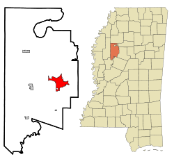
Leflore County is a county located in the U.S. state of Mississippi. As of the 2020 census, the population was 28,339. The county seat is Greenwood. The county is named for Choctaw leader Greenwood LeFlore, who signed a treaty to cede his people's land to the United States in exchange for land in Indian Territory. LeFlore stayed in Mississippi, settling on land reserved for him in Tallahatchie County.
Rosedale is a city in Bolivar County, Mississippi, United States. The population was 1,873 at the 2010 census, down from 2,414 in 2000. Located in an agricultural area, the city had a stop on the Yazoo and Mississippi Valley Railroad, which carried many migrants north out of the area in the first half of the 20th century.
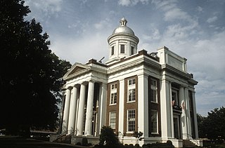
Port Gibson is a city in Claiborne County, Mississippi, United States. The population was 1,567 at the 2010 census. Port Gibson is the county seat of Claiborne County, which is bordered on the west by the Mississippi River. It is the site of the Claiborne County Courthouse.
Clarksdale is a city in and the county seat of Coahoma County, Mississippi, United States. It is located along the Sunflower River. Clarksdale is named after John Clark, a settler who founded the city in the mid-19th century when he established a timber mill and business. Clarksdale is in the Mississippi Delta region and is an agricultural and trading center. Many African-American musicians developed the blues here, and took this original American music with them to Chicago and other northern cities during the Great Migration.
Itta Bena is a city in Leflore County, Mississippi, United States. The population was 2,049 at the 2010 census. The town's name is derived from the Choctaw phrase iti bina, meaning "forest camp". Itta Bena is part of the Greenwood, Mississippi micropolitan area. It developed as a trading center of an area of cotton plantations.
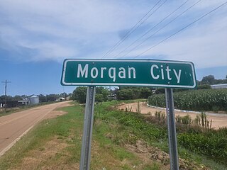
Morgan City, Mississippi is a town in Leflore County along Mississippi Highway 7. The population was 255 at the 2010 census, down from 305 at the 2000 census. It is part of the Greenwood, Mississippi micropolitan area.
Canton is a city in Madison County, Mississippi, United States. The population was 10,948 at the 2020 census, down from 13,189 in 2010. It is the county seat of Madison County, and is situated in the northern part of the metropolitan area surrounding the state capital, Jackson.
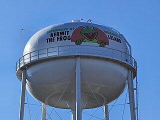
Leland is a city in Washington County, Mississippi, United States. It is located within the Mississippi Delta, on the banks of Deer Creek. The population was 4,481 at the 2010 census. It was once a railway town and had long been a center of cotton culture, which is still an important commodity crop in the rural area. It was once considered the second-largest city in Washington County in 1920 due to its rapid growth of residents, businesses, and schools.
Minter City is an unincorporated community in Leflore County and Tallahatchie County, Mississippi. It is part of the Greenwood, Mississippi micropolitan area, and is within the Mississippi Delta.
The Mississippi Delta, also known as the Yazoo–Mississippi Delta, or simply the Delta, is the distinctive northwest section of the U.S. state of Mississippi that lies between the Mississippi and Yazoo rivers. The region has been called "The Most Southern Place on Earth", because of its unique racial, cultural, and economic history.
The Tallahatchie River is a river in Mississippi which flows 230 miles (370 km) from Tippah County, through Tallahatchie County, to Leflore County, where it joins the Yalobusha River to form the Yazoo River, which ultimately meets the Mississippi River at Vicksburg, Mississippi. The river is navigable for about 100 miles (160 km). At Money, Mississippi, the river's flow measures approximately 7,861 cubic feet per second.
The Yalobusha River is a river, 165 miles (266 km) long, in north-central Mississippi in the United States. It is a principal tributary of the Yazoo River, via which it is part of the watershed of the Mississippi River.
Money is an unincorporated community near Greenwood in Leflore County, Mississippi, United States, in the Mississippi Delta. It has fewer than 100 residents, down from 400 in the early 1950s when a cotton mill operated there. Money is located on a railroad line along the Tallahatchie River, a tributary of the Yazoo River in the eastern part of the Mississippi Delta. The community has ZIP code 38945 in the Greenwood, Mississippi micropolitan area.
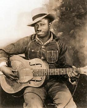
Robert Petway was an American blues singer and guitarist. He recorded only 16 songs, but it has been said that he was an influence on many notable blues and rock musicians, including John Lee Hooker, Muddy Waters, and Jimi Hendrix. There is only one known picture of Petway, a publicity photo from 1941. His birth name may have been Pettyway, Pitway, Petaway, or similar.
Berclair is an unincorporated community located in Leflore County, Mississippi, United States. Berclair is approximately 3 miles (4.8 km) west of Itta Bena. It is part of the Greenwood, Mississippi micropolitan area.
Shellmound is an unincorporated community located in Leflore County, Mississippi, United States, located approximately 6 miles (9.7 km) north of Greenwood and approximately 6 miles (9.7 km) southeast of Schlater near U.S. Highway 49E.
WGRM was an American radio station licensed to serve Greenwood, Mississippi, United States. Established in 1938 by P.K. Ewing, the station was owned by the Ewing family for 60 years. WGRM was last owned by Christian Broadcasting of Greenwood, Inc.
Greenwood High School (GHS) is a public high school located in Greenwood, Leflore County, in the U.S. state of Mississippi. The school is part of the Greenwood-Leflore Consolidated School District.