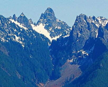
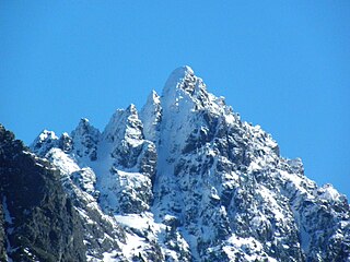
Magic Mountain is a 7,610-foot (2,320-metre) mountain summit located on the shared boundary of Skagit County and Chelan County in Washington state. It is part of the North Cascades Range, a subset of the Cascade Range. Magic Mountain is situated southeast of Cascade Pass on the shared border of North Cascades National Park and Glacier Peak Wilderness. The nearest peak is Pelton Peak 0.4 miles (0.64 km) to the northeast, and the nearest higher peak is Hurry-up Peak 0.83 miles (1.34 km) to the south. The Yawning Glacier and Cache Col Glacier rest on its northern flank. Magic Mountain is at the northern end of the Ptarmigan Traverse. Surface runoff on the north side the mountain drains into the Stehekin River, while precipitation drains into the Cascade River from the southwest side.

Mix-up Peak, also known as Mixup Peak, is a 7,440-foot (2,270-metre) mountain summit located on the shared boundary of Skagit County and Chelan County in Washington state. It is part of the North Cascades Range and is situated one mile south of Cascade Pass on the shared border of North Cascades National Park and Glacier Peak Wilderness. The nearest higher peak is Magic Mountain, 1.02 miles (1.64 km) to the east-southeast. Mix-up Peak is at the northern end of the Ptarmigan Traverse which is an alpine route to remote mountains such as Mount Formidable and Dome Peak. The Cache Glacier occupies a cirque below its eastern flank. Surface runoff on the east side the mountain drains into the Stehekin River, whereas precipitation runoff drains into the Cascade River from the west side.

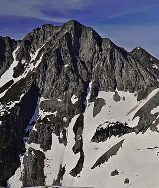
Repulse Peak is a 7,923-foot (2,415-metre) mountain summit in the North Cascades in the U.S. state of Washington. It is located on the border of the Stephen Mather Wilderness and North Cascades National Park. It's situated midway between Black Peak and Fisher Peak, and can be seen from the North Cascades Highway. Precipitation runoff from Repulse Peak drains into tributaries of the Skagit River and Stehekin River.
Sheep Mountain is a 6,166-foot-elevation (1,879-meter) summit near the western edge of the North Cascades, in Snohomish County of Washington state. It is located one mile east of Barlow Pass along the Mountain Loop Highway near the Monte Cristo area. It is situated on land administered by the Mount Baker-Snoqualmie National Forest. Back in the old mining days of the late 1800s, the long sub-range stretching from Cadet Peak to Sheep Mountain was known as Pride of the Mountains Range. Precipitation runoff from the mountain drains into tributaries of the Sauk River.

Crooked Bum is a 6,937-foot-elevation mountain summit on the crest of the North Cascades in the U.S. state of Washington. It is located in the Okanogan–Wenatchee National Forest on the shared border of Skagit County and Chelan County. It is situated immediately west of Rainy Pass and two miles east of Corteo Peak. The scenic and popular Maple Pass Trail traverses the south slope of the peak while staying above Lake Ann. Precipitation runoff from the north slope of Crooked Bum drains into Granite Creek which is a tributary of the Skagit River, whereas the south side drains into Bridge Creek which is a tributary of the Chelan River.
Big Snow Mountain is a prominent 6,680-foot (2,040-metre) mountain summit located 7 mi (11 km) north of Snoqualmie Pass in the Alpine Lakes Wilderness in eastern King County of Washington state. It is part of the Cascade Range and is situated on land managed by Mount Baker-Snoqualmie National Forest. Precipitation runoff from the mountain drains into tributaries of the Snoqualmie and Skykomish Rivers. The nearest higher peak is Overcoat Peak, 3.75 mi (6.04 km) to the east-southeast.
Merchant Peak is a 6,113-foot (1,863-metre) mountain summit located in Snohomish County, Washington. The mountain is part of the Cascade Range. Merchant Peak is the ninth highest point of the Wild Sky Wilderness. The nearest higher neighbor is Gunn Peak, 1.26 mi (2.03 km) to the northwest, and Baring Mountain lies 1.53 mi (2.46 km) to the south. Precipitation runoff from the mountain drains into tributaries of the Skykomish River. The peak was officially named in 1918 for Andrew Merchant, who made many mining claims around Trout Creek which is north of the peak.
Terrace Mountain is a 6,361-foot (1,939-metre) mountain summit located in the Alpine Lakes Wilderness in eastern King County of Washington state. It's part of the Cascade Range and is situated on land managed by Mount Baker-Snoqualmie National Forest. The peak is situated 4 mi (6.4 km) north of Mount Daniel, and is surrounded by Lake Clarice, Marmot Lake, Ptarmigan Lakes, and the Terrace Lakes. Precipitation runoff from the mountain drains into tributaries of the Skykomish River. The mountain's descriptive name stems from the terrace-like appearance created by a series of benches on its east aspect.

Tiffany Mountain is an 8,245-foot (2,513-metre) mountain summit located in Okanogan County in Washington state. It is the highest point in the Tiffany Range, which is a sub-range of the Okanogan Range. The mountain is situated on the east side of the Cascade crest, on land managed by the Okanogan–Wenatchee National Forest. The nearest higher peak is Windy Peak, 18 miles (29 km) to the north. Precipitation runoff from Tiffany Mountain drains into tributaries of the Columbia River.

Malachite Peak is a 6,261-foot (1,908-metre) mountain summit located 5.5 mi (8.9 km) south of Skykomish, in eastern King County of Washington state. It's part of the Cascade Range, and is situated one mile north of Lake Malachite in the Alpine Lakes Wilderness, on land managed by Mount Baker-Snoqualmie National Forest. Precipitation runoff from the mountain drains into tributaries of the Skykomish River. The nearest higher neighbor is Camp Robber Peak, 3.66 mi (5.89 km) to the south. The first ascent of this peak may have been in 1937 by a team from the United States Geological Survey. The USGS named the peak about 1975 based on a triangulation station marked as "Malachite".

Camp Robber Peak is a 6,286-foot (1,916-metre) mountain summit located above the western shore of Big Heart Lake, in eastern King County of Washington state. It's part of the Cascade Range, and is situated in the Alpine Lakes Wilderness, on land managed by Mount Baker-Snoqualmie National Forest. Precipitation runoff from the mountain drains into Camp Robber Creek and Foss River, both tributaries of the Skykomish River. This peak's name is derived from Camp Robber Creek and Camp Robber Lake, which lie in Camp Robber Valley to the northwest of the peak. "Camp robber" is the colloquial name for several North American species of birds known for their fearlessness around humans and their proclivity for stealing food from campers. The nearest higher neighbor is Wild Goat Peak, 1.3 mi (2.1 km) to the south.
Wild Goat Peak is a 6,305-foot (1,922-metre) mountain summit located above the eastern shore of Gold Lake, in eastern King County of Washington state. It's part of the Cascade Range, and is situated in the Alpine Lakes Wilderness, on land managed by Mount Baker-Snoqualmie National Forest. Precipitation runoff from the mountain drains into tributaries of the Snoqualmie and Skykomish Rivers. The nearest higher neighbor is Big Snow Mountain, 1.91 mi (3.07 km) to the southwest. This peak was once called "Big Snowy".

Surprise Mountain is a 6,330-foot (1,930-metre) mountain summit located above the southern end of Glacier Lake, in eastern King County of Washington state. It's part of the Wenatchee Mountains, which are a subset of the Cascade Range, and is situated in the Alpine Lakes Wilderness, on land managed by Mount Baker-Snoqualmie National Forest. Precipitation runoff from the mountain drains into Surprise Creek and Deception Creek, both tributaries of the Skykomish River. The nearest higher neighbor is Thunder Mountain, 0.88 mi (1.42 km) to the northeast, and Terrace Mountain is set 3 mi (4.8 km) to the southwest. The Pacific Crest Trail skirts this peak as it passes through Surprise Gap.

Spark Plug Mountain is a 6,320-foot (1,930-metre) mountain summit located above the western shore of Glacier Lake, in eastern King County of Washington state. It's part of the Wenatchee Mountains, which are a subset of the Cascade Range, and is situated in the Alpine Lakes Wilderness, on land managed by Mount Baker-Snoqualmie National Forest. The nearest higher neighbor is Surprise Mountain, 1.0 mi (1.6 km) to the southeast, and Thunder Mountain is set above the eastern shore of Glacier Lake. The Pacific Crest Trail skirts this lake as it passes between Spark Plug and Thunder. Spark Plug Lake, elevation 5,587-ft, lies immediately below the north aspect of the mountain, and Little Spark Plug is the 6,016-ft peak on the north side of this lake. Precipitation runoff from the mountain drains into Surprise Creek and Deception Creek, both tributaries of the Skykomish River.

Skykomish Peak is a 6,368-foot (1,941-metre) mountain summit located in the Henry M. Jackson Wilderness in the North Cascades of Washington state. The mountain is situated on the crest of the Cascade Range, on the shared border of Snohomish County with Chelan County, and also straddling the boundary between Mount Baker-Snoqualmie National Forest and Okanogan-Wenatchee National Forest. Skykomish Peak is located 15 mi (24 km) to the north of Stevens Pass, and the Pacific Crest Trail traverses the east slope of this peak. Precipitation runoff from the peak drains west into the Skykomish River, or east into Cady Creek which is a tributary of Little Wenatchee River. This mountain's name derives from its position at the head of the North Fork Skykomish River, and "Skykomish" comes from the Lushootseed word for the Skykomish people, sq̓ixʷəbš, meaning "upriver people".

Spire Mountain is a 6,213-foot (1,894-metre) Cascade Range mountain summit located in Snohomish County, Washington. It is set 7 miles (11 km) northeast of the town of Index, and 4 miles (6.4 km) north-northeast of Gunn Peak, its nearest higher neighbor. This mountain is situated in the Wild Sky Wilderness, on land managed by Mount Baker-Snoqualmie National Forest. Precipitation runoff from the mountain drains into tributaries of the Skykomish River. The first ascent of the highest Northwest Spire was made in 1934 by Dwight Dean and Kenneth Chapman. The first ascent of the Central Spire (6,200-ft) was made in 1938 by Karl Boyer, Lyman Boyer, and David Lind. The Southeast Spire is estimated as 6,185 feet in elevation.

Bald Eagle Peak is a 6,259-foot (1,908-metre) mountain summit located 7.4 mi (11.9 km) southeast of Skykomish, in eastern King County of Washington state. It's part of the Cascade Range, and is situated in the Alpine Lakes Wilderness, on land managed by Mount Baker-Snoqualmie National Forest. Precipitation runoff from this mountain drains into tributaries of the Foss River. This peak is set on the divide between the east and west forks of Foss River. The nearest neighbor is Silver Eagle Peak, 1.1 mi (1.8 km) to the southwest, and Bald Eagle Lake lies in a cirque midway between the pair. The first ascent of this peak was made in 1933 by Hermann Ulrichs and Ben Falkenburg via the North Ridge. This mountain's toponym and correct location was officially adopted September 8, 1988, by the U.S. Board on Geographic Names. Some older maps will have this peak erroneously labeled at Silver Eagle Peak's location.
Silver Eagle Peak is a 6,241-foot (1,902-metre) mountain summit located 7.7 mi (12.4 km) southeast of Skykomish, in eastern King County of Washington state. It's part of the Cascade Range, and is situated in the Alpine Lakes Wilderness, on land managed by Mount Baker-Snoqualmie National Forest. Precipitation runoff from this mountain drains into tributaries of the Foss River. This peak is set on the divide between the east and west forks of Foss River. Malachite Peak is set 2.6 mi (4.2 km) to the west-northwest, and the nearest higher neighbor is Bald Eagle Peak, 1.1 mi (1.8 km) to the northeast. Bald Eagle Lake lies in a cirque midway between Silver Eagle and Bald Eagle. The first ascent of this peak was made in 1934 by Hermann Ulrichs and three companions. This mountain's name was officially adopted September 8, 1988, by the U.S. Board on Geographic Names. Some older maps will have this peak erroneously labeled as Bald Eagle Peak.

Silvertip Peak is a 6,140-foot (1,870-metre) mountain summit located in the North Cascades, in Snohomish County of Washington state. It is situated 3.5 miles south of Barlow Pass along the Mountain Loop Highway, in the Henry M. Jackson Wilderness, on land managed by Mount Baker-Snoqualmie National Forest. Precipitation runoff from the mountain drains north into tributaries of the Sauk River, or south into headwaters of Silver Creek which is a tributary of Skykomish River. Neighbors surrounding Silvertip include Gothic Peak, Del Campo Peak, Sheep Mountain, Cadet Peak, and Columbia Peak. Silver Lake and Poodle Dog Pass lie on the east flank of Silvertip, the Monte Cristo mining ghost town sits at the northeast base, and the Mineral City ghost town is at the southern foot of this peak. This peak was named in association with the nearby Silver Tip mining claim.
Dip Top Peak is a 7,291-foot-elevation mountain summit located in the Alpine Lakes Wilderness in eastern King County of Washington state. It is part of the Cascade Range and is set on land managed by Mount Baker-Snoqualmie National Forest. The peak is situated 1.25 mi (2.01 km) north of Mount Daniel, and less than one mile south of Jade Lake. Precipitation runoff from the mountain drains into East Fork Foss River, which is a tributary of the Skykomish River. The summit saddle has two rock horns, of which the higher southwest peak is the true summit. The first ascent was made August 1950 by Bill and Gene Prater. In the early 1970s, brothers Gene and Bill Prater created the modern aluminum snowshoe known today, and sold them via Bill's "Sherpa Snowshoes" company, which proved very popular.