Related Research Articles

The San Juan Islands is an archipelago in the Pacific Northwest of the United States between the U.S. state of Washington and Vancouver Island, British Columbia, Canada. The San Juan Islands are part of Washington state, and form the core of San Juan County.

Whatcom County is a county located in the northwestern corner of the U.S. state of Washington, bordered by the Lower Mainland of British Columbia to the north, Okanogan County to the east, Skagit County to the south, San Juan County across Rosario Strait to the southwest, and the Strait of Georgia to the west. Its county seat and largest population center is the coastal city of Bellingham, comprising the Bellingham, WA Metropolitan Statistical Area, and as of the 2020 census, the county's population was 226,847.

The Pig War was a confrontation in 1859 between the United States and the United Kingdom over the British–U.S. border in the San Juan Islands, between Vancouver Island and the State of Washington. The Pig War, so called because it was triggered by the shooting of a pig, is also called the Pig Episode, the Pig and Potato War, the San Juan Boundary Dispute, and the Northwestern Boundary Dispute. Despite being referred to as a "war", there were no casualties on either side.

Orcas Island is the largest of the San Juan Islands of the Pacific Northwest, in northwestern Washington, United States.

Shaw Island is the smallest of the four San Juan Islands served by the Washington State Ferries. The island has a land area of 19.952 square kilometers and a small year-round population of 188. During the summer time, weekends swell with other residents and the occasional tourist.

Sucia Island is located 2.5 miles (4.0 km) north of Orcas Island in the San Juan Islands, San Juan County, Washington, United States. It is the largest of an archipelago of ten islands including Sucia Island, Little Sucia, Ewing, Justice, Herndon, the Cluster Islands islets, and several smaller, unnamed islands. The group of islands is about 2.5 miles (4.0 km) in length and just short of a half mile wide. Sucia island is roughly the shape of a hand. The total land area of all islands is 2.74 km2. The main island of Sucia Island by itself is 2.259 km2. There was a permanent population of four persons as of the 2000 census, all on Sucia Island. Sucia Island State Park is a Washington State Marine Park.

San Juan Island National Historical Park, also known as American and English Camps, San Juan Island, is a U.S. National Historical Park owned and operated by the National Park Service on San Juan Island in the state of Washington. The park is made up of the sites of the British and U.S. Army camps during the Pig War, a boundary dispute over the ownership of the island. The camp sites were designated a National Historic Landmark in 1961, and listed on the National Register of Historic Places in 1966. The park was created by an act of Congress in 1966 and expanded slightly in 2013.

Eastsound is an unincorporated community on Orcas Island in San Juan County, Washington, United States.

Discovery Island Marine Provincial Park is a provincial park located about two nautical miles east of Oak Bay on the coast of British Columbia, Canada. It is about one mile (1.6 km) long and one-half mile (0.80 km) wide and looks out into the Strait of Juan de Fuca.
Saanich Peninsula is located north of Victoria, British Columbia, Canada. It is bounded by Saanich Inlet on the west, Satellite Channel on the north, the small Colburne Passage on the northeast, and Haro Strait on the east. The exact southern boundary of what is referred to as the "Saanich Peninsula" is somewhat fluid in local parlance.

Manuel Quimper Benítez del Pino was a Spanish Peruvian explorer, cartographer, naval officer, and colonial official. He participated in charting the Strait of Juan de Fuca and the Sandwich Islands in the late 18th century. He was later appointed a colonial governor in his native Peru at the beginning of the fight for independence there. He retired to Spain, but was able to return to Peru where he served as a naval officer in the new republic and pursued a literary career, publishing over 20 books about his experiences before his death there in Lima.
Vendovi Island is an island in the San Juan Islands of Washington State. Located in Skagit County, Washington, United States, Vendovi Island lies across Samish Bay from mainland Skagit County, between Guemes Island and Lummi Island. Vendovi Island has a land area of 220.24 acres (89.13 ha) and a population of two persons was reported as of the 2000 census. The Island was named after a Fijian High Chief Ro Veidovi who was brought to North America by the Wilkes Expedition.

Skull Island is the name of two small islands in the San Juan Archipelago in the U.S. state of Washington. The northernmost Skull Island is located off the coast of Orcas Island in Massacre Bay, the most northern extension of the island's West Sound. It is identified as 3.2-acre (1.3 ha) Skull Island State Park Property by the Washington State Parks and Recreation Commission. It was named for holding skulls and bones of a band of Lummi who were killed by raiding Haida in 1858. Since 2013, it has been part of the San Juan Islands National Monument.
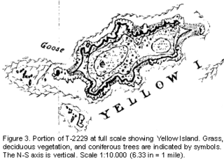
Yellow Island, one of the San Juan Islands, is an 11-acre (4.5 ha) island, located south-west of Orcas Island, and north of Shaw Island, near Jones Island State Park, in San Juan County, Washington, United States. The island is home to a wide array of flora and fauna, including over 50 species of wildflowers, bald eagles, harbor seals, black oystercatchers, and harlequin ducks. The island was purchased in 1979 by The Nature Conservancy, and is administered as a nature preserve.

Matia Island is an island in the San Juan Islands of the U.S. state of Washington. The island's entire 145 acres (59 ha) comes under the protection of the U.S. Fish and Wildlife Service and is cooperatively managed by the Washington State Parks and Recreation Commission as Matia Island Marine State Park. Matia Island is a National Wildlife Refuge, part of the San Juan Islands National Wildlife Refuge. A 2-acre (0.81 ha) camping area around Rolfe Cove is managed as a State Marine Park by the Washington State Parks and Recreation Commission under an agreement dating back to 1959. Pets, wood collecting, and campfires are not allowed on the island. Except for the Wilderness Loop Trail and the campground, all areas above the high tide line are closed to the public.
Dinner Island is an island in the San Juan Islands of the U.S. state of Washington. It lies in Griffin Bay on the southeastern coast of San Juan Island.

Roche Harbor is a sheltered harbor on the northwest side of San Juan Island in San Juan County, Washington, United States, and the site of a resort of the same name. Roche Harbor faces Haro Strait and the Canada–United States border. The harbor itself provides one of the better protected anchorages in the islands. The harbor is surrounded on the east side by San Juan Island, on the north side by Pearl Island, and on the west and south sides by Henry Island. Most of the harbor is 35 to 45 feet deep. Roche Harbor has a small airport used primarily by local residents.

The Mitchell Bay Band of the San Juan Islands is an indigenous Coast Salish community based in the San Juan Islands of Washington, United States. The community was first referred to as the Mitchell Bay Tribe by Office of Indian Affairs agent Charles Roblin in his 1919 Census of Unenrolled Indians, in reference to one of several bays with historically significant indigenous populations.
References
- ↑ Phillips, James W. (1971). Washington State Place Names. University of Washington Press. ISBN 0-295-95158-3.
48°35′5″N123°9′14.8″W / 48.58472°N 123.154111°W
| | This San Juan County, Washington state location article is a stub. You can help Wikipedia by expanding it. |