The NP postcode area, also known as the Newport postcode area, is a group of eighteen postcode districts, which are subdivisions of fourteen post towns. These cover south-east Wales, including Newport, Pontypool, Abergavenny, Monmouth, Chepstow, Abertillery, Usk, Tredegar, New Tredegar, Ebbw Vale, Crickhowell, Blackwood, Caldicot and Cwmbran, plus a small part of the English counties of Gloucestershire and Herefordshire.
The DE postcode area, also known as the Derby postcode area, is a group of 23 postcode districts in central England, within 11 post towns. These cover south and central Derbyshire, parts of east Staffordshire and north-west Leicestershire, and very small parts of Nottinghamshire.
The HP postcode area, also known as the Hemel Hempstead postcode area, is a group of twenty-four postcode districts in England, within eleven post towns. These cover north-west Hertfordshire and central Buckinghamshire.
The LN postcode area, also known as the Lincoln postcode area, is a group of thirteen postcode districts in eastern England, within seven post towns. These cover central Lincolnshire, including Lincoln, Alford, Horncastle, Louth, Mablethorpe, Market Rasen and Woodhall Spa.
The LU postcode area, also known as the Luton postcode area, is a group of seven postcode districts in England, within three post towns. These cover south Bedfordshire, plus small parts of north Hertfordshire and east Buckinghamshire.
The MK postcode area, also known as the Milton Keynes postcode area, is a group of 26 postcode districts in England, within five post towns. These cover north Buckinghamshire, west and north Bedfordshire and very small parts of Northamptonshire, Oxfordshire and Cambridgeshire.
The YO postcode area, also known as the York postcode area, is a group of 29 postcode districts in Yorkshire, England, within ten post towns. These cover most of Central and Eastern North Yorkshire and the northern part of the East Riding of Yorkshire. The rest of North Yorkshire is split between the TS, DL, LA, BD, HG, DN and WF postcode areas.
The NN postcode area, also known as the Northampton postcode area, is a group of nineteen postcode districts in England, within eight post towns. These cover most of Northamptonshire, plus very small parts of Bedfordshire, Buckinghamshire, Leicestershire, Oxfordshire and Warwickshire.
The LS postcode area, also known as the Leeds postcode area, is a group of 29 postcode districts in England, within six post towns. These cover northern West Yorkshire and some parts of North Yorkshire.
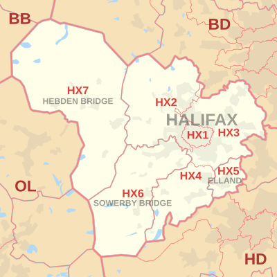
The BD postcode area, also known as the Bradford postcode area, is a group of 24 postcode districts in England, within seven post towns. These cover northwestern West Yorkshire and southwestern North Yorkshire, plus very small parts of Lancashire.
The LL postcode area, also known as the Llandudno postcode area, is a group of 67 postcode districts, within 62 post towns. These cover the majority of north Wales, plus a very small part of west Wales and the English county of Shropshire. The districts start at LL11 so as to avoid confusion with Liverpool postcodes.
The SP postcode area, also known as the Salisbury postcode area, is a group of eleven postcode districts in southern England, within six post towns. These cover south Wiltshire and parts of north Dorset and west Hampshire.
The ST postcode area, also known as the Stoke-on-Trent postcode area, is a group of 21 postcode districts in England, within six post towns. These cover much of north and central Staffordshire, plus very small parts of Cheshire and Derbyshire.
The IV postcode area, also known as the Inverness postcode area, is a group of 52 postcode districts for post towns: Achnasheen, Alness, Avoch, Beauly, Bonar Bridge, Cromarty, Dingwall, Dornoch, Elgin, Fochabers, Forres, Fortrose, Gairloch, Garve, Invergordon, Inverness, Isle of Skye, Kyle, Lairg, Lossiemouth, Muir of Ord, Munlochy, Nairn, Plockton, Portree, Rogart, Strathcarron, Strathpeffer, Strome Ferry, Tain and Ullapool in north Scotland.
The PH postcode area, also known as the Perth postcode area, is a group of 43 postcode districts for post towns: Aberfeldy, Acharacle, Arisaig, Auchterarder, Aviemore, Ballachulish, Blairgowrie, Boat of Garten, Carrbridge, Corrour, Crieff, Dalwhinnie, Dunkeld, Fort Augustus, Fort William, Glenfinnan, Grantown-on-Spey, Invergarry, Isle of Canna, Isle of Eigg, Isle of Rum, Kingussie, Kinlochleven, Lochailort, Mallaig, Nethy Bridge, Newtonmore, Perth, Pitlochry, Roy Bridge and Spean Bridge in Scotland.
The PA postcode area, also known as the Paisley postcode area, is a group of 67 postcode districts in western Scotland, within 35 post towns. These cover Renfrewshire, Inverclyde and most of Argyll and Bute, plus small parts of North Ayrshire and Highland.
The CT postcode area, also known as the Canterbury postcode area, is a group of 21 postcode districts in South East England, within 13 post towns. These cover much of east Kent, including Canterbury, Dover, Folkestone, Birchington, Broadstairs, Deal, Herne Bay, Hythe, Margate, Ramsgate, Sandwich, Westgate-on-Sea and Whitstable.
The TF postcode area, also known as the Telford postcode area, is a group of thirteen postcode districts in England, within six post towns. These cover north-east Shropshire, including Telford, Broseley, Market Drayton, Much Wenlock, Newport and Shifnal, plus a small part of west Staffordshire.
The HR postcode area, also known as the Hereford postcode area, is a group of nine postcode districts in England and Wales, within six post towns. These cover most of Herefordshire, including Hereford, Bromyard, Kington, Ledbury, Leominster and Ross-on-Wye. The area also covers very small parts of Gloucestershire and Worcestershire, while the HR2, HR3 and HR5 districts extend across the border to cover a small part of Powys.
The HS postcode area, also known as the Outer Hebrides postcode area, is a group of nine postcode districts, within eight post towns, covering the Outer Hebrides in Scotland.