Hale City, Texas

Last updated

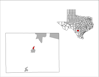
Hale City is a ghost town in central Hale County, Texas, United States. It was located northwest of Hale Center, a city near Plainview, Texas, and was merged with Epworth in 1891 to form Hale Center.[ citation needed ]

Ghost town City depopulated of inhabitants and that stays practically intact

A ghost town or alternatively deserted city or abandoned city is an abandoned village, town, or city, usually one that contains substantial visible remaining buildings and infrastructure such as roads. A town often becomes a ghost town because the economic activity that supported it has failed, or due to natural or human-caused disasters such as floods, prolonged droughts, government actions, uncontrolled lawlessness, war, pollution, or nuclear disasters. The term can sometimes refer to cities, towns, and neighborhoods that are still populated, but significantly less so than in past years; for example, those affected by high levels of unemployment and dereliction.

Hale County, Texas U.S. county in Texas

Hale County is a county located in the U.S. state of Texas. As of the 2010 census, its population was 36,273. The county seat is Plainview. The county was created in 1876 and organized in 1888. It is named for Lt. John C. Hale, a hero of the Battle of San Jacinto. Hale County comprises the Plainview, Texas micropolitan statistical area.

Texas State in the United States

Texas is the second largest state in the United States by area and population. Located in the South Central region, Texas shares borders with the states of Louisiana to the east, Arkansas to the northeast, Oklahoma to the north, New Mexico to the west, and the Mexican states of Chihuahua, Coahuila, Nuevo León, and Tamaulipas to the southwest, and has a coastline with the Gulf of Mexico to the southeast.

Coordinates: 34°05′34″N101°52′20″W / 34.09278°N 101.87222°W / 34.09278; -101.87222

Geographic coordinate system Coordinate system

A geographic coordinate system is a coordinate system that enables every location on Earth to be specified by a set of numbers, letters or symbols. The coordinates are often chosen such that one of the numbers represents a vertical position and two or three of the numbers represent a horizontal position; alternatively, a geographic position may be expressed in a combined three-dimensional Cartesian vector. A common choice of coordinates is latitude, longitude and elevation. To specify a location on a plane requires a map projection.


Related Research Articles

Crosbyton, Texas City in Texas, United States

Crosbyton is a city in and the county seat of Crosby County, Texas, United States. The population was 1,741 at the 2010 census. Crosbyton is part of the Lubbock Metropolitan Statistical Area.

North Pearsall, Texas Census-designated place in Texas, United States

North Pearsall is a census-designated place (CDP) in Frio County, Texas, United States. The population was 614 at the 2010 census.

Hale Center, Texas City in Texas, United States

Hale Center is a city in Hale County, Texas. The population was 2,252 at the 2010 census.

Petersburg, Texas City in Texas, United States

Petersburg is a city in Hale County, Texas, United States. As of the 2010 census it had a population of 1,202.

Paita Province Province in Piura, Peru

The Paita Province is one of eight provinces of the Piura Region in northwestern Peru.

Bethany is a neighborhood of Louisville, Kentucky located on Dixie Highway by Bethany Cemetery.

KBTE

KBTE,, known as "104.9 The Beat", is an Urban Contemporary formatted radio station owned by Alpha Media of Lubbock, Texas. Their city of license is Tulia, Texas and serves the Lubbock area with an ERP of 96,600 Watts. Its studios are located in south Lubbock on Avenue Q west of I-27, and its transmitter is located southeast of Plainview, Texas in unincorporated Hale County.

Chester Township, Logan County, Illinois Township in Illinois, United States

Chester Township is located in Logan County, Illinois. As of the 2010 census, its population was 669 and it contained 298 housing units. Chester Township changed its name from Madison Township sometime prior to 1921.

La Misión, Baja California Place in Baja California, Mexico

La Misión or Misión de San Miguel is a village in Baja California located on Mexican Federal Highway 1 approximately 41 miles south of the San Ysidro border crossing on the Gold Coast of the Baja California peninsula. The census of 2010 reported a population of 920 inhabitants. The small town of Primo Tapia, located 15 km north, is the closest town to La Misión. Puerto Nuevo, known for their lobster restaurants, is 20 km north of the village. La Mision is so small, it's often simply referred to as "K-44" or "kilometro 44", which is its nearest highway marker. The port city of Ensenada is 50 km south of La Misión while the town of Rosarito is 40 km north.

Yunguyo Province Province in Puno, Peru

Yunguyo Province is a province of the Puno Region in Peru. The capital of the province is the city of Yunguyo.

Campestre da Serra is a municipality in the southern state Rio Grande do Sul, Brazil. It's 2526 feet above sea level.

City Park, New Orleans New Orleans Neighborhood in Louisiana, United States

City Park is a neighborhood of the city of New Orleans, USA. A subdistrict of the Lakeview District Area, its boundaries as defined by the City Planning Commission are: Robert E. Lee Boulevard to the north, Bayou St. John to the east, Orleans Avenue, North Carrollton Avenue and Toulouse Street to the south and City Park and Orleans Avenues to the west. The neighborhood is named after and dominated by City Park.

Goudomp Department Department in Sédhiou Region, Senegal

Goudomp Department is one of the 45 departments of Senegal, one of three making up the Sédhiou Region. It was created in 2008 along with the Sédhiou Region, which was formerly part of the Kolda Region.

Hallsville, Illinois Unincorporated community in Illinois, United States

Hallsville is an unincorporated community in Barnett Township, DeWitt County, Illinois, United States.

Munder, Suriname Resort in Paramaribo District, Suriname

Munder is a resort in Suriname, in the Paramaribo District. Its population at the 2012 census was 17,234.

Nadhour is a town and commune in the Zaghouan Governorate, Tunisia. As of 2004 it had a population of 5,207.

China Hill is an unincorporated community in Richmond County, in the U.S. state of Virginia.

Forrester is an unincorporated community in Le Flore County, Oklahoma, in the United States.

Balaton (village) Village in Northern Hungary, Hungary

Balaton is a village in Heves County, Northern Hungary Region, Hungary.