
Hammersley Inlet, in southwestern Puget Sound in the U.S. state of Washington, is an arm of water opening north of Arcadia and leading to the city of Shelton and Oakland Bay. Hammersley Inlet is also known as Big Skookum. [1]
Hammersley Inlet, in southwestern Puget Sound in the U.S. state of Washington, is an arm of water opening north of Arcadia and leading to the city of Shelton and Oakland Bay. Hammersley Inlet is also known as Big Skookum. [1]
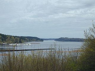
Hammersley Inlet connects the Oakland Bay and Shelton to the greater Puget Sound. It is approximately 8 nautical miles (15 km) of winding, potentially rapidly flowing water. As tides change in the South Puget Sound, Hammersley Inlet is the only artery through which all water must flow between the Oakland Bay and the greater Puget Sound. As tides change, they force the water through narrow, winding, shallow, Hammersley, producing erratic currents up to 5 knots (9 km/h). Many mariners avoid Hammersley because of these conditions, but with the proper planning, a depth sounder, and care, Hammersley can be navigated without incident. The NOAA chart for the inlet is #18457, but most locals rely on the placemats from the Shelton Yacht Club. [2]
There are few aids to navigation on Hammersley, as the many log booms towed through the inlet over the years have destroyed them. Mariners are advised to study their charts, create a route, and stick to it. Hammersley Inlet ends as it meets the Oakland Bay, in the city of Shelton. Hammersley Inlet is also known for its abundant shellfish production of clams and oysters.
Hammersley Inlet was named - and misspelled - by Charles Wilkes during the Wilkes Expedition of 1838–1842, to honor George W. Hammersly, one of the expedition's midshipmen. [3]

Puget Sound is a sound of the Pacific Northwest, an inlet of the Pacific Ocean, and part of the Salish Sea. It is located along the northwestern coast of the U.S. state of Washington. It is a complex estuarine system of interconnected marine waterways and basins, with one major and two minor connections to the open Pacific Ocean via the Strait of Juan de Fuca—Admiralty Inlet being the major connection and Deception Pass and Swinomish Channel being the minor.

The San Juan Islands is an archipelago in the Pacific Northwest of the United States between the U.S. state of Washington and Vancouver Island, British Columbia, Canada. The San Juan Islands are part of Washington state, and form the core of San Juan County.

Mason County is a county located in the U.S. state of Washington. As of the 2020 census, the population was 65,726. The county seat and only incorporated city is Shelton. The county was formed out of Thurston County on March 13, 1854. Originally named Sawamish County, it took its present name in 1864 in honor of Charles H. Mason, the first Secretary of Washington Territory.
Raft Island is a private island and CDP located near the Pierce County community of Rosedale, Washington, United States. Gig Harbor, Washington is the nearest incorporated town, although unincorporated Artondale is much closer. The island features approximately 200 homes on 160 acres. All of these homes are served through the Gig Harbor post office.

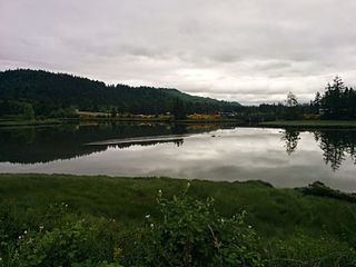
Oakland Bay is a tidal estuarial body of water near the town of Shelton, Washington. It is connected to the larger Puget Sound via Hammersley Inlet. The community of Bay Shore, Washington was located on Oakland Bay. The major freshwater inlet is Goldsborough Creek, which runs through the town of Shelton.
Stretch Island is an island in Case Inlet in the southern part of Puget Sound in the U.S. state of Washington. It forms part of the unincorporated Mason County community of Allyn-Grapeview. The island has a land area of 1.2179 km2 and a population of 162 persons as of the 2010 census. On the island's north side, it has buoys for overnight mooring, and Stretch Point State Park, a small state park only accessible by boat.
Herron Island is an island in central Case Inlet in the southern part of Puget Sound in the U.S. state of Washington. The Pierce County island has a land area of 1.2326 km² and a population of 151 persons as of the 2010 census.

Quartermaster Harbor is a small harbor located in southern Puget Sound, in Vashon Island, Washington state.


Totten Inlet lies in the southern end of Puget Sound in the U.S. state of Washington. The inlet extends 9 miles (14 km) southwest from the western end of Squaxin Passage, and much of the county line between Mason and Thurston counties runs down the center of it. A spit extends west for about 300 feet (91 m) from Steamboat Island. The inlet shoals gradually to near Burns Point, 100 feet high, on the south shore, where it bares at low tide.
Carr Inlet, in southern Puget Sound in the U.S. state of Washington, is an arm of water between Key Peninsula and Gig Harbor Peninsula. Its southern end is connected to the southern basin of Puget Sound. Northward, it separates McNeil Island and Fox Island. The northern end of Carr Inlet is named Henderson Bay, which feeds into Burley Lagoon.
Case Inlet, in southern Puget Sound in the U.S. state of Washington, is an arm of water between Key Peninsula to the east and Harstine Island to the west. Its northern end, called North Bay, reaches nearly to Hood Canal, creating the defining isthmus of Kitsap Peninsula. Case Inlet is the boundary between Pierce County and Mason County. The southern end of Case Inlet connects to Nisqually Reach, part of the southern basin of Puget Sound. Herron Island lies in Case Inlet.
Eld Inlet is an inlet located at the southern end of Puget Sound in Thurston County, Washington. It is the second southernmost arm of Puget Sound after neighboring Budd Inlet.
Bay Shore, Washington was a small community located on Oakland Bay in southern Puget Sound, not far away from the present city of Shelton, Washington.
Agate is a small community in the state of Washington, United States. It is located on southern Puget Sound on the north side of the entrance to Hammersley Inlet.
Oyster Bay is an inlet in southern Puget Sound which branches off from Totten Inlet. The bay spans Mason and Thurston counties, in the U.S. state of Washington. Kennedy Creek empties into the bay at the U.S. Highway 101 overpass.
Arcadia, Washington is an unincorporated community in Mason County, Washington, which is located on southwest Puget Sound on a point of land which extends between Hammersley Inlet on the north and Totten Inlet on the south. It is situated between Olympia, Washington and Shelton, Washington.
Mud Bay is the southernmost reach of Puget Sound, at Eld Inlet just outside the city limits of Olympia, Washington. The name Eld Inlet was officially bestowed after a member of the U.S. Navy's Wilkes Expedition, but "Mud Bay" is a local, informal adoption.

South Puget Sound is the southern reaches of Puget Sound in Southwest Washington, in the United States' Pacific Northwest. It is one of five major basins encompassing the entire Sound, and the shallowest basin, with a mean depth of 37 meters (121 ft). Exact definitions of the region vary: the state's Department of Fish and Wildlife counts all of Puget Sound south of the Tacoma Narrows for fishing regulatory purposes. The same agency counts Mason, Jefferson, Kitsap, Pierce and Thurston Counties for wildlife management. The state's Department of Ecology defines a similar area south of Colvos Passage.
| International | |
|---|---|
| Other | |
47°12′20″N123°01′01″W / 47.20556°N 123.01694°W
| | This Mason County, Washington state location article is a stub. You can help Wikipedia by expanding it. |