Mason County, Washington

Last updated

Mason County
Mason County Courthouse - Shelton Washington.jpg
Mason County Courthouse
Masonlogo.png
Map of Washington highlighting Mason County.svg
Location within the U.S. state of Washington
Washington in United States.svg
Washington's location within the U.S.
Coordinates: 47°21′N123°11′W / 47.35°N 123.18°W / 47.35; -123.18
CountryFlag of the United States.svg United States
StateFlag of Washington.svg  Washington
FoundedMarch 13, 1854
Named for Charles H. Mason
Seat Shelton
Largest cityShelton
Area
  Total1,051 sq mi (2,720 km2)
  Land959 sq mi (2,480 km2)
  Water92 sq mi (240 km2)  8.7%
Population
 (2020)
  Total65,726
  Estimate 
(2022)
68,166 Increase2.svg
  Density63/sq mi (24/km2)
Time zone UTC−8 (Pacific)
  Summer (DST) UTC−7 (PDT)
Congressional district 6th
Website www.masoncountywa.gov

Mason County is a county located in the U.S. state of Washington. As of the 2020 census, the population was 65,726. [1] The county seat and only incorporated city is Shelton. [2] The county was formed out of Thurston County on March 13, 1854. [3] Originally named Sawamish County, it took its present name in 1864 in honor of Charles H. Mason, the first Secretary of Washington Territory. [3] [4]

Contents

Mason County comprises the Shelton, WA Micropolitan Statistical Area and is included in the Seattle-Tacoma, WA Combined Statistical Area.

Peak of Mount Ellinor in the Olympic Mountains of Mason County Mount Ellinor, Mount Washington Panorama.jpg
Peak of Mount Ellinor in the Olympic Mountains of Mason County

Geography

Mount Rainier over the Totten Inlet. Mason County, Washington. Mount Rainier over Totten Inlet.jpg
Mount Rainier over the Totten Inlet. Mason County, Washington.

According to the United States Census Bureau, the county has a total area of 1,051 square miles (2,720 km2), of which 959 square miles (2,480 km2) is land and 92 square miles (240 km2) (8.7%) is water. [5]

Geographic features

Oakland Bay

Major highways

Adjacent counties

National protected areas

Demographics

Historical population
CensusPop.Note
1860 162
1870 28978.4%
1880 639121.1%
1890 2,826342.3%
1900 3,81034.8%
1910 5,15635.3%
1920 4,919−4.6%
1930 10,060104.5%
1940 11,60315.3%
1950 15,02229.5%
1960 16,2518.2%
1970 20,91828.7%
1980 31,18449.1%
1990 38,34123.0%
2000 49,40528.9%
2010 60,69922.9%
2020 65,7268.3%
2022 (est.)68,166 [6] 3.7%
U.S. Decennial Census [7]
1790–1960 [8] 1900–1990 [9]
1990–2000 [10] 2010–2020 [1]

2000 census

As of the 2000 census, there were 49,405 people, 18,912 households, and 13,389 families living in the county. The population density was 51 people per square mile (20 people/km2). There were 25,515 housing units at an average density of 26 units per square mile (10 units/km2). The racial makeup of the county was 88.46% White, 1.19% Black or African American, 3.72% Native American, 1.05% Asian, 0.45% Pacific Islander, 2.10% from other races, and 3.03% from two or more races. 4.78% of the population were Hispanic or Latino of any race. 16.7% were of German, 9.9% Irish, 9.8% English, 8.6% United States or American and 6.8% Norwegian ancestry.

There were 18,912 households, out of which 28.90% had children under the age of 18 living with them, 56.90% were married couples living together, 9.20% had a female householder with no husband present, and 29.20% were non-families. 23.30% of all households were made up of individuals, and 9.90% had someone living alone who was 65 years of age or older. The average household size was 2.49 and the average family size was 2.89.

In the county, the population was spread out, with 23.50% under the age of 18, 7.70% from 18 to 24, 26.50% from 25 to 44, 25.80% from 45 to 64, and 16.50% who were 65 years of age or older. The median age was 40 years. For every 100 females there were 107.00 males. For every 100 females age 18 and over, there were 107.30 males.

The median income for a household in the county was $39,586, and the median income for a family was $44,246. Males had a median income of $37,007 versus $25,817 for females. The per capita income for the county was $18,056. About 8.80% of families and 12.20% of the population were below the poverty line, including 17.30% of those under age 18 and 4.90% of those age 65 or over.

2010 census

As of the 2010 census, there were 60,699 people, 23,832 households, and 16,057 families living in the county. [11] The population density was 63.3 inhabitants per square mile (24.4/km2). There were 32,518 housing units at an average density of 33.9 units per square mile (13.1 units/km2). [12] The racial makeup of the county was 86.1% white, 3.7% American Indian, 1.2% Asian, 1.1% black or African American, 0.4% Pacific islander, 3.4% from other races, and 4.1% from two or more races. Those of Hispanic or Latino origin made up 8.0% of the population. [11] In terms of ancestry, 19.7% were German, 13.8% were English, 13.5% were Irish, 6.7% were Norwegian, and 4.9% were American. [13]

Of the 23,832 households, 27.0% had children under the age of 18 living with them, 52.5% were married couples living together, 9.5% had a female householder with no husband present, 32.6% were non-families, and 25.3% of all households were made up of individuals. The average household size was 2.45 and the average family size was 2.87. The median age was 44.4 years. [11]

The median income for a household in the county was $48,104 and the median income for a family was $56,809. Males had a median income of $44,992 versus $33,982 for females. The per capita income for the county was $22,530. About 11.1% of families and 15.6% of the population were below the poverty line, including 21.0% of those under age 18 and 9.0% of those age 65 or over. [14]

Communities

City

Census-designated places

Unincorporated communities

Politics

Government

Board of County Commissioners

State Legislators

35th Legislative District

United States presidential election results for Mason County, Washington [18] [19]
Year Republican Democratic Third party
No.%No.%No.%
2020 18,71050.16%17,26946.29%1,3243.55%
2016 13,67747.16%11,99341.35%3,33311.49%
2012 12,76144.79%14,76451.82%9643.38%
2008 12,60044.19%15,05052.78%8633.03%
2004 11,98747.20%12,89450.78%5132.02%
2000 10,25745.63%10,87648.38%1,3475.99%
1996 7,14934.45%10,08848.62%3,51316.93%
1992 5,77629.43%8,07641.15%5,77429.42%
1988 7,42647.77%7,82650.34%2931.88%
1984 8,41053.74%7,00744.77%2331.49%
1980 6,74549.10%5,24138.15%1,75112.75%
1976 4,75842.14%6,06053.67%4734.19%
1972 4,87353.10%3,90742.57%3974.33%
1968 3,39739.55%4,54052.85%6537.60%
1964 2,54931.58%5,51468.32%80.10%
1960 3,70346.86%4,18352.94%160.20%
1956 4,02651.05%3,84048.69%200.25%
1952 3,82749.70%3,83049.74%430.56%
1948 2,52438.82%3,61355.58%3645.60%
1944 1,97636.61%3,37962.61%420.78%
1940 1,77533.20%3,46564.81%1061.98%
1936 1,01523.08%3,08770.19%2966.73%
1932 99525.50%2,18155.89%72618.61%
1928 1,74562.95%99235.79%351.26%
1924 90249.02%1799.73%75941.25%
1920 99756.04%38321.53%39922.43%
1916 76444.32%77945.19%18110.50%
1912 43924.42%52229.03%83746.55%
1908 55356.60%31832.55%10610.85%
1904 66163.50%31530.26%656.24%
1900 51451.40%45545.50%313.10%
1896 39736.86%66761.93%131.21%
1892 35242.00%35642.48%13015.51%

Healthcare

Mason County has one hospital, Mason General Hospital, in Shelton, operated by Washington Public Hospital District No. 1. [20] [21] [22]

See also

Related Research Articles

<span class="mw-page-title-main">Nez Perce County, Idaho</span> County in Idaho, United States

Nez Perce County is a county located in the U.S. state of Idaho. As of the 2020 census, the population was 42,090. The county seat is Lewiston. The county is named after the Native American Nez Perce tribe. Nez Perce County is part of the Lewiston, Idaho–WA Metropolitan Statistical Area.

<span class="mw-page-title-main">Braxton County, West Virginia</span> County in West Virginia, United States

Braxton County is a county in the central part of the U.S. state of West Virginia. As of the 2020 census, the population was 12,447. The county seat is Sutton. The county was formed in 1836 from parts of Lewis, Kanawha, and Nicholas counties and named for Carter Braxton, a Virginia statesman and signer of the Declaration of Independence.

<span class="mw-page-title-main">Wood County, West Virginia</span> County in West Virginia, United States

Wood County is a county in the U.S. state of West Virginia. As of the 2020 census, the population was 84,296, making it West Virginia's fifth-most populous county. Its county seat is Parkersburg. The county was formed in 1798 from the western part of Harrison County and named for James Wood, governor of Virginia from 1796 to 1799.

<span class="mw-page-title-main">Pleasants County, West Virginia</span> County in West Virginia, United States

Pleasants County is a county located in the U.S. state of West Virginia. At the 2020 census, the population was 7,653. Its county seat is St. Marys.

<span class="mw-page-title-main">Pacific County, Washington</span> County in Washington, United States

Pacific County is a county in the U.S. state of Washington. As of the 2020 census, the population was 23,365. Its county seat is South Bend, and its largest city is Raymond. The county was formed by the government of Oregon Territory in February 1851 and is named for the Pacific Ocean.

<span class="mw-page-title-main">Klickitat County, Washington</span> County in Washington, United States

Klickitat County is a county located in the U.S. state of Washington. As of the 2020 census, the population was 22,735. The county seat and largest city is Goldendale. The county is named after the Klickitat tribe.

<span class="mw-page-title-main">Jefferson County, Washington</span> County in Washington, United States

Jefferson County is a county located in the U.S. state of Washington. As of the 2020 census, the population was 32,977. The county seat and only incorporated city is Port Townsend. The county is named for Thomas Jefferson.

<span class="mw-page-title-main">Garfield County, Washington</span> County in Washington, United States

Garfield County is a county located in the U.S. state of Washington. As of the 2020 census, the population was 2,286, making it the least populous county in Washington; with about 3.2 inhabitants per square mile (1.2/km2), it is also the least densely populated county in Washington. The county seat and only city is Pomeroy.

<span class="mw-page-title-main">Perry County, Ohio</span> County in Ohio, United States

Perry County is a county located in the U.S. state of Ohio. As of the 2020 census, the population was 35,408. Its county seat is New Lexington. It was established on March 1, 1818, from parts of Fairfield, Washington and Muskingum counties. The county is named for Oliver Hazard Perry, a hero of the War of 1812. Perry County is included in the Columbus, OH Metropolitan Statistical Area. One of the poorest counties in the state, this is where the lawsuit challenging Ohio's school funding system, DeRolph v. State, began.

<span class="mw-page-title-main">Guernsey County, Ohio</span> County in the United States

Guernsey County is a county located in the U.S. state of Ohio. As of the 2020 census, the population was 38,438. Its county seat and largest city is Cambridge. It is named for the Isle of Guernsey in the English Channel, from which many of the county's early settlers emigrated.

<span class="mw-page-title-main">Fulton County, Ohio</span> County in Ohio, United States

Fulton County is a county located in the U.S. state of Ohio west of Toledo. As of the 2020 census, the population was 42,713. Its county seat and largest city is Wauseon. The county was created in 1850 with land from Henry, Lucas, and Williams counties and is named for Robert Fulton, inventor of the steamboat. Fulton County is a part of the Toledo metropolitan area.

<span class="mw-page-title-main">Fayette County, Ohio</span> County in Ohio, United States

Fayette County is a county located in the U.S. state of Ohio. As of the 2020 census, the population was 28,951. Its county seat and largest city is Washington Court House. The county was named for the Marquis de Lafayette, a Frenchman who was an officer in the American Army in the Revolution, when established on March 1, 1810.

<span class="mw-page-title-main">Defiance County, Ohio</span> County in Ohio, United States

Defiance County is a county located in the U.S. state of Ohio. As of the 2020 census, the population was 38,286. Its county seat and largest city is Defiance. The county was named after an early Army fortification, Fort Defiance, which was so named by Mad Anthony Wayne to signify the settlers' "defiance" of the Indians. The Defiance, OH Micropolitan Statistical Area includes all of Defiance County.

<span class="mw-page-title-main">Taylor County, Iowa</span> County in Iowa, United States

Taylor County is a county located in the U.S. state of Iowa. As of the 2020 census, the population was 5,896, making it the fourth-least populous county in Iowa. The county seat is Bedford. The county was formed in 1847 and named after General and President Zachary Taylor.

<span class="mw-page-title-main">Cutler, Maine</span> Town in the state of Maine, United States

Cutler is a town in Washington County, Maine, United States. The town was named after Joseph Cutler, an early settler, who hailed from Newburyport, Massachusetts. The population was 524 at the 2020 census.

Meddybemps is a town in Washington County, Maine, United States. The population was 139 at the 2020 census.

<span class="mw-page-title-main">Mason, Tennessee</span> Town in Tennessee, United States

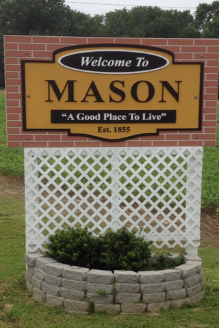
Mason is a town in Tipton County, Tennessee. The population was 1,609 at the 2010 census. Mason is located along U.S. Route 70, and is home to a federal detention facility.

<span class="mw-page-title-main">Shelton, Washington</span> City in Washington, United States

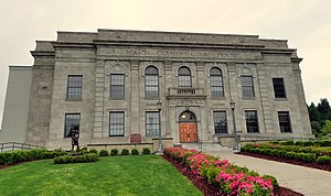
Shelton is a city in and the county seat of Mason County, Washington, United States. Shelton is the westernmost city on Puget Sound. The population was 10,371 at the 2020 census. Shelton has a council–manager form of government and was the last city in Washington to use a mayor–commission form of government.

<span class="mw-page-title-main">Skokomish, Washington</span> CDP in Washington, United States

Skokomish is a census-designated place (CDP) in Mason County, Washington, United States. The population was 617 at the 2010 census. The town is the headquarters of the Skokomish Indian Tribe.

<span class="mw-page-title-main">Mason, West Virginia</span> Town in West Virginia, United States

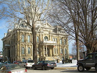
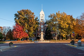
Mason, also known as Mason City, is a town in Mason County, West Virginia, United States. The population was 865 at the 2020 census. It is part of the Point Pleasant, WV–OH Micropolitan Statistical Area.

References

  1. 1 2 "State & County QuickFacts". United States Census Bureau. Retrieved August 19, 2023.
  2. "Find a County". National Association of Counties. Retrieved June 7, 2011.
  3. Washington Agricultural Statistics Service, US Department of Agriculture, as archived at the Internet Archive
  4. "2010 Census Gazetteer Files". United States Census Bureau. August 22, 2012. Retrieved July 7, 2015.
  5. "Annual Estimates of the Resident Population for Counties: April 1, 2020 to July 1, 2022". United States Census Bureau. Retrieved August 19, 2023.
  6. "U.S. Decennial Census". United States Census Bureau. Retrieved January 7, 2014.
  7. "Historical Census Browser". University of Virginia Library. Retrieved January 7, 2014.
  8. "Population of Counties by Decennial Census: 1900 to 1990". United States Census Bureau. Retrieved January 7, 2014.
  9. "Census 2000 PHC-T-4. Ranking Tables for Counties: 1990 and 2000" (PDF). United States Census Bureau. Archived from the original (PDF) on February 26, 2015. Retrieved January 7, 2014.
  10. 1 2 3 "DP-1 Profile of General Population and Housing Characteristics: 2010 Demographic Profile Data". United States Census Bureau. Archived from the original on February 13, 2020. Retrieved March 13, 2016.
  11. "Population, Housing Units, Area, and Density: 2010 – County". United States Census Bureau. Archived from the original on February 13, 2020. Retrieved March 13, 2016.
  12. "DP02 SELECTED SOCIAL CHARACTERISTICS IN THE UNITED STATES – 2006–2010 American Community Survey 5-Year Estimates". United States Census Bureau. Archived from the original on February 13, 2020. Retrieved March 13, 2016.
  13. "DP03 SELECTED ECONOMIC CHARACTERISTICS – 2006–2010 American Community Survey 5-Year Estimates". United States Census Bureau. Archived from the original on February 13, 2020. Retrieved March 13, 2016.
  14. Shephard, Arla (January 11, 2011). "Neatherlin sworn into Mason County Commision". Kitsap Sun. Retrieved May 10, 2024.
  15. "Mason County Commissioner Kevin Shutty Not Seeking Reelection". Hood Canal Communications. Retrieved May 10, 2024.
  16. "County Commissioner - District 3". Mason County. Retrieved May 10, 2024.
  17. Leip, David. "Dave Leip's Atlas of U.S. Presidential Elections". uselectionatlas.org. Retrieved April 10, 2018.
  18. The leading "other" candidate, Progressive Theodore Roosevelt, received 464 votes, while Socialist candidate Eugene Debs received 339 votes, Prohibition candidate Eugene Chafin received 22 votes, and Socialist Labor candidate Arthur Reimer received 12 votes.
  19. Arla Shephard Bull (November 16, 2017). "Mason General to build new medical office building".
  20. 2018 Facility Fees, Washington State Department of Health, 2018, retrieved March 14, 2020
  21. "Public Hospital District Directory". Association of Washington Public Hospital Districts. Retrieved March 14, 2020.

47°21′N123°11′W / 47.35°N 123.18°W / 47.35; -123.18