Whitman County, Washington

Last updated

Whitman County
Colfax Post Office.jpg
Map of Washington highlighting Whitman County.svg
Location within the U.S. state of Washington
Washington in United States.svg
Washington's location within the U.S.
Coordinates: 46°53′N117°31′W / 46.89°N 117.52°W / 46.89; -117.52
CountryFlag of the United States.svg United States
StateFlag of Washington.svg  Washington
FoundedNovember 29, 1871
Named for Marcus Whitman
Seat Colfax
Largest city Pullman
Area
  Total2,178 sq mi (5,640 km2)
  Land2,159 sq mi (5,590 km2)
  Water19 sq mi (50 km2)  0.9%
Population
 (2020)
  Total47,973
  Estimate 
(2022)
47,619 Decrease2.svg
  Density22/sq mi (8/km2)
Time zone UTC−8 (Pacific)
  Summer (DST) UTC−7 (PDT)
Congressional district 5th
Website www.whitmancounty.org

Whitman County is a county located in the U.S. state of Washington. As of the 2020 census, the population was 47,973. [1] The county seat is Colfax, [2] and its largest city is Pullman.

Contents

The county was formed from Stevens County in 1871. [3] It is named after Marcus Whitman, a Presbyterian missionary who, with his wife Narcissa, was killed in 1847 by members of the Cayuse tribe. [4]

Whitman County comprises the Pullman, Washington Metropolitan Statistical Area.

History

The area delineated by the future Washington state boundary began to be colonized at the start of the nineteenth century, both by Americans and Canadians. However, the majority of Canadian exploration and interest in the land was due to the fur trade, whereas American settlers were principally seeking land for agriculture and cattle raising. The Treaty of 1818 provided for dual control of this area by US and Canadian government officials. During this period, the future Washington Territory was divided into two administrative zones: Clark County and Lewis County (made official in 1845).

The dual-control concept was unwieldy and led to continual argument, and occasional conflict. The status of the Washington area was settled in 1846, when the Oregon Treaty ceded the land south of North latitude 49 degrees to American control.

In 1854, Skamania County was split from the original Clark County. Also in 1854, Walla Walla County was split from the new Skamania County. In 1863, Stevens County was split from Walla Walla County, and in 1871, a portion of Stevens County was set off to form Whitman County. The 1871 shape of Whitman County was considerably larger than its present boundary, as Adams, Franklin, and Lincoln counties were sectioned off from Whitman County in 1883. After that, Whitman County retained its shape, including through the period after Washington became the 42nd state of the Union in 1889.

Geography

According to the United States Census Bureau, the county has a total area of 2,178 square miles (5,640 km2), of which 2,159 square miles (5,590 km2) is land and 19 square miles (49 km2) (0.9%) is water. [5] Whitman County is part of the Palouse, a wide and rolling prairie-like region of the middle Columbia basin.

Rivers

Lakes and reservoirs

Summits and peaks

Notable parks

Adjacent counties

Major highways

Airports

Demographics

Historical population
CensusPop.Note
1880 7,014
1890 19,109172.4%
1900 25,36032.7%
1910 33,28031.2%
1920 31,323−5.9%
1930 28,014−10.6%
1940 27,221−2.8%
1950 32,46919.3%
1960 31,263−3.7%
1970 37,90021.2%
1980 40,1035.8%
1990 38,775−3.3%
2000 40,7405.1%
2010 44,7769.9%
2020 47,9737.1%
2022 (est.)47,619 [6] −0.7%
U.S. Decennial Census [7]
1790–1960 [8] 1900–1990 [9]
1990–2000 [10] 2010–2020 [1]

2000 census

As of the 2000 census, there were 40,740 people, 15,257 households, and 8,055 families living in the county. The population density was 19 people per square mile (7.3 people/km2). There were 16,676 housing units at an average density of 8 units per square mile (3.1 units/km2). The racial makeup of the county was 88.07% White, 1.53% Black or African American, 0.73% Native American, 5.55% Asian, 0.27% Pacific Islander, 1.22% from other races, and 2.63% from two or more races. 2.99% of the population were Hispanic or Latino of any race. 21.9% were of German, 9.8% English, 8.6% Irish, 8.3% United States or American and 6.6% Norwegian ancestry.

There were 15,257 households, out of which 24.60% had children under the age of 18 living with them, 44.20% were married couples living together, 6.20% had a female householder with no husband present, and 47.20% were non-families. 29.40% of all households were made up of individuals, and 7.10% had someone living alone who was 65 years of age or older. The average household size was 2.31 and the average family size was 2.91.

In the county, the population was spread out, with 18.10% under the age of 18, 32.60% from 18 to 24, 24.00% from 25 to 44, 16.00% from 45 to 64, and 9.20% who were 65 years of age or older. The median age was 25 years. For every 100 females there were 102.50 males. For every 100 females age 18 and over, there were 101.90 males.

The median income for a household in the county was $28,584, and the median income for a family was $44,830. Males had a median income of $33,381 versus $27,046 for females. The per capita income for the county was $15,298. About 11.00% of families and 25.60% of the population were below the poverty line, including 16.50% of those under age 18 and 5.50% of those age 65 or over.

2010 census

As of the 2010 census, there were 44,776 people, 17,468 households, and 8,130 families living in the county. [11] The population density was 20.7 people per square mile (8.0 people/km2). There were 19,323 housing units at an average density of 8.9 units per square mile (3.4 units/km2). [12] The racial makeup of the county was 84.6% white, 7.8% Asian, 1.7% black or African American, 0.7% American Indian, 0.2% Pacific islander, 1.4% from other races, and 3.6% from two or more races. Those of Hispanic or Latino origin made up 4.6% of the population. [11] In terms of ancestry, 29.4% were German, 14.5% were English, 13.4% were Irish, 7.1% were Norwegian, and 4.1% were American. [13]

Of the 17,468 households, 20.8% had children under the age of 18 living with them, 38.4% were married couples living together, 5.4% had a female householder with no husband present, 53.5% were non-families, and 32.7% of all households were made up of individuals. The average household size was 2.22 and the average family size was 2.86. The median age was 24.4 years. [11]

The median income for a household in the county was $36,368 and the median income for a family was $61,598. Males had a median income of $46,663 versus $34,496 for females. The per capita income for the county was $19,506. About 10.7% of families and 27.6% of the population were below the poverty line, including 13.3% of those under age 18 and 5.7% of those age 65 or over. [14]

Politics

Despite the county historically voting for Republicans, Whitman County has a reputation as being far more socially liberal than other counties in Eastern Washington due to the presence of Washington State University in Pullman. It is part of Washington's 5th congressional district and is represented by Republican Cathy McMorris Rodgers. Quite conservative, rural Whitman was one of only three counties in the state to be won by Barry Goldwater in 1964. Since that election, the county has been won by the winning candidate in all but three presidential elections, 1976, 2012, and 2016. Richard Nixon, Ronald Reagan, Bill Clinton, and George W. Bush each won the county twice.

In 2008, Barack Obama received 51.57% of the Whitman County vote. [15] In 2012, he received 46.9% of the vote, with Mitt Romney winning with a 49.7% plurality. [16] Whitman was the only county in eastern Washington to approve same-sex marriage via Referendum 74. It was the only county to vote in favor of Referendum 74 while voting for the Republican candidate for president. Whitman County voters also approved marijuana legalization via Initiative 502.

By 2016, the county was considered Democratic in regards to federal elections. Hillary Clinton won the county in 2016 and also voted for Patty Murray in 2016. However, Republican Bill Bryant won this county over incumbent Democrat Jay Inslee by a percentage point in the concurrent gubernatorial election. In the 2020 elections, the majority of the county voted for Democrat Joe Biden for president and re-elected Inslee for governor. Both received majority of the county vote with Inslee becoming the first Democratic gubernatorial candidate to win a county in Eastern Washington since Gary Locke in 2000. However, the county still votes Republican in congressional elections. [17]

In 2020, 52.9% of residents voted for Biden while 42.9% voted for Trump, a 10% margin for Biden. [18]

United States presidential election results for Whitman County, Washington [19] [20]
Year Republican Democratic Third party
No.%No.%No.%
2020 9,06742.92%11,18452.94%8754.14%
2016 7,40341.06%8,14645.19%2,47913.75%
2012 8,50749.26%8,03746.54%7264.20%
2008 8,10446.07%9,07051.57%4152.36%
2004 9,39752.17%8,28746.01%3281.82%
2000 9,00355.45%6,50940.09%7254.47%
1996 6,73442.37%7,26245.69%1,89911.95%
1992 6,42836.78%7,63743.69%3,41319.53%
1988 7,68050.09%7,40348.28%2501.63%
1984 10,02159.48%6,62139.30%2071.23%
1980 8,63650.73%5,72633.63%2,66215.64%
1976 8,16854.21%6,19741.13%7034.67%
1972 9,54858.70%6,24838.41%4702.89%
1968 7,81056.64%5,21837.84%7615.52%
1964 6,76549.97%6,76049.93%130.10%
1960 8,06959.58%5,45840.30%170.13%
1956 8,57263.81%4,85436.13%80.06%
1952 8,90565.67%4,61134.00%440.32%
1948 6,41150.32%6,01547.21%3142.46%
1944 6,00052.22%5,44947.42%410.36%
1940 6,35649.66%6,35149.62%920.72%
1936 3,95533.03%7,75364.75%2652.21%
1932 4,72742.93%5,94553.99%3393.08%
1928 7,06569.94%2,96929.39%670.66%
1924 4,96052.12%1,74518.34%2,81129.54%
1920 6,34464.68%2,80628.61%6596.72%
1916 4,93343.84%5,88852.33%4303.82%
1912 1,98920.00%3,62136.42%4,33343.58%
1908 3,37652.60%2,38637.18%65610.22%
1904 4,09066.48%1,51924.69%5438.83%
1900 2,36642.52%2,82650.78%3736.70%
1896 1,59229.66%3,69068.75%851.58%
1892 2,13137.33%2,06136.10%1,51726.57%

Economy

Whitman County has highly productive agriculture. According to Heart of Washington, Whitman County produces more barley, wheat, dry peas, and lentils than any other county in the United States. [21]

The county is also home to Schweitzer Engineering Laboratories in Pullman.

Education

Pullman is home to Washington State University, the state's land-grant university.

Communities

Cities

Towns

Census-designated place

Unincorporated communities

Ghost town

Images

Communities

Geography

See also

Related Research Articles

<span class="mw-page-title-main">Adams County, Washington</span> County in Washington, United States

Adams County is a county in the U.S. state of Washington. As of the 2020 census, the population was 20,613. The county seat is at Ritzville, and its largest city is Othello. The county was formed out of Whitman County in November 1883 and is named after John Adams, the second President of the United States.

<span class="mw-page-title-main">Nez Perce County, Idaho</span> County in Idaho, United States

Nez Perce County is a county located in the U.S. state of Idaho. As of the 2020 census, the population was 42,090. The county seat is Lewiston. The county is named after the Native American Nez Perce tribe. Nez Perce County is part of the Lewiston, Idaho–WA Metropolitan Statistical Area.

<span class="mw-page-title-main">Yakima County, Washington</span> County in Washington, United States

Yakima County is a county in the U.S. state of Washington. As of the 2020 census, its population was 256,728. The county seat and most populous city is Yakima. The county was formed out of Ferguson County in January 1865 and is named for the Yakama tribe of Native Americans.

<span class="mw-page-title-main">Walla Walla County, Washington</span> County in Washington, United States

Walla Walla County is a county located in the U.S. state of Washington. As of the 2020 census, its population was 62,584. The county seat and largest city is Walla Walla. The county was formed on April 25, 1854 and is named after the Walla Walla tribe of Native Americans.

<span class="mw-page-title-main">Lincoln County, Washington</span> County in Washington, United States

Lincoln County is a county located in the U.S. state of Washington. As of the 2020 census, the population was 10,876, making it the fifth-least populous county in the state. The county seat and largest city is Davenport.

<span class="mw-page-title-main">Klickitat County, Washington</span> County in Washington, United States

Klickitat County is a county located in the U.S. state of Washington. As of the 2020 census, the population was 22,735. The county seat and largest city is Goldendale. The county is named after the Klickitat tribe.

<span class="mw-page-title-main">Garfield County, Washington</span> County in Washington, United States

Garfield County is a county located in the U.S. state of Washington. As of the 2020 census, the population was 2,286, making it the least populous county in Washington; with about 3.2 inhabitants per square mile (1.2/km2), it is also the least densely populated county in Washington. The county seat and only city is Pomeroy.

<span class="mw-page-title-main">Franklin County, Washington</span> County in Washington, United States

Franklin County is a county located in the U.S. state of Washington. As of the 2020 census, its population was 96,749. The county seat and most populous city is Pasco. The county was formed out of Whitman County on November 28, 1883, and is named for Benjamin Franklin.

<span class="mw-page-title-main">Columbia County, Washington</span> County in Washington, United States

Columbia County is a county located in the U.S. state of Washington. As of the 2020 census, the population was 3,952, making it the second-least populous county in Washington. The county seat and largest city is Dayton. The county was created out of Walla Walla County on November 11, 1875, and is named after the Columbia River. Columbia County is included in the Walla Walla, WA Metropolitan Statistical Area.

<span class="mw-page-title-main">Asotin County, Washington</span> County in Washington, United States

Asotin County is a county in the far southeastern corner of the U.S. state of Washington. As of the 2020 census, the population was 22,285. The county seat is at Asotin, and its largest city is Clarkston. The county was created out of Garfield County in 1883 and derives its name from a Nez Perce word meaning "Eel Creek." Asotin County is part of the Lewiston–Clarkston metropolitan area, which includes Nez Perce County, Idaho, and Asotin County.

<span class="mw-page-title-main">Colfax County, New Mexico</span> County in New Mexico, United States

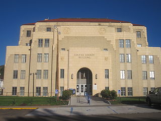
Colfax County is a county in the U.S. state of New Mexico. As of the 2020 census, the population was 12,387. Its county seat is Raton. It is south from the Colorado state line. This county was named for Schuyler Colfax (1823–1885), seventeenth Vice President of the United States under U.S. President Ulysses S. Grant.

<span class="mw-page-title-main">Latah County, Idaho</span> County in Idaho, United States

Latah County is a county located in the north central region of the U.S. state of Idaho. As of the 2020 census, the population was 39,517. The county seat and largest city is Moscow, the home of the University of Idaho, the state's flagship university.

<span class="mw-page-title-main">Washtucna, Washington</span> Town in Washington, United States

Washtucna is a town in Adams County, Washington, United States. The population was 211 at the 2020 census, a 1% increase over the previous census. The town was named for a lake 12 miles from the town in Franklin County which was in turn named after a Palouse Native American chief.

<span class="mw-page-title-main">Pomeroy, Washington</span> City in Washington, United States

Pomeroy is a city in Garfield County, Washington, United States. The population was 1,425 at the 2010 census. It is the county seat of and only incorporated city in Garfield County.

<span class="mw-page-title-main">Colfax, Washington</span> City in Washington, United States

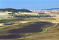
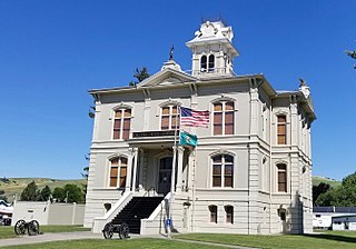
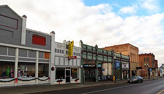
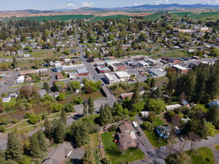
Colfax is a city and the county seat of Whitman County, Washington, United States. The population was 2,782 at the 2020 census, making Colfax the second largest city in Whitman County behind Pullman. It is situated amidst wheat-covered hills in a valley at the confluence of the north and south forks of the Palouse River. U.S. Route 195, which forms the town's main street, intersects with State Route 26 at the north end of town; in the past, Colfax also lay at the junction of three major railway lines. It is part of the Pullman–Moscow combined statistical area. It was named after Schuyler Colfax, the vice president from 1869–73.

<span class="mw-page-title-main">Colton, Washington</span> Town in Washington, United States

Colton is a town in Whitman County, Washington, United States. The population was 418 at the 2010 census.

<span class="mw-page-title-main">Oakesdale, Washington</span> Town in Washington, United States

Oakesdale is a town in Whitman County, Washington, United States. The population was 422 at the 2010 census.

<span class="mw-page-title-main">Palouse, Washington</span> City in Washington, United States

Palouse is a city in Whitman County, Washington, United States. The population was 998 at the 2010 census.

<span class="mw-page-title-main">Pullman, Washington</span> City in Washington, United States

Pullman is the most populous city in Whitman County, located in southeastern Washington within the Palouse region of the Pacific Northwest. The population was 32,901 at the 2020 census, and estimated to be 32,508 in 2022. Originally founded as Three Forks, the city was renamed after industrialist George Pullman in 1884.

<span class="mw-page-title-main">Rosalia, Washington</span> Town in Washington, United States

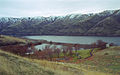
Rosalia is a town in Whitman County, Washington, United States. It is an agricultural community in the Palouse region, at an elevation of 2,238 feet (682 m) above sea level. Its population was 550 at the 2010 census.

References

  1. 1 2 "State & County QuickFacts". United States Census Bureau. Retrieved August 19, 2023.
  2. "Find a County". National Association of Counties. Retrieved June 7, 2011.
  3. "Milestones for Washington State History Part 2: 1851 to 1900". HistoryLink.org. March 6, 2003.
  4. Meany, Edmond S. (1923). Origin of Washington geographic names. Seattle: University of Washington Press. p. 348.
  5. "2010 Census Gazetteer Files". United States Census Bureau. August 22, 2012. Retrieved July 16, 2015.
  6. "Annual Estimates of the Resident Population for Counties: April 1, 2020 to July 1, 2022". United States Census Bureau. Retrieved August 19, 2023.
  7. "U.S. Decennial Census". United States Census Bureau. Retrieved January 8, 2014.
  8. "Historical Census Browser". University of Virginia Library. Retrieved January 8, 2014.
  9. "Population of Counties by Decennial Census: 1900 to 1990". United States Census Bureau. Retrieved January 8, 2014.
  10. "Census 2000 PHC-T-4. Ranking Tables for Counties: 1990 and 2000" (PDF). United States Census Bureau. Archived from the original (PDF) on February 26, 2015. Retrieved January 8, 2014.
  11. 1 2 3 "Profile of General Population and Housing Characteristics: 2010 Demographic Profile Data". United States Census Bureau. Archived from the original on February 13, 2020. Retrieved March 6, 2016.
  12. "Population, Housing Units, Area, and Density: 2010 - County". United States Census Bureau. Archived from the original on February 13, 2020. Retrieved March 6, 2016.
  13. "Selected Social Characteristics in the United States – 2006-2010 American Community Survey 5-Year Estimates". United States Census Bureau. Archived from the original on February 13, 2020. Retrieved March 6, 2016.
  14. "Selected Economic Characteristics – 2006-2010 American Community Survey 5-Year Estimates". United States Census Bureau. Archived from the original on February 13, 2020. Retrieved March 6, 2016.
  15. "Dave Leip's Atlas of U.S. Presidential Elections - Compare Maps". uselectionatlas.org. Retrieved March 7, 2015.
  16. "2012 Washington state election results". The Seattle Times. Retrieved March 7, 2015.
  17. Leadingham, Scott (November 19, 2020). "Incumbent's Advantage: Why Whitman County Votes For Biden And Inslee, But GOP For Congress". Northwest Public Broadcasting. Retrieved August 24, 2021.
  18. Steven Shepard. "Live election results: 2020 Washington results". Politico.com. Retrieved December 13, 2021.
  19. Leip, David. "Dave Leip's Atlas of U.S. Presidential Elections". uselectionatlas.org. Retrieved April 10, 2018.
  20. The leading "other" candidate, Progressive Theodore Roosevelt, received 3,061 votes, while Socialist candidate Eugene Debs received 631 votes, Prohibition candidate Eugene Chafin received 617 votes, and Socialist Labor candidate Arthur Reimer received 24 votes.
  21. "Heart of Washington". August 29, 2003. Archived from the original on August 29, 2003. Retrieved December 10, 2018.

46°53′N117°31′W / 46.89°N 117.52°W / 46.89; -117.52