Franklin County, Washington

Last updated

Franklin County
Franklin County Courthouse in Pasco, Washington.JPG
Franklin County Courthouse in Pasco
Map of Washington highlighting Franklin County.svg
Location within the U.S. state of Washington
Washington in United States.svg
Washington's location within the U.S.
Coordinates: 46°32′N118°54′W / 46.54°N 118.9°W / 46.54; -118.9
CountryFlag of the United States.svg United States
StateFlag of Washington.svg  Washington
FoundedNovember 28, 1883
Named for Benjamin Franklin
Seat Pasco
Largest cityPasco
Area
  Total1,265 sq mi (3,280 km2)
  Land1,242 sq mi (3,220 km2)
  Water23 sq mi (60 km2)  1.8%
Population
 (2020)
  Total96,749
  Estimate 
(2022)
98,678 Increase2.svg
  Density71/sq mi (27/km2)
Time zone UTC−8 (Pacific)
  Summer (DST) UTC−7 (PDT)
Congressional districts 4th, 5th
Website www.co.franklin.wa.us

Franklin County is a county located in the U.S. state of Washington. As of the 2020 census, its population was 96,749. [1] The county seat and most populous city is Pasco. [2] The county was formed out of Whitman County on November 28, 1883, [3] and is named for Benjamin Franklin. [4]

Contents

Franklin County is included in the Tri-Cities metropolitan area. Together, Kennewick, Richland and Pasco comprise Washington's Tri-Cities.

Geography

According to the United States Census Bureau, the county has a total area of 1,265 square miles (3,280 km2), of which 1,242 square miles (3,220 km2) is land and 23 square miles (60 km2) (1.8%) is water. [5]

Geographic features

Major highways

Adjacent counties

National protected areas

Demographics

Historical population
CensusPop.Note
1890 696
1900 486−30.2%
1910 5,153960.3%
1920 5,87714.1%
1930 6,1374.4%
1940 6,3072.8%
1950 13,563115.0%
1960 23,34272.1%
1970 25,81610.6%
1980 35,02535.7%
1990 37,4737.0%
2000 49,34731.7%
2010 78,16358.4%
2020 96,74923.8%
2022 (est.)98,678 [6] 2.0%
U.S. Decennial Census [7]
1790–1960 [8] 1900–1990 [9]
1990–2000 [10] 2010–2020 [1]

Franklin County, along with Adams County, have the highest per capita percentage of Latino residents in the state. [11]

2020 census

as of the 2020 census, there were 96,749 people in Franklin County.[ citation needed ]

2010 census

As of the 2010 census, there were 78,163 people, 23,245 households, and 18,163 families residing in the county. [12] The population density was 62.9 inhabitants per square mile (24.3/km2). There were 24,423 housing units at an average density of 19.7 per square mile (7.6/km2). [13] The racial makeup of the county was 60.5% white, 1.9% black or African American, 1.8% Asian, 0.7% American Indian, 0.1% Pacific islander, 31.8% from other races, and 3.2% from two or more races. Those of Hispanic or Latino origin made up 51.2% of the population. [12] In terms of ancestry, 13.1% were German, 6.8% were English, 6.5% were Irish, and 3.3% were American. [14]

Of the 23,245 households, 49.9% had children under the age of 18 living with them, 57.9% were married couples living together, 13.4% had a female householder with no husband present, 21.9% were non-families, and 16.4% of all households were made up of individuals. The average household size was 3.28 and the average family size was 3.68. The median age was 28.4 years. [12]

The median income for a household in the county was $47,749 and the median income for a family was $52,218. Males had a median income of $40,604 versus $29,517 for females. The per capita income for the county was $18,660. About 16.5% of families and 19.9% of the population were below the poverty line, including 25.6% of those under age 18 and 13.7% of those age 65 or over. [15]

The 2019 county population is estimated to be 95,222, a 21.8% increase since 2010. This far outpaces Washington State's overall growth of 13.2% over the same time interval, and puts Franklin County among the fastest-growing counties in the nation.

In 2018 the county contained 28,647 housing units.

Communities

Cities

Census-designated places

Unincorporated communities

Government

Franklin County has a Board of County Commissioners which is the governmental authority of the county. The board consists of three commissioners; they are elected by the voters and serve four-year terms. [16] Other elected county officials include Assessor, Auditor, Clerk, Coroner, Prosecuting Attorney, Sheriff, and Treasurer. [17]

Politics

United States presidential election results for Franklin County, Washington [18]
Year Republican Democratic Third party
No.%No.%No.%
2020 18,03955.67%13,34041.17%1,0253.16%
2016 13,20653.65%8,88636.10%2,52210.25%
2012 13,74860.39%8,39836.89%6182.71%
2008 12,03760.81%7,36137.19%3972.01%
2004 10,75766.57%5,18832.11%2141.32%
2000 8,59463.13%4,65334.18%3672.70%
1996 5,94649.16%4,96141.01%1,1899.83%
1992 4,48641.02%3,74334.22%2,70824.76%
1988 6,48856.65%4,77241.67%1921.68%
1984 7,72462.96%4,32835.28%2161.76%
1980 7,32761.26%3,71931.09%9157.65%
1976 5,67154.51%4,36942.00%3633.49%
1972 5,97256.75%3,86736.75%6846.50%
1968 4,23444.22%4,03842.17%1,30313.61%
1964 3,61535.94%6,37563.38%680.68%
1960 4,20144.65%5,15654.80%520.55%
1956 3,76346.51%4,32253.42%50.06%
1952 3,29153.89%2,79845.82%180.29%
1948 1,54137.31%2,52561.14%641.55%
1944 1,38140.97%1,97458.56%160.47%
1940 1,08436.34%1,86862.62%311.04%
1936 62223.98%1,78468.77%1887.25%
1932 83833.89%1,54062.27%953.84%
1928 1,33961.96%79936.97%231.06%
1924 70931.15%23710.41%1,33058.44%
1920 83944.46%57130.26%47725.28%
1916 67135.02%1,11057.93%1357.05%
1912 29316.41%61234.29%88049.30%
1908 64352.97%48539.95%867.08%
1904 57269.25%22327.00%313.75%
1900 5237.41%8158.27%64.32%
1896 3824.84%11373.86%21.31%
1892 2823.53%5445.38%3731.09%

Franklin is a strongly Republican county in Presidential elections. No Democratic presidential candidate has carried Franklin County since Lyndon B. Johnson’s 1964 landslide, and the last Democratic gubernatorial candidate it backed was Dixy Lee Ray in 1976. [19]

See also

Notes

    Related Research Articles

    <span class="mw-page-title-main">Adams County, Washington</span> County in Washington, United States

    Adams County is a county in the U.S. state of Washington. As of the 2020 census, the population was 20,613. The county seat is at Ritzville, and its largest city is Othello. The county was formed out of Whitman County in November 1883 and is named after John Adams, the second President of the United States.

    <span class="mw-page-title-main">Benton County, Washington</span> County in Washington, United States

    Benton County is a county in the south-central portion of the U.S. state of Washington. As of the 2020 census, its population was 206,873. The county seat is Prosser, and its most populous city is Kennewick. The Columbia River demarcates the county's north, south, and east boundaries.

    <span class="mw-page-title-main">Norfolk County, Massachusetts</span> County in Massachusetts, United States

    Norfolk County is located in the U.S. state of Massachusetts. At the 2020 census, the population was 725,981. Its county seat is Dedham. It is the fourth most populous county in the United States whose county seat is neither a city nor a borough, and it is the second most populous county that has a county seat at a town. The county was named after the English county of the same name. Two towns, Cohasset and Brookline, are exclaves.

    <span class="mw-page-title-main">Braxton County, West Virginia</span> County in West Virginia, United States

    Braxton County is a county in the central part of the U.S. state of West Virginia. As of the 2020 census, the population was 12,447. The county seat is Sutton. The county was formed in 1836 from parts of Lewis, Kanawha, and Nicholas counties and named for Carter Braxton, a Virginia statesman and signer of the Declaration of Independence.

    <span class="mw-page-title-main">Whitman County, Washington</span> County in Washington, United States

    Whitman County is a county located in the U.S. state of Washington. As of the 2020 census, the population was 47,973. The county seat is Colfax, and its largest city is Pullman.

    <span class="mw-page-title-main">Wahkiakum County, Washington</span> County in Washington, United States

    Wahkiakum County is a county located in the U.S. state of Washington. As of the 2020 census, the population was 4,422, making it one of the least populous counties in Washington. The county seat and only incorporated town is Cathlamet. The county was formed out of Cowlitz County in April 1854 and is named for Chief Wahkiakum of the Chinook, who is buried in the Pioneer Cemetery in Cathlamet.

    <span class="mw-page-title-main">Pend Oreille County, Washington</span> County in Washington, United States

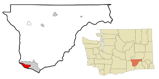
    Pend Oreille County is a county located in the northeast corner of the U.S. state of Washington, along the Canada–US border. As of the 2020 census, the population was 13,401. The county seat and largest city is Newport.

    <span class="mw-page-title-main">Lincoln County, Washington</span> County in Washington, United States

    Lincoln County is a county located in the U.S. state of Washington. As of the 2020 census, the population was 10,876, making it the fifth-least populous county in the state. The county seat and largest city is Davenport.

    <span class="mw-page-title-main">Klickitat County, Washington</span> County in Washington, United States

    Klickitat County is a county located in the U.S. state of Washington. As of the 2020 census, the population was 22,735. The county seat and largest city is Goldendale. The county is named after the Klickitat tribe.

    <span class="mw-page-title-main">Garfield County, Washington</span> County in Washington, United States

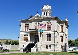
    Garfield County is a county located in the U.S. state of Washington. As of the 2020 census, the population was 2,286, making it the least populous county in Washington; with about 3.2 inhabitants per square mile (1.2/km2), it is also the least densely populated county in Washington. The county seat and only city is Pomeroy.

    <span class="mw-page-title-main">Douglas County, Washington</span> County in Washington, United States

    Douglas County is a county located in the U.S. state of Washington. As of the 2020 census, its population was 42,938. The county seat is Waterville, while its largest settlement is East Wenatchee. The county was created out of Lincoln County on November 28, 1883 and is named for American statesman Stephen A. Douglas.

    <span class="mw-page-title-main">Columbia County, Washington</span> County in Washington, United States

    Columbia County is a county located in the U.S. state of Washington. As of the 2020 census, the population was 3,952, making it the second-least populous county in Washington. The county seat and largest city is Dayton. The county was created out of Walla Walla County on November 11, 1875, and is named after the Columbia River. Columbia County is included in the Walla Walla, WA Metropolitan Statistical Area.

    <span class="mw-page-title-main">Clatsop County, Oregon</span> County in Oregon, United States

    Clatsop County is one of the 36 counties in the U.S. state of Oregon. As of the 2020 census, the population was 41,072. The county seat is Astoria. The county is named for the Clatsop tribe of Native Americans, who lived along the coast of the Pacific Ocean prior to European settlement. Clatsop County comprises the Astoria, OR Micropolitan Statistical Area, or Sunset Empire, and is located in Northwest Oregon.

    <span class="mw-page-title-main">Preble County, Ohio</span> County in Ohio, United States

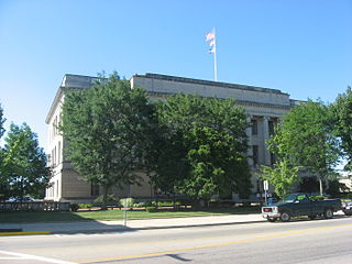
    Preble County is a county located in the U.S. state of Ohio. As of the 2020 census, the population was 40,999, down 3.0% from the 2010 census population of 42,270. Its county seat is Eaton. The county was formed on February 15, 1808, from portions of Butler and Montgomery Counties. It is named for Edward Preble, a naval officer who fought in the American Revolutionary War and against the Barbary Pirates.

    <span class="mw-page-title-main">Fayette County, Ohio</span> County in Ohio, United States

    Fayette County is a county located in the U.S. state of Ohio. As of the 2020 census, the population was 28,951. Its county seat and largest city is Washington Court House. The county was named for the Marquis de Lafayette, a Frenchman who was an officer in the American Army in the Revolution, when established on March 1, 1810.

    <span class="mw-page-title-main">Valencia County, New Mexico</span> County in New Mexico, United States

    Valencia County is a county in the U.S. state of New Mexico. As of the 2020 census, the population was 76,205. The county seat is Los Lunas.

    <span class="mw-page-title-main">Knox County, Maine</span> County in Maine, United States

    Knox County is a county located in the state of Maine, United States. As of the 2020 census, the population was 40,607. Its county seat is Rockland. The county is named for Revolutionary War general and Secretary of War Henry Knox, who lived in the county from 1795 until his death in 1806. The county was established on April 1, 1860, and is the most recent county to be created in Maine. It was carved from parts of Waldo and Lincoln counties. The Union Fair, started in 1868, began as the efforts of the North Knox Agricultural and Horticultural Society.

    <span class="mw-page-title-main">Franklin County, Georgia</span> County in Georgia, United States

    Franklin County is a county located in the northeastern part of the U.S. state of Georgia. As of the 2020 census, the population was 23,424. The county seat is Carnesville. On February 25, 1784, Franklin and Washington became Georgia's eighth and ninth counties, with Franklin named in honor of patriot Benjamin Franklin.

    <span class="mw-page-title-main">Pasco, Washington</span> City in Washington, United States

    Pasco is a city in, and the county seat of, Franklin County, Washington, United States. The population was 77,108 at the 2020 census, and 79,315 as of the July 1, 2022 estimate.

    <span class="mw-page-title-main">West Pasco, Washington</span> Census-designated place in Washington, United States

    West Pasco is a census-designated place (CDP) in Franklin County, Washington, United States. The population was 3,739 at the 2010 census.

    References

    1. 1 2 "State & County QuickFacts". United States Census Bureau. Retrieved August 15, 2023.
    2. "Find a County". National Association of Counties. Archived from the original on May 31, 2011. Retrieved June 7, 2011.
    3. Gannett, Henry (1905). The Origin of Certain Place Names in the United States. Govt. Print. Off. pp.  131.
    4. "2010 Census Gazetteer Files". United States Census Bureau. August 22, 2012. Retrieved July 5, 2015.
    5. "Annual Estimates of the Resident Population for Counties: April 1, 2020 to July 1, 2022". United States Census Bureau. Retrieved August 15, 2023.
    6. "U.S. Decennial Census". United States Census Bureau. Retrieved January 7, 2014.
    7. "Historical Census Browser". University of Virginia Library. Retrieved January 7, 2014.
    8. "Population of Counties by Decennial Census: 1900 to 1990". United States Census Bureau. Retrieved January 7, 2014.
    9. "Census 2000 PHC-T-4. Ranking Tables for Counties: 1990 and 2000" (PDF). United States Census Bureau. Archived from the original (PDF) on February 26, 2015. Retrieved January 7, 2014.
    10. "Franklin County, WA". DataUSA. In 2017, there were 1.28 times more Hispanic or Latino residents (46.8k people) in Franklin County, WA than any other race or ethnicity
    11. 1 2 3 "DP-1 Profile of General Population and Housing Characteristics: 2010 Demographic Profile Data". United States Census Bureau. Archived from the original on February 13, 2020. Retrieved March 1, 2016.
    12. "Population, Housing Units, Area, and Density: 2010 - County". United States Census Bureau. Archived from the original on February 13, 2020. Retrieved March 1, 2016.
    13. "DP02 SELECTED SOCIAL CHARACTERISTICS IN THE UNITED STATES – 2006-2010 American Community Survey 5-Year Estimates". United States Census Bureau. Archived from the original on February 13, 2020. Retrieved March 1, 2016.
    14. "DP03 SELECTED ECONOMIC CHARACTERISTICS – 2006-2010 American Community Survey 5-Year Estimates". United States Census Bureau. Archived from the original on February 13, 2020. Retrieved March 1, 2016.
    15. "Franklin County Commissioner's Office". Franklin County, Washington. Retrieved April 25, 2020.
    16. "Franklin County Elections Department". Franklin County, Washington. Retrieved April 25, 2020.
    17. Leip, David. "Dave Leip's Atlas of U.S. Presidential Elections". uselectionatlas.org. Retrieved April 6, 2018.
    18. Dave Leip. "Gubernatorial General Election Map Comparison – Washington". Dave Leip’s U.S. Election Atlas.

    Further reading

    46°32′N118°54′W / 46.54°N 118.90°W / 46.54; -118.90