Pacific County | |
---|---|
Coordinates: 46°34′N123°47′W / 46.56°N 123.78°W | |
Country | United States |
State | Washington |
Founded | February 4, 1851 |
Named for | Pacific Ocean |
Seat | South Bend |
Largest city | Raymond |
Area | |
• Total | 1,223 sq mi (3,170 km2) |
• Land | 933 sq mi (2,420 km2) |
• Water | 291 sq mi (750 km2) 24% |
Population (2020) | |
• Total | 23,365 |
• Estimate (2022) | 24,113 |
• Density | 19/sq mi (7/km2) |
Time zone | UTC−8 (Pacific) |
• Summer (DST) | UTC−7 (PDT) |
Congressional district | 3rd |
Website | www |
Pacific County is a county in the U.S. state of Washington. As of the 2020 census, the population was 23,365. [1] Its county seat is South Bend, [2] and its largest city is Raymond. The county was formed by the government of Oregon Territory in February 1851 [3] and is named for the Pacific Ocean.
Pacific County is centered on Willapa Bay, a region that provides twenty-five percent of the United States oyster harvest, [4] although forestry, fishing, and tourism are also significant elements of the county's economy.
The area that is now Pacific County was part of Oregon Territory in the first part of the nineteenth century. On December 19, 1845, the Provisional Government of Oregon created two counties (Vancouver and Clark) in its northern portion (which is now the state of Washington). In 1849, the name of Vancouver County was changed to Lewis County, and on February 4, 1851, a portion of Lewis County was partitioned off to become Pacific County. The county's boundaries have not changed since its creation. The unincorporated community of Oysterville, established in 1852, was the first county seat. The county records were stolen from Oysterville and ferried across Willapa Harbor by residents of South Bend, resulting in that town becoming the new county seat in 1893.
According to the United States Census Bureau, the county has an area of 1,223 square miles (3,170 km2), of which 933 square miles (2,420 km2) is land and 291 square miles (750 km2) (24%) is water. [5]
Census | Pop. | Note | %± |
---|---|---|---|
1860 | 420 | — | |
1870 | 738 | 75.7% | |
1880 | 1,645 | 122.9% | |
1890 | 4,358 | 164.9% | |
1900 | 5,983 | 37.3% | |
1910 | 12,532 | 109.5% | |
1920 | 14,891 | 18.8% | |
1930 | 14,970 | 0.5% | |
1940 | 15,928 | 6.4% | |
1950 | 16,558 | 4.0% | |
1960 | 14,674 | −11.4% | |
1970 | 15,796 | 7.6% | |
1980 | 17,237 | 9.1% | |
1990 | 18,882 | 9.5% | |
2000 | 20,984 | 11.1% | |
2010 | 20,920 | −0.3% | |
2020 | 23,365 | 11.7% | |
2022 (est.) | 24,113 | [6] | 3.2% |
U.S. Decennial Census [7] 1790–1960 [8] 1900–1990 [9] 1990–2000 [10] 2010–2020 [1] |
As of the 2010 census, there were 20,920 people, 9,499 households, and 5,707 families living in the county. [11] The population density was 22.4 inhabitants per square mile (8.6/km2). There were 15,547 housing units at an average density of 16.7 per square mile (6.4/km2). [12] The racial makeup of the county was 87.4% white, 2.3% American Indian, 2.0% Asian, 0.4% black or African American, 0.1% Pacific islander, 4.4% from other races, and 3.4% from two or more races. Those of Hispanic or Latino origin made up 8.0% of the population. [11] In terms of ancestry, 23.4% were German, 13.8% were English, 11.9% were Irish, 7.6% were American, 6.2% were Norwegian, and 5.8% were Swedish. [13]
Of the 9,499 households, 20.7% had children under the age of 18 living with them, 47.6% were married couples living together, 8.1% had a female householder with no husband present, 39.9% were non-families, and 33.0% of all households were made up of individuals. The average household size was 2.17 and the average family size was 2.72. The median age was 50.8 years. [11]
The median income for a household in the county was $39,642 and the median income for a family was $51,450. Males had a median income of $44,775 versus $34,538 for females. The per capita income for the county was $23,326. About 12.4% of families and 16.8% of the population were below the poverty line, including 20.4% of those under age 18 and 9.9% of those age 65 or over. [14]
As of the 2000 census, there were 20,984 people, 9,096 households, and 5,885 families living in the county. The population density was 22 people per square mile (8.5 people/km2). There were 13,991 housing units at an average density of 15 per square mile (5.8/km2). The racial makeup of the county was 90.54% White, 0.20% Black or African American, 2.44% Native American, 2.08% Asian, 0.09% Pacific Islander, 1.83% from other races, and 2.82% from two or more races. 5.01% of the population were Hispanic or Latino of any race. 18.0% were of German, 10.8% English, 8.8% Irish and 8.6% United States or American ancestry.
There were 9,096 households, out of which 23.10% had children under the age of 18 living with them, 53.10% were married couples living together, 7.90% had a female householder with no husband present, and 35.30% were non-families. 29.50% of all households were made up of individuals, and 14.30% had someone living alone who was 65 years of age or older. The average household size was 2.27 and the average family size was 2.77.
In the county, the population was spread out, with 21.40% under the age of 18, 6.00% from 18 to 24, 21.20% from 25 to 44, 28.90% from 45 to 64, and 22.60% who were 65 years of age or older. The median age was 46 years. For every 100 females there were 98.30 males. For every 100 females age 18 and over, there were 95.80 males.
The median income for a household in the county was $31,209, and the median income for a family was $39,302. Males had a median income of $33,892 versus $22,982 for females. The per capita income for the county was $17,322. About 9.10% of families and 14.40% of the population were below the poverty line, including 19.70% of those under age 18 and 8.10% of those age 65 or over.
Pacific County, along with neighboring Grays Harbor County, were among the most consistently Democratic counties in the nation. In 2016 and 2020 however, the county, like Grays Harbor County, broke its long streak of backing the Democratic candidate for president, voting for the Republican candidate.
Year | Republican | Democratic | Third party | |||
---|---|---|---|---|---|---|
No. | % | No. | % | No. | % | |
2020 | 6,953 | 49.44% | 6,794 | 48.31% | 317 | 2.25% |
2016 | 5,360 | 48.85% | 4,620 | 42.11% | 992 | 9.04% |
2012 | 4,499 | 42.30% | 5,711 | 53.69% | 426 | 4.01% |
2008 | 4,555 | 41.20% | 6,094 | 55.12% | 406 | 3.67% |
2004 | 4,634 | 44.43% | 5,570 | 53.40% | 227 | 2.18% |
2000 | 4,042 | 42.46% | 4,895 | 51.42% | 582 | 6.11% |
1996 | 2,598 | 28.51% | 5,095 | 55.92% | 1,418 | 15.56% |
1992 | 2,243 | 24.24% | 4,587 | 49.58% | 2,422 | 26.18% |
1988 | 3,073 | 37.48% | 5,017 | 61.18% | 110 | 1.34% |
1984 | 3,613 | 42.90% | 4,679 | 55.56% | 129 | 1.53% |
1980 | 3,132 | 39.09% | 3,727 | 46.52% | 1,153 | 14.39% |
1976 | 2,781 | 37.84% | 4,278 | 58.20% | 291 | 3.96% |
1972 | 3,349 | 46.73% | 3,585 | 50.03% | 232 | 3.24% |
1968 | 2,491 | 37.71% | 3,740 | 56.62% | 374 | 5.66% |
1964 | 1,789 | 26.08% | 5,056 | 73.70% | 15 | 0.22% |
1960 | 3,224 | 45.47% | 3,837 | 54.12% | 29 | 0.41% |
1956 | 3,799 | 49.76% | 3,824 | 50.09% | 12 | 0.16% |
1952 | 3,846 | 50.19% | 3,778 | 49.30% | 39 | 0.51% |
1948 | 2,749 | 38.98% | 3,902 | 55.33% | 401 | 5.69% |
1944 | 2,419 | 39.17% | 3,745 | 60.64% | 12 | 0.19% |
1940 | 2,704 | 37.84% | 4,393 | 61.48% | 48 | 0.67% |
1936 | 1,732 | 26.87% | 4,395 | 68.17% | 320 | 4.96% |
1932 | 1,737 | 31.08% | 3,099 | 55.46% | 752 | 13.46% |
1928 | 3,247 | 67.41% | 1,523 | 31.62% | 47 | 0.98% |
1924 | 2,672 | 64.57% | 501 | 12.11% | 965 | 23.32% |
1920 | 2,607 | 65.57% | 874 | 21.98% | 495 | 12.45% |
1916 | 2,688 | 59.50% | 1,537 | 34.02% | 293 | 6.49% |
1912 | 1,375 | 33.77% | 971 | 23.85% | 1,726 | 42.39% |
1908 | 1,492 | 69.30% | 483 | 22.43% | 178 | 8.27% |
1904 | 1,354 | 76.98% | 258 | 14.67% | 147 | 8.36% |
1900 | 887 | 66.74% | 393 | 29.57% | 49 | 3.69% |
1896 | 925 | 61.22% | 562 | 37.19% | 24 | 1.59% |
1892 | 759 | 52.60% | 559 | 38.74% | 125 | 8.66% |
Stevens County is a county located in the U.S. state of Washington along the Canada–US border. At the 2020 census, its population was 46,445. As of July 2021, the population was estimated to be 47,426. The county seat and largest city is Colville. The county was created in 1863 and named after Isaac Stevens, the first governor of Washington Territory.
Pend Oreille County is a county located in the northeast corner of the U.S. state of Washington, along the Canada–US border. As of the 2020 census, the population was 13,401. The county seat and largest city is Newport.
Okanogan County is a county located in the U.S. state of Washington along the Canada–U.S. border. As of the 2020 census, the population was 42,104. The county seat is Okanogan, while the largest city is Omak. Its area is the largest in the state.
Mason County is a county located in the U.S. state of Washington. As of the 2020 census, the population was 65,726. The county seat and only incorporated city is Shelton. The county was formed out of Thurston County on March 13, 1854. Originally named Sawamish County, it took its present name in 1864 in honor of Charles H. Mason, the first Secretary of Washington Territory.
Garfield County is a county located in the U.S. state of Washington. As of the 2020 census, the population was 2,286, making it the least populous county in Washington; with about 3.2 inhabitants per square mile (1.2/km2), it is also the least densely populated county in Washington. The county seat and only city is Pomeroy.
Clallam County is a county in the U.S. state of Washington. As of the 2020 census, the population was 77,155, with an estimated population of 77,805 in 2022. The county seat and largest city is Port Angeles; the county as a whole comprises the Port Angeles, WA Micropolitan Statistical Area. The name is a Klallam word for "the strong people". The county was formed on April 26, 1854. Located on the Olympic Peninsula, it is south from the Strait of Juan de Fuca, which forms the Canada–US border, as British Columbia's Vancouver Island is across the strait.
Jefferson County is one of the 36 counties in the U.S. state of Oregon. At the 2020 census, the population was 24,502. The county seat is Madras. The county is named after Mount Jefferson, the second tallest mountain in Oregon.
Sandusky County is a county located in the northwestern part of the U.S. state of Ohio. As of the 2020 census, the population was 58,896. Its county seat and largest city is Fremont. The county was formed on February 12, 1820, from portions of Huron County.
Defiance County is a county located in the U.S. state of Ohio. As of the 2020 census, the population was 38,286. Its county seat and largest city is Defiance. The county was named after an early Army fortification, Fort Defiance, which was so named by Mad Anthony Wayne to signify the settlers' "defiance" of the Indians. The Defiance, OH Micropolitan Statistical Area includes all of Defiance County.
Grant County is a county located in the U.S. state of New Mexico. At the 2020 census, the population was 28,185. Its county seat is Silver City. The county was founded in 1868 and named for Ulysses S. Grant, the 18th President of the United States.
Mineral County is a county located in the U.S. state of Nevada. As of the 2020 census, the population was 4,554, making it the fifth-least populous county in Nevada. Its county seat is Hawthorne.
Clearwater County is a county located in the U.S. state of Idaho. As of the 2020 census, the population was 8,734. The county seat is Orofino. Established in 1911, the county was named after the Clearwater River.
Cedarville is a village in Greene County, Ohio, United States. The village is within the Dayton Metropolitan Statistical Area. The population was 4,257 at the 2020 census.
Evendale is a village in Hamilton County, Ohio, United States, within the Cincinnati metropolitan area. The population was 2,669 at the 2020 census.
Castle Rock is a city in Cowlitz County, Washington, United States. Located between the Willapa Hills and the western base of Mount St. Helens, Castle Rock is at the heart of Washington timber country in the Pacific temperate rain forest. Castle Rock is part of the Longview, Washington Metropolitan Statistical Area; the population was 2,446 as of the 2020 census.
Pe Ell is a town in Lewis County, Washington, United States. The population was 642 at the 2020 census.
Naselle is a census-designated place (CDP) in Pacific County, Washington, United States located about 23 miles (37 km) from the mouth of the Columbia River. The population was 419 at the 2010 census. The valley's Naselle River flows west into nearby Willapa Bay and then into the Pacific Ocean. Close about the town lie the evergreen-covered Willapa Hills. The river's name has been spelled Nasel and Nasal. An early settler along the river called it the Kenebec. The name comes from the Nisal Indians, a Chinookan tribe formerly residing on the river.
Raymond is a city in Pacific County, Washington, United States. The population was 2,882 at the 2010 census. The 2020 census showed the population of 3,081, an increase of 6.4%. The town's economy has traditionally been based on logging and fishing, together with a limited amount of tourism.
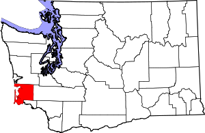
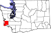
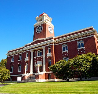
South Bend is a city in and the county seat of Pacific County, Washington, United States. The population was 1,637 as of the 2010 census. The town is widely-known for its oyster production and scenery.
Willapa is a census-designated place (CDP) in Pacific County, Washington, east of the city of Raymond. The population was 210 as of the 2010 census. The name comes from that of the Willapa people, an Athapaskan-speaking people, now extinct, who occupied the Willapa River valley, which was similarly named after the Willapa people, along which the census-designated place Willapa is located.
Media related to Pacific County, Washington at Wikimedia Commons