Douglas County, Washington

Last updated

Douglas County
Waterville-Douglas-County Court House IMG 1832.jpg
County Courthouse
Douglas County wa seal.png
Map of Washington highlighting Douglas County.svg
Location within the U.S. state of Washington
Washington in United States.svg
Washington's location within the U.S.
Coordinates: 47°44′N119°41′W / 47.74°N 119.69°W / 47.74; -119.69
CountryFlag of the United States.svg United States
StateFlag of Washington.svg  Washington
FoundedNovember 28, 1883
Named for Stephen A. Douglas
Seat Waterville
Largest city East Wenatchee
Area
  Total1,849 sq mi (4,790 km2)
  Land1,819 sq mi (4,710 km2)
  Water29 sq mi (80 km2)  1.6%
Population
 (2020)
  Total42,938
  Estimate 
(2022)
44,192 Increase2.svg
  Density22/sq mi (8/km2)
Time zone UTC−8 (Pacific)
  Summer (DST) UTC−7 (PDT)
Congressional district 4th
Website www.douglascountywa.net

Douglas County is a county located in the U.S. state of Washington. As of the 2020 census, its population was 42,938. [1] The county seat is Waterville, [2] while its largest settlement is East Wenatchee. The county was created out of Lincoln County on November 28, 1883 [3] and is named for American statesman Stephen A. Douglas.

Contents

Douglas County is part of the Wenatchee, WA Metropolitan Statistical Area.

Geography

According to the United States Census Bureau, the county has a total area of 1,849 square miles (4,790 km2), of which 1,819 square miles (4,710 km2) is land and 29 square miles (75 km2) (1.6%) is water. [4]

Geographic features

Major highways

Adjacent counties

Demographics

Historical population
CensusPop.Note
1890 3,161
1900 4,92655.8%
1910 9,22787.3%
1920 9,3921.8%
1930 7,561−19.5%
1940 8,65114.4%
1950 10,81725.0%
1960 14,89037.7%
1970 16,78712.7%
1980 22,14431.9%
1990 26,20518.3%
2000 32,60324.4%
2010 38,43117.9%
2020 42,93811.7%
2022 (est.)44,192 [5] 2.9%
U.S. Decennial Census [6]
1790–1960 [7] 1900–1990 [8]
1990–2000 [9] 2010–2020 [1]

2000 census

As of the 2000 census, there were 32,603 people, 11,726 households, and 8,876 families living in the county. The population density was 18 people per square mile (6.9 people/km2). There were 12,944 housing units at an average density of 7 units per square mile (2.7 units/km2). The racial makeup of the county was 84.65% White, 0.31% Black or African American, 1.09% Native American, 0.55% Asian, 0.10% Pacific Islander, 10.83% from other races, and 2.48% from two or more races. 19.73% of the population were Hispanic or Latino of any race. 18.0% were of German, 10.0% English, 9.3% United States or American and 7.8% Irish ancestry. 81.5% spoke English, and 17.7% Spanish as their first language.

There were 11,726 households, out of which 38.40% had children under the age of 18 living with them, 61.60% were married couples living together, 9.70% had a female householder with no husband present, and 24.30% were non-families. 20.00% of all households were made up of individuals, and 7.80% had someone living alone who was 65 years of age or older. The average household size was 2.76 and the average family size was 3.16.

In the county, the population was spread out, with 29.50% under the age of 18, 8.20% from 18 to 24, 27.30% from 25 to 44, 22.40% from 45 to 64, and 12.70% who were 65 years of age or older. The median age was 36 years. For every 100 females, there were 98.20 males. For every 100 females age 18 and over, there were 96.00 males.

The median income for a household in the county was $38,464, and the median income for a family was $43,777. Males had a median income of $35,917 versus $24,794 for females. The per capita income for the county was $17,148. About 11.20% of families and 14.40% of the population were below the poverty line, including 21.00% of those under age 18 and 6.90% of those age 65 or over.

2010 census

As of the 2010 census, there were 38,431 people, 13,894 households, and 10,240 families living in the county. [10] The population density was 21.1 inhabitants per square mile (8.1/km2). There were 16,004 housing units at an average density of 8.8 units per square mile (3.4 units/km2). [11] The racial makeup of the county was 79.6% White, 1.1% American Indian, 0.7% Asian, 0.3% black or African American, 0.1% Pacific islander, 15.6% from other races, and 2.6% from two or more races. Those of Hispanic or Latino origin made up 28.7% of the population. [10] In terms of ancestry, 20.2% were German, 11.2% were English, 9.4% were Irish, 6.0% were Norwegian, and 5.0% were American. [12]

Of the 13,894 households, 37.2% had children under the age of 18 living with them, 57.8% were married couples living together, 10.7% had a female householder with no husband present, 26.3% were non-families, and 20.8% of all households were made up of individuals. The average household size was 2.75 and the average family size was 3.18. The median age was 36.8 years. [10]

The median income for a household in the county was $48,708 and the median income for a family was $55,766. Males had a median income of $39,991 versus $31,706 for females. The per capita income for the county was $22,359. About 10.2% of families and 14.3% of the population were below the poverty line, including 22.0% of those under age 18 and 3.7% of those age 65 or over. [13]

Communities

Truck driving through Douglas County on Route 2 Eastern Washington Truck.jpg
Truck driving through Douglas County on Route 2

Cities

Towns

Unincorporated communities

Ghost Towns

Politics

Federally, Douglas County is represented primarily by Dan Newhouse (R) of the 4th while parts of East Wenatchee have been siphoned off into the 8th, represented by Democrat Kim Schrier. It is one of the most strongly Republican counties in the state in presidential elections, and has not voted for a Democratic candidate since 1964, in Lyndon B. Johnson's rout of Barry Goldwater.

United States presidential election results for Douglas County, Washington [16]
Year Republican Democratic Third party
No.%No.%No.%
2020 12,95560.80%7,81136.66%5422.54%
2016 9,60360.39%4,91830.93%1,3808.68%
2012 9,42562.58%5,16634.30%4693.11%
2008 9,09859.52%5,84838.26%3392.22%
2004 8,90066.56%4,30632.20%1661.24%
2000 8,51266.22%3,82229.73%5214.05%
1996 5,68252.01%3,91335.82%1,33012.17%
1992 4,92044.53%3,73133.77%2,39721.70%
1988 5,37858.16%3,76040.66%1091.18%
1984 6,44366.44%3,12732.24%1281.32%
1980 5,17159.38%2,83332.53%7058.10%
1976 4,54753.09%3,80944.48%2082.43%
1972 4,51260.31%2,42032.35%5497.34%
1968 3,23448.52%2,76441.47%66710.01%
1964 2,64341.45%3,72858.47%50.08%
1960 3,24151.07%3,08748.64%180.28%
1956 2,60246.09%3,03453.75%90.16%
1952 2,95455.43%2,36144.30%140.26%
1948 1,70342.23%2,25155.81%791.96%
1944 1,80949.36%1,83249.99%240.65%
1940 1,95949.33%1,97249.66%401.01%
1936 1,02529.75%2,29066.47%1303.77%
1932 1,17935.07%1,94157.73%2427.20%
1928 1,76066.34%86232.49%311.17%
1924 1,07042.19%39815.69%1,06842.11%
1920 1,58757.86%91833.47%2388.68%
1916 1,12534.95%1,91659.52%1785.53%
1912 64220.16%1,35742.61%1,18637.24%
1908 1,94252.20%1,54041.40%2386.40%
1904 1,72271.30%57723.89%1164.80%
1900 51644.44%61552.97%302.58%
1896 33431.01%73368.06%100.93%
1892 34537.70%25327.65%31734.64%

See also

Notes

  1. The community was named after James Beebe, a businessperson in the agriculture industry. [14] A post office called Beebe was established in 1912, and remained in operation until 1942. [15]

Related Research Articles

<span class="mw-page-title-main">Yakima County, Washington</span> County in Washington, United States

Yakima County is a county in the U.S. state of Washington. As of the 2020 census, its population was 256,728. The county seat and most populous city is Yakima. The county was formed out of Ferguson County in January 1865 and is named for the Yakama tribe of Native Americans.

<span class="mw-page-title-main">Kittitas County, Washington</span> County in Washington, United States

Kittitas County is a county located in the U.S. state of Washington. At the 2020 census, its population was 44,337. Its county seat and largest city is Ellensburg. The county was created in November 1883 when it was carved out of Yakima County. Kittitas County comprises the Ellensburg, Washington, Micropolitan Statistical Area.

<span class="mw-page-title-main">Garfield County, Washington</span> County in Washington, United States

Garfield County is a county located in the U.S. state of Washington. As of the 2020 census, the population was 2,286, making it the least populous county in Washington; with about 3.2 inhabitants per square mile (1.2/km2), it is also the least densely populated county in Washington. The county seat and only city is Pomeroy.

<span class="mw-page-title-main">Chelan County, Washington</span> County in Washington, United States

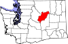
Chelan County is a county in the U.S. state of Washington. As of the 2020 census, its population was 79,074. The county seat and largest city is Wenatchee. The county was created out of Okanogan and Kittitas Counties on March 13, 1899. It derives its name from a Chelan Indian word meaning "deep water," likely a reference to 55-mile (89 km)-long Lake Chelan, which reaches a maximum depth of 1,486 feet (453 m).

<span class="mw-page-title-main">Douglas County, South Dakota</span> County in South Dakota, United States

Douglas County is a county in the U.S. state of South Dakota. As of the 2020 census, the population was 2,835. Its county seat is Armour. The county was established in 1873 and organized in 1882. It is named for Stephen Douglas, Illinois political figure.

<span class="mw-page-title-main">Waterville, Iowa</span> City in Iowa, United States

Waterville is a city in Paint Creek Township, Allamakee County, Iowa, United States. The population was 109 at the time of the 2020 census.

<span class="mw-page-title-main">Conesville, Iowa</span> City in Iowa, United States

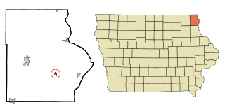
Conesville is a city in Muscatine County, Iowa, United States. The population was 352 at the 2020 census. It is part of the Muscatine Micropolitan Statistical Area.

<span class="mw-page-title-main">Boys Town, Nebraska</span> Village in Douglas County, Nebraska, United States

Boys Town is a village in Douglas County, Nebraska, United States. The population was 410 at the 2020 census. Boys Town is an enclave and a suburb of Omaha.

<span class="mw-page-title-main">Conesville, Ohio</span> Village in Ohio, United States

Conesville is a village in Coshocton County, Ohio, United States, along the Muskingum River. The population was 328 at the 2020 census.

<span class="mw-page-title-main">South Wenatchee, Washington</span> Census-designated place in Washington, United States

South Wenatchee is an unincorporated community and census-designated place (CDP) in Chelan County, Washington, United States. It is part of the Wenatchee–East Wenatchee Metropolitan Statistical Area. The population was 1,522 at the 2020 census.

<span class="mw-page-title-main">Sunnyslope, Washington</span> Census-designated place in Washington, United States

Sunnyslope is an unincorporated community and census-designated place (CDP) in Chelan County, Washington, United States. It is part of the Wenatchee–East Wenatchee Metropolitan Statistical Area. The population was 4,041 at the 2020 census, up from 3,252 at the 2010 census.

<span class="mw-page-title-main">West Wenatchee, Washington</span> Unincorporated community in Washington, United States

West Wenatchee is a former census-designated place (CDP) and now an unincorporated community in Chelan County, Washington, United States. The United States Census Bureau removed the community at the 2010 census, with most of its former area being merged into Wenatchee city limits, raising the population significantly. The area that was West Wenatchee is part of the Wenatchee–East Wenatchee Metropolitan Statistical Area.

<span class="mw-page-title-main">Bridgeport, Washington</span> City in Washington, United States

Bridgeport is a city in Douglas County, Washington. It is part of the Wenatchee−East Wenatchee Metropolitan Statistical Area. Bridgeport's population was 2,409 at the 2010 census. Bridgeport is located near the Chief Joseph Dam.

<span class="mw-page-title-main">East Wenatchee Bench, Washington</span> Former CDP in Washington, United States

East Wenatchee Bench is a former census-designated place in Douglas County, Washington, United States. Most of the area has been annexed by the city of East Wenatchee. It was part of the Wenatchee–East Wenatchee Metropolitan Statistical Area. The population was 13,658 at the 2000 census, but it was no longer a CDP in the 2010 census.

<span class="mw-page-title-main">Mansfield, Washington</span> Town in Washington, United States

Mansfield is a town in Douglas County, Washington, United States. It is part of the Wenatchee–East Wenatchee Metropolitan Statistical Area. The population was 320 at the 2010 census.

<span class="mw-page-title-main">Rock Island, Washington</span> City in Washington, United States

Rock Island is a city in Douglas County, Washington, United States. It is part of the Wenatchee–East Wenatchee Metropolitan Statistical Area. The population was 788 at the 2010 census.

<span class="mw-page-title-main">Waterville, Washington</span> Town in Washington, United States

Waterville is a town in and the county seat of Douglas County, Washington, United States which is known for its wheat industry. As a part of Douglas County, it is part of the Wenatchee-East Wenatchee metropolitan area. The population was 1,134 at the 2020 census.

<span class="mw-page-title-main">Banks Lake South, Washington</span> Census-designated place in Washington, United States

Banks Lake South is a census-designated place (CDP) in Grant County, Washington, United States. The population was 174 at the 2010 census.

<span class="mw-page-title-main">Pateros, Washington</span> City in Washington, United States

Paterospə-TARR-əs is a city in Okanogan County, Washington, United States. The population at the 2010 census was 667, an increase of 3.7% from the 643 in the 2000 census.

<span class="mw-page-title-main">Coulee Dam, Washington</span> Town in Washington, United States

Coulee Dam is a town in Douglas, Grant, and Okanogan counties in the state of Washington. The Douglas County portion of Coulee Dam is part of the Wenatchee–East Wenatchee Metropolitan Statistical Area. The population was 1,211 as of the 2020 census.

References

  1. 1 2 "State & County QuickFacts". United States Census Bureau. Retrieved August 19, 2023.
  2. "Find a County". National Association of Counties. Archived from the original on May 31, 2011. Retrieved June 7, 2011.
  3. "2010 Census Gazetteer Files". United States Census Bureau. August 22, 2012. Retrieved July 4, 2015.
  4. "Annual Estimates of the Resident Population for Counties: April 1, 2020 to July 1, 2022". United States Census Bureau. Retrieved August 19, 2023.
  5. "U.S. Decennial Census". United States Census Bureau. Retrieved January 7, 2014.
  6. "Historical Census Browser". University of Virginia Library. Retrieved January 7, 2014.
  7. "Population of Counties by Decennial Census: 1900 to 1990". United States Census Bureau. Retrieved January 7, 2014.
  8. "Census 2000 PHC-T-4. Ranking Tables for Counties: 1990 and 2000" (PDF). United States Census Bureau. Archived from the original (PDF) on February 26, 2015. Retrieved January 7, 2014.
  9. 1 2 3 "DP-1 Profile of General Population and Housing Characteristics: 2010 Demographic Profile Data". United States Census Bureau. Archived from the original on February 13, 2020. Retrieved March 1, 2016.
  10. "Population, Housing Units, Area, and Density: 2010 – County". United States Census Bureau. Archived from the original on February 13, 2020. Retrieved March 1, 2016.
  11. "DP02 SELECTED SOCIAL CHARACTERISTICS IN THE UNITED STATES – 2006–2010 American Community Survey 5-Year Estimates". United States Census Bureau. Archived from the original on February 13, 2020. Retrieved March 1, 2016.
  12. "DP03 SELECTED ECONOMIC CHARACTERISTICS – 2006–2010 American Community Survey 5-Year Estimates". United States Census Bureau. Archived from the original on February 13, 2020. Retrieved March 1, 2016.
  13. Meany, Edmond S. (1923). Origin of Washington geographic names. Seattle: University of Washington Press. p. 16.
  14. "Post Offices". Jim Forte Postal History. Archived from the original on March 6, 2016. Retrieved July 18, 2016.
  15. Leip, David. "Dave Leip's Atlas of U.S. Presidential Elections". uselectionatlas.org. Retrieved April 6, 2018.

Further reading

47°44′N119°41′W / 47.74°N 119.69°W / 47.74; -119.69