Malden, Washington

Last updated

Malden, Washington
Malden, Washington (1912).jpg
Malden (1912)
Whitman County Washington Incorporated and Unincorporated areas Malden Highlighted.svg
Location within Washington and Whitman County
Coordinates: 47°13′39″N117°28′32″W / 47.22750°N 117.47556°W / 47.22750; -117.47556
Country United States
State Washington
County Whitman
Area
[1]
  Total0.66 sq mi (1.70 km2)
  Land0.66 sq mi (1.70 km2)
  Water0.00 sq mi (0.00 km2)
Elevation
2,139 ft (652 m)
Population
 (2010) [2]
  Total203
  Estimate 
(2019) [3]
206
  Density313.07/sq mi (120.91/km2)
Time zone UTC-8 (Pacific (PST))
  Summer (DST) UTC-7 (PDT)
ZIP code
99149
Area code 509
FIPS code 53-42275 [4]
GNIS feature ID1512423 [5]

Malden is a town in Whitman County, eastern Washington, United States. The population was 203 at the 2010 census. 80 percent of the buildings were destroyed by a wildfire on September 7, 2020.

Contents

History

Malden was officially incorporated on December 20, 1909. Established as a station stop, it was named by railway officials after Malden, Massachusetts. [6] The rural town had a small population.

On September 7, 2020, a large wildfire destroyed approximately 80 percent of buildings in Malden and nearby Pine City. The town's fire station, post office, city hall, library, Masonic Lodge, and several houses were among the buildings destroyed. [7] Most of the town's population was evacuated as the fire approached, while access after the fire was restricted due to a leaking propane tank. [8] [9]

Geography

Pine Creek in 1908 Pine Creek, April 12, 1908 - Malden, Washington (19861380424).jpg
Pine Creek in 1908

According to the United States Census Bureau, the town has a total area of 0.67 square miles (1.74 km2), all of it land. [10]

Climate

This region experiences warm (but not hot) and dry summers, with no average monthly temperatures above 71.6 °F. According to the Köppen Climate Classification system, Malden has a warm-summer Mediterranean climate, abbreviated "Csb" on climate maps. [11]

Demographics

Historical population
CensusPop.Note
1910 798
1920 1,00525.9%
1930 375−62.7%
1940 325−13.3%
1950 3322.2%
1960 292−12.0%
1970 219−25.0%
1980 200−8.7%
1990 189−5.5%
2000 21513.8%
2010 203−5.6%
2019 (est.)206 [3] 1.5%
U.S. Decennial Census [12]
2015 Estimate [13]

2010 census

As of the 2010 census, [2] there were 203 people, 90 households, and 57 families residing in the town. The population density was 303.0 inhabitants per square mile (117.0/km2). There were 118 housing units at an average density of 176.1 per square mile (68.0/km2). The racial makeup of the town was 92.1% White, 2.0% Native American, 1.0% from other races, and 4.9% from two or more races. Hispanic or Latino of any race were 3.9% of the population.

There were 90 households, of which 27.8% had children under the age of 18 living with them, 50.0% were married couples living together, 11.1% had a female householder with no husband present, 2.2% had a male householder with no wife present, and 36.7% were non-families. 34.4% of all households were made up of individuals, and 20% had someone living alone who was 65 years of age or older. The average household size was 2.26 and the average family size was 2.91.

The median age in the town was 50.8 years. 23.6% of residents were under the age of 18; 4% were between the ages of 18 and 24; 18.7% were from 25 to 44; 28.2% were from 45 to 64; and 25.6% were 65 years of age or older. The gender makeup of the town was 50.7% male and 49.3% female.

2000 census

As of the 2000 census, [4] there were 215 people, 93 households, and 65 families residing in the town. The population density was 326.1 people per square mile (125.8/km2). There were 108 housing units at an average density of 163.8 per square mile (63.2/km2). The racial makeup of the town was 96.28% White, 0.47% African American, 2.33% Native American, and 0.93% from two or more races. Hispanic or Latino of any race were 0.93% of the population.

There were 93 households, out of which 30.1% had children under the age of 18 living with them, 49.5% were married couples living together, 15.1% had a female householder with no husband present, and 30.1% were non-families. 29.0% of all households were made up of individuals, and 10.8% had someone living alone who was 65 years of age or older. The average household size was 2.31 and the average family size was 2.82.

In the town, the age distribution of the population shows 26.5% under the age of 18, 5.6% from 18 to 24, 23.3% from 25 to 44, 26.0% from 45 to 64, and 18.6% who were 65 years of age or older. The median age was 42 years. For every 100 females, there were 90.3 males. For every 100 females age 18 and over, there were 92.7 males.

The median income for a household in the town was $26,250, and the median income for a family was $26,250. Males had a median income of $30,000 versus $31,250 for females. The per capita income for the town was $12,477. About 18.0% of families and 17.4% of the population were below the poverty line, including 17.9% of those under the age of eighteen and 4.7% of those 65 or over.

Related Research Articles

<span class="mw-page-title-main">Malden, Illinois</span> Village in Illinois, United States

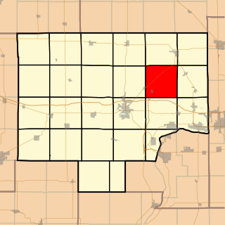
Malden is a village in Bureau County, Illinois, United States. The population was 318 at the 2010 census. It is part of the Ottawa Micropolitan Statistical Area.

<span class="mw-page-title-main">St. Olaf, Iowa</span> City in Iowa, United States

St. Olaf is a large village in Clayton County, Iowa, United States. The population was 106 at the time of the 2020 census, down from 136 in 2000. Swiss Valley has a large cheese packaging plant in St. Olaf. There is also a large feed granary, a post office, and a tavern.

<span class="mw-page-title-main">Guernsey, Iowa</span> City in Iowa, United States

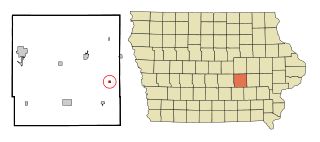
Guernsey is a town in Poweshiek County, Iowa, United States. The population was 63 at the time of the 2020 census.

<span class="mw-page-title-main">Stockholm, Maine</span> Town in the state of Maine, United States

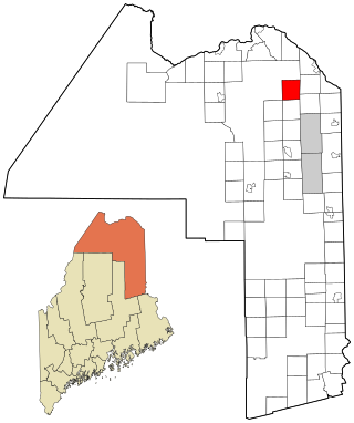
Stockholm is a town in Aroostook County, Maine, United States. The population was 250 at the 2020 census.

Aurora is a town in Hancock County, Maine, United States. The town was named for the goddess of dawn. The population was 93 at the 2020 census.

Sweden is a town in Oxford County, Maine, United States. The population was 406 at the 2020 census. Set among hills, forests and ponds, Sweden includes the village of East Sweden.

<span class="mw-page-title-main">Hillman, Minnesota</span> City in Minnesota, United States

Hillman is a city in Morrison County, Minnesota, United States. The population was 23 at the 2020 census.

<span class="mw-page-title-main">Middletown, Missouri</span> City in Missouri, United States

Middletown is a city in Montgomery County, Missouri, United States. The population was 171 at the 2020 census.

<span class="mw-page-title-main">Tallapoosa, Missouri</span> City in Missouri, United States

Tallapoosa is a city in New Madrid County, Missouri, United States. The population was 78 at the 2020 census.

<span class="mw-page-title-main">Ong, Nebraska</span> Village in Nebraska, United States

Ong is a village in Clay County, Nebraska, United States. The population was 49 at the 2020 census. It is part of the Hastings, Nebraska Micropolitan Statistical Area.

<span class="mw-page-title-main">Malden, New York</span> CDP in New York, United States

Malden-on-Hudson (-), commonly known as Malden, is a hamlet in Ulster County, New York, United States. The population was 365 at the 2020 census.

<span class="mw-page-title-main">Montpelier, North Dakota</span> City in North Dakota, United States

Montpelier is a city in Stutsman County, North Dakota, United States. The population was 85 at the 2020 census. Montpelier was founded in 1885.

<span class="mw-page-title-main">Pocasset, Oklahoma</span> Town in Oklahoma, United States

Pocasset is a town in Grady County, Oklahoma, United States. The population was 183 at the 2020 census, a 17.3% increase from 2010.

<span class="mw-page-title-main">Ward, South Dakota</span> Town in South Dakota, United States

Ward is a town in Moody County, South Dakota, United States. The population was 34 at the 2020 census.

<span class="mw-page-title-main">Junior, West Virginia</span> Town in West Virginia, United States

Junior is a town in Barbour County, West Virginia, United States, situated along the Tygart Valley River. The population was 384 at the 2020 census.

<span class="mw-page-title-main">Handley, West Virginia</span> Town in West Virginia, United States

Handley is a town in Kanawha County, West Virginia, United States. The population was 224 at the 2020 census. Handley was first established in 1877 and known as Upper Creek until July 29, 1881, when its name was changed to Handley for pioneer settlers who farmed the area. Handley has the distinction of bearing a name like no other town in the United States. The town was incorporated November 1972.

<span class="mw-page-title-main">Anawalt, West Virginia</span> Town in West Virginia, United States

Anawalt is a town in McDowell County, West Virginia, United States. At one time it was known as Jeanette. It is named in honor of James White Anawalt, who was then manager of Union Supply Company, a subsidiary of the United States Steel Company. The population was 186 at the 2020 census. Coal mining was the town's chief industry.

<span class="mw-page-title-main">Newburg, West Virginia</span> Town in West Virginia, United States

Newburg is a town in western Preston County, West Virginia, United States. The population was 275 at the 2020 census. It is part of the Morgantown metropolitan area.

<span class="mw-page-title-main">Mabscott, West Virginia</span> Town in West Virginia, United States

Mabscott is a town in Raleigh County, West Virginia, United States. The population was 1,333 at the 2020 census. The town's name is a contraction of the name Mabel Scott, wife of local coal operator Cyrus H. Scott.

<span class="mw-page-title-main">Berlin Township, Bureau County, Illinois</span> Township in Illinois, United States

Berlin Township is one of twenty-five townships in Bureau County, Illinois, United States. As of the 2020 census, its population was 659 and it contained 297 housing units.

References

  1. "2019 U.S. Gazetteer Files". United States Census Bureau. Retrieved August 7, 2020.
  2. 1 2 "U.S. Census website". United States Census Bureau . Retrieved December 19, 2012.
  3. 1 2 "Population and Housing Unit Estimates". United States Census Bureau. May 24, 2020. Retrieved May 27, 2020.
  4. 1 2 "U.S. Census website". United States Census Bureau . Retrieved January 31, 2008.
  5. "US Board on Geographic Names". United States Geological Survey. October 25, 2007. Retrieved January 31, 2008.
  6. Meany, Edmond S. (1923). Origin of Washington geographic names. Seattle: University of Washington Press. p. 157.
  7. Burnside, Tina; Silverman, Hollie (September 8, 2020). "80% of the buildings in an eastern Washington town were destroyed during a Labor Day firestorm". CNN . Retrieved September 8, 2020.
  8. "'A lifetime of my family memories are all gone': Fires burn Malden, Pine City". KREM. September 7, 2020. Retrieved September 8, 2020.
  9. Sokol, Chad; Quinlan, Maggie (September 8, 2020). "'It all happened so fast': Malden, Pine City residents describe fleeing Monday's inferno". The Spokesman-Review . Retrieved September 8, 2020.
  10. "US Gazetteer files 2010". United States Census Bureau. Archived from the original on July 2, 2012. Retrieved December 19, 2012.
  11. Climate Summary for Malden, Washington
  12. United States Census Bureau. "Census of Population and Housing" . Retrieved September 24, 2014.
  13. "Population Estimates". United States Census Bureau. Archived from the original on October 19, 2016. Retrieved July 12, 2016.