Harrietstown, New York

Last updated

Harrietstown, New York
Saranac Lake - Harrietstown Hall.jpg
Harrietstown Hall in Saranac Lake
USA New York location map.svg
Red pog.svg
Harriets-
town
Location within the state of New York
Coordinates: 44°18′13″N74°11′24″W / 44.30361°N 74.19000°W / 44.30361; -74.19000
Country United States
State New York
County Franklin
Government
  Type Town Council
   Town Supervisor Larry L. Miller (R)
   Town Council
Members' List
Area
[1]
  Total213.64 sq mi (553.33 km2)
  Land196.95 sq mi (510.10 km2)
  Water16.69 sq mi (43.23 km2)
Elevation
1,568 ft (478 m)
Population
 (2020)
  Total5,254
  Density25/sq mi (9.5/km2)
Time zone UTC-5 (Eastern (EST))
  Summer (DST) UTC-4 (EDT)
ZIP code
12983
Area code 518
FIPS code 36-033-32314
GNIS feature ID0979050
Website www.harrietstown.org

Harrietstown is a town in Franklin County, New York, United States. The total population was 5,254 at the 2020 census, [2] In 2010 3,879 of the town's residents lived in the village of Saranac Lake on the eastern side of the town. [3]

Contents

Harrietstown is in the southeastern corner of Franklin County and is south of the town of Brighton.

History

The area around Saranac Lake was first settled circa 1819. Harrietstown was formed from the town of Duane in 1841. At the end of the 19th century, it became the location for sanatoria for the treatment of lung diseases, taking advantage of the clear mountain air.

By 1900, the area became a tourist area, assisted by the winter carnivals begun in 1898.

Ames Cottage, Baird Cottage, Camp Intermission, Church Street Historic District, Colbath Cottage, Cottage Row Historic District, Distin Cottage, Drury Cottage, Ellenberger Cottage, Feisthamel-Edelberg Cottage, Feustmann Cottage, E. L. Gray House, Hillside Lodge, Hooey Cottage, Hopkins Cottage, Jennings Cottage, Johnson Cottage, Leis Block, Leis Cottage, Magill Cottage, McBean Cottage, Morgan Cottage, Noyes Cottage, Radwell Cottage, Ryan Cottage, Sarbanes Cottage, Schrader-Griswold Cottage, Seeley Cottage, Sloan Cottage, Smith Cottage, Stonaker Cottage, and Walker Cottage are listed on the National Register of Historic Places. [4]

Geography

Harrietstown is inside the Adirondack Park and is the largest town by area in Franklin County. According to the United States Census Bureau, it has a total area of 213.7 square miles (553.4 km2), of which 196.9 square miles (509.9 km2) is land and 16.8 square miles (43.5 km2), or 7.87%, is water. [5]

The southern town line is the border of Hamilton County and Essex County. The eastern town boundary is also on the border of Essex County. The village of Saranac Lake is on the eastern border of the town, primarily in Harrietstown but extending east into the towns of St. Armand and North Elba in Essex County.

New York State Route 3 runs east–west through the town, while New York State Route 30 and New York State Route 86 traverse the town, running north–south. NY-3 and NY-30 join in the western part of the town. New York State Route 186 connects NY-3 to NY-86 in the northern part of the town.

All of Lower Saranac Lake, most of Middle Saranac Lake, and the southern end of Upper Saranac Lake occupy a band across the central part of the town. They are drained by the Saranac River, which flows east through Oseetah Lake, then north through the village of Saranac Lake before exiting the town to the northeast and draining to Lake Champlain. The Raquette River, which flows northwest to the St. Lawrence River near Massena, crosses the southwestern part of Harrietstown.

Demographics

Historical population
CensusPop.Note
1850 181
1860 34087.8%
1870 41622.4%
1880 53328.1%
1890 1,582196.8%
1900 3,390114.3%
1910 4,75340.2%
1920 4,7970.9%
1930 6,85642.9%
1940 6,117−10.8%
1950 6,014−1.7%
1960 5,664−5.8%
1970 5,643−0.4%
1980 5,604−0.7%
1990 5,6210.3%
2000 5,575−0.8%
2010 5,7092.4%
2020 5,254−8.0%
U.S. Decennial Census [6] [7]

As of the census [8] of 2000, there were 5,575 people, 2,544 households, and 1,340 families residing in the town. The population density was 28.3 inhabitants per square mile (10.9/km2). There were 3,417 housing units at an average density of 17.4 per square mile (6.7/km2). The racial makeup of the town was 97.22% White, 0.52% African American, 0.34% Native American, 0.65% Asian, 0.22% from other races, and 1.06% from two or more races. Hispanic or Latino of any race were 1.06% of the population.

There were 2,544 households, out of which 27.2% had children under the age of 18 living with them, 38.8% were married couples living together, 9.4% had a female householder with no husband present, and 47.3% were non-families. 39.1% of all households were made up of individuals, and 14.3% had someone living alone who was 65 years of age or older. The average household size was 2.16 and the average family size was 2.91.

In the town, the population was spread out, with 22.8% under the age of 18, 9.8% from 18 to 24, 28.1% from 25 to 44, 24.1% from 45 to 64, and 15.1% who were 65 years of age or older. The median age was 39 years. For every 100 females, there were 94.2 males. For every 100 females age 18 and over, there were 91.8 males.

The median income for a household in the town was $31,838, and the median income for a family was $45,505. Males had a median income of $32,833 versus $25,407 for females. The per capita income for the town was $18,529. About 7.4% of families and 12.6% of the population were below the poverty line, including 9.3% of those under age 18 and 20.1% of those age 65 or over.

Communities and locations in Harrietstown

Lower Saranac Lake Small Island in Lower Saranac Lake.jpg
Lower Saranac Lake
A lean-to at a campsite on Middle Saranac Lake Middle Saranac Lake - Lean-to.jpg
A lean-to at a campsite on Middle Saranac Lake

Related Research Articles

<span class="mw-page-title-main">Franklin County, New York</span> County in New York, United States

Franklin County is a county on the northern border of the U.S. state of New York. To the north across the Canada–United States border are the Canadian provinces of Quebec and Ontario, from east to west. As of the 2020 census, the county population was 47,555. Its county seat is Malone. The county is named in honor of United States Founding Father Benjamin Franklin. The county is part of the North Country region of the state.

Freedom is a town in Cattaraugus County, New York, United States. The population was 2,244 at the 2021 census. The town is in the northeast corner of Cattaraugus County.

<span class="mw-page-title-main">Niles, New York</span> Town in New York, United States

Niles is a town in Cayuga County, New York, United States. The population was 1,194 at the 2010 census. Niles lies in the eastern part of the county, southeast of Auburn.

<span class="mw-page-title-main">Black Brook, New York</span> Town in New York, United States

Black Brook is a town in Clinton County, New York, United States. The population was 1,497 at the 2010 census. It is named after a stream that flows through the town.

<span class="mw-page-title-main">Saranac, New York</span> Town in New York, United States

Saranac is a town in Clinton County, New York, United States. The town is on the western border of the county, west of Plattsburgh, and is within the Adirondack Park. The population was 4,007 at the 2010 census. The town is named for the Saranac River that flows through the town.

<span class="mw-page-title-main">North Elba, New York</span> Town in New York, United States

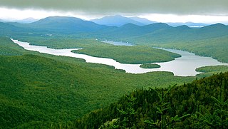
North Elba is a town in Essex County, New York, United States. The population was 7,480 at the 2020 census.

<span class="mw-page-title-main">St. Armand, New York</span> Town in New York, United States

St. Armand is a town in Essex County, New York, United States. The population was 1,446 at the 2020 census. The town was named by an early settler for Saint-Armand, Quebec, in Canada.

<span class="mw-page-title-main">Brighton, Franklin County, New York</span> Town in New York, United States

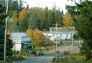
Brighton is a town in Franklin County, New York, United States. The population was 1,435 at the 2010 census. It was named after Brighton, England, by early surveyors in the region.

<span class="mw-page-title-main">Franklin, Franklin County, New York</span> Town in New York, United States

Franklin is a town located in Franklin County, New York, United States. As of the 2010 census, the town had a population of 1,140.

<span class="mw-page-title-main">Santa Clara, New York</span> Town in New York, United States

Santa Clara is a town in Franklin County, New York, United States. The population was 345 at the 2010 census. The name was derived from the wife of an early town businessman, John Hurd.

<span class="mw-page-title-main">Waverly, Franklin County, New York</span> Town in New York, United States

Waverly is a town in Franklin County, New York, United States. The population was 1,022 at the 2010 census. The town is on the western border of the county, southwest of Malone.

<span class="mw-page-title-main">Alexandria, New York</span> Town in New York, United States

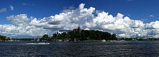
Alexandria is a town in the Thousand Islands region of the U.S. state of New York, within Jefferson County. The town's population was 3,741 at the 2020 United States Census. The town is named after Alexander LeRay, the son of an early developer. The village of Alexandria Bay is within the town.

<span class="mw-page-title-main">Hamlin, New York</span> Town in New York, United States

Hamlin is a town in Monroe County, New York, United States. The population was 8,725 at the 2020 census.

<span class="mw-page-title-main">Kirkland, New York</span> Town in Oneida County, New York, United States

Kirkland is a town in Oneida County, New York, United States. The population was 10,075 at the 2020 census. The town is named after Samuel Kirkland, a missionary among the Oneidas.

<span class="mw-page-title-main">Clifton, New York</span> Town in New York, United States

Clifton is a town in St. Lawrence County, New York, United States. The population was 675 at the 2020 census. The town takes its name from a mining company.

<span class="mw-page-title-main">Hopkinton, New York</span> Town in New York, United States

Hopkinton is a town in St. Lawrence County, New York, United States. The population was 1,105 at the 2020 census and has a Population density of 5.9 square miles. The town is named for Roswell Hopkins, a pioneer settler and a government official.

<span class="mw-page-title-main">Saranac Lake, New York</span> Village in New York, United States

Saranac Lake is a village in the state of New York, United States. As of the 2020 census, the population was 4,887, making it the largest community by population in the Adirondack Park. The village is named after Upper, Middle and Lower Saranac lakes, which are nearby.

<span class="mw-page-title-main">Dannemora, New York</span> Town in New York, United States

Dannemora is a town in Clinton County, New York, United States. The population was 4,037 at the 2020 census, down from 4,898 in 2010. The town is named after Dannemora, Sweden, an important iron-mining region.

<span class="mw-page-title-main">Plattsburgh (town), New York</span> Town in New York, United States

Plattsburgh is a town in Clinton County, New York, United States. The population was 11,886 at the 2020 census. The town is named after Zephaniah Platt, an early land owner, and it surrounds the separate and more populous city of the same name. The town is in the eastern part of the county, in the North Country region of the state of New York. The region's airport, Plattsburgh International Airport, is located in the southern part of the town.

<span class="mw-page-title-main">New York State Route 86</span> State highway in New York, US

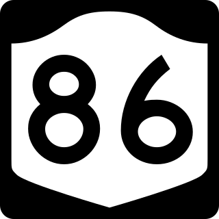
New York State Route 86 (NY 86) is a 39.11-mile (62.94 km) long state highway located within Adirondack Park in northern New York, in the United States, linking Franklin County to Essex County. The western terminus of the route is at NY 30 in the hamlet of Paul Smiths. The eastern terminus is at NY 9N in Jay. Although largely a two-lane road, NY 86 is one of only two east–west highways in the High Peaks area of the Adirondack Park, providing a major link between hamlets and tourist destinations.

References

  1. "2016 U.S. Gazetteer Files". United States Census Bureau. Retrieved July 5, 2017.
  2. U.S. Census Bureau, 2020 Report, Harrietstown, Franklin County, New York QuickFacts https://www.census.gov/quickfacts/harrietstowntownfranklincountynewyork
  3. "Geographic Identifiers: 2010 Census Summary File 1 (G001), Saranac Lake village (part), Harrietstown town, Franklin County, New York". American FactFinder. U.S. Census Bureau. Archived from the original on February 14, 2020. Retrieved June 13, 2016.
  4. "National Register Information System". National Register of Historic Places . National Park Service. July 9, 2010.
  5. "Geographic Identifiers: 2010 Census Summary File 1 (G001), Harrietstown town, Franklin County, New York". American FactFinder. U.S. Census Bureau. Archived from the original on February 13, 2020. Retrieved June 13, 2016.
  6. "Census of Population and Housing". Census.gov. Retrieved June 4, 2015.
  7. U.S. Census Bureau, 2020 Report, Harrietstown, Franklin County, New York QuickFacts https://www.census.gov/quickfacts/harrietstowntownfranklincountynewyork
  8. "U.S. Census website". United States Census Bureau . Retrieved January 31, 2008.

44°23′49″N74°09′31″W / 44.39694°N 74.15861°W / 44.39694; -74.15861