Related Research Articles

Chatham County is a county located in the Piedmont area of the U.S. state of North Carolina. It is also the location of the geographic center of North Carolina, northwest of Sanford. As of the 2020 census, the population was 76,285. Its county seat is Pittsboro.

Waynesville is the county seat of Haywood County, North Carolina. It is the largest town in North Carolina west of Asheville. Waynesville is located about 30 miles (50 km) southwest of Asheville between the Great Smoky and Blue Ridge Mountains.

Star is a town in Montgomery County, North Carolina, United States. The population was 876 at the 2010 census.
Cedar Creek may refer to:

The Cape Fear River is a 191.08-mile-long blackwater river in east-central North Carolina. It flows into the Atlantic Ocean near Cape Fear, from which it takes its name. The river is formed at the confluence of the Haw River and the Deep River in the town of Moncure, North Carolina. Its river basin is the largest in the state: 9,149 sq mi.

The Haw River is a tributary of the Cape Fear River, approximately 110 mi (177 km) long, that is entirely contained in north central North Carolina in the United States. It was first documented as the "Hau River" by John Lawson, an English botanist, in his 1709 book "A New Voyage to Carolina." The name is shortened from Saxapahaw, from the Catawban /sak'yápha:/, "piedmont, foothill", from /sak/, "hill", plus /yápha:/, "step". The river gives its name to a small town that formed on its banks.

Deep River is a tributary of the Cape Fear River, approximately 125 miles (201 km) long, in north central North Carolina in the United States. Deep River is a translation of the Indian name sapponah, "deep river".
Lockville is an unincorporated community located in southeastern Chatham County, North Carolina, United States, near the community of Moncure.

Carbonton is an unincorporated community in southwestern Chatham County, North Carolina, United States, along the Deep River. The community lies near the point where Chatham, Lee, and Moore counties intersect one another. The community derived its name from the local coal industry that thrived nearby until the early 20th century.
Corinth is an unincorporated community in Chatham County, North Carolina, United States. The community is located in the panhandle of Chatham County, southeast of Moncure. It was named in homage to the ancient Greek city of Corinth.
Gulf is an unincorporated community and census-designated place (CDP) in southwestern Chatham County, North Carolina, United States, southeast of the town of Goldston. As of the 2010 census, the Gulf CDP had a population of 144. The community is home to a general store and several historic homes. It received its name from its location at a wide bend in the Deep River.

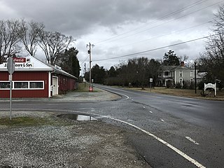
Moncure, founded in 1881, is a small rural unincorporated community in southeastern Chatham County, North Carolina, United States. Moncure and the neighboring community of Haywood form the Moncure census-designated place (CDP), which had a population of 711 at the 2010 census. The community is located near the confluence of the Deep and Haw rivers, which form the Cape Fear River. Moncure once served as the westernmost inland port in the state, linked to the Atlantic Ocean by steamships.

Brickhaven is an unincorporated community in southeastern Chatham County, North Carolina, United States, near the Harnett County line. It is located in the panhandle of Chatham County, southeast of Moncure and is near the community of Corinth. Its name derives from the numerous brick plants and clay pits located in the community.

Cape Fear is a coastal plain and Tidewater region of North Carolina centered about the city of Wilmington. The region takes its name from the adjacent Cape Fear headland, as does the Cape Fear River which flows through the region and empties into the Atlantic Ocean near the cape. Much of the region's populated areas are found along the Atlantic beaches and the Atlantic Intracoastal Waterway, while the rural areas are dominated by farms and swampland like that of the Green Swamp. The general area can be also identified by the titles "Lower Cape Fear", "Wilmington, NC Metropolitan Statistical Area", "Southeastern North Carolina", and "Azalea Coast". The latter name is derived from the North Carolina Azalea Festival held annually in Wilmington. Municipalities in the area belong to the Cape Fear Council of Governments.
Seminole is an unincorporated community located along U.S. Route 421 in the Upper Little River Township of Harnett County, North Carolina, United States, near the county line with Lee County just outside the town of Broadway. It is a part of the Dunn Micropolitan Area, which is also a part of the greater Raleigh–Durham–Cary Combined Statistical Area (CSA) as defined by the United States Census Bureau.
Deep River State Trail is a unit of the North Carolina state park system in Chatham, Lee, Moore, Randolph and Guilford Counties, North Carolina in the United States, and it covers 1,277 acres (517 ha) along the Deep River. The State Trail is planned as a combination hiking trail and paddle trail along the Deep River, from Jamestown to its confluence with the Cape Fear River. The park and trail were established by the General Assembly on August 2, 2007. The first land acquisition for the park is known as the "Justice Lands", which are near Jordan Lake. No part of the park is currently developed, and no trail segments have yet been designated by the North Carolina Division of Parks and Recreation.
Georges Creek may refer to:
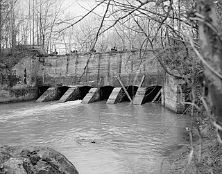
Lockville Dam, Canal and Powerhouse is a historic dam, canal, and powerhouse located near Moncure, Chatham County, North Carolina. The dam was built in 1922 and replaced an earlier log dam built by the Cape Fear and Deep River Navigation Company. The canal stone walls appear to date from the mid-1850s. The powerhouse was built in 1922, and is a simple brick and concrete structure resting on a massive stone foundation.
Shaddox Creek is a 3.83 mi (6.16 km) long 3rd order tributary to the Haw River in Chatham County, North Carolina. Shaddox Creek is the only stream of this name in the United States.

Cape Fear Township, population 1,323, is one of thirteen townships in Chatham County, North Carolina. Cape Fear Township is 54.26 square miles (140.5 km2) in size and located in southeast Chatham County. Cape Fear Township does not contain any municipalities within it, but does contain Moncure, a census designated place.
References
- ↑ "Haywood". Geographic Names Information System . United States Geological Survey, United States Department of the Interior . Retrieved December 5, 2014.
- 1 2 3 4 Daniels, Dennis (Spring 2005). "The Loss of a Town" (PDF). Tar Heel Junior Historian. North Carolina Museum of History. 44 (2). Archived from the original (PDF) on June 7, 2013. Retrieved December 5, 2014.
- ↑ Watson, Alan D. (2003). Wilmington, North Carolina, to 1861. Jefferson: McFarland & Company, Inc. pp. 213–214. ISBN 9780786482146.
- ↑ "National Register Information System". National Register of Historic Places . National Park Service. July 9, 2010.
Municipalities and communities of Chatham County, North Carolina, United States | ||
|---|---|---|
| Towns |  | |
| CDPs | ||
| Other communities | ||
| Footnotes | ‡This populated place also has portions in an adjacent county or counties | |