The Dale Hollow Reservoir is a reservoir situated on the Kentucky/Tennessee border. The lake is formed by the damming of the Obey River, 7.3 miles (11.7 km) above its juncture with the Cumberland River at river mile 380. Portions of the lake also cover the Wolf River. Dale Hollow is one of four major flood control reservoirs for the Cumberland; the others being Percy Priest Lake, Lake Cumberland, and Center Hill Lake. It is also the site of Dale Hollow Lake State Park on the north (Kentucky) side.
Fayette County Reservoir is a power station cooling reservoir on Cedar Creek in the Colorado River basin, 3 miles west of Fayetteville, Texas and 10 miles east of La Grange, Texas. The reservoir was created in 1978 when a dam was built on the creek to provide a cooling pond for the Fayette Power Project which provides electrical generation to Fayette County and surrounding areas. The dam, lake, and power plant are managed by the Lower Colorado River Authority. The lake is also used for recreational purposes, especially fishing.
Proctor Lake is a U.S. Army Corps of Engineers reservoir along the Leon River located in Comanche County in the U.S. state of Texas, around 3 miles (5 km) west of Proctor, Texas. Proctor Lake Dam and the reservoir are managed by the Fort Worth District of the U.S. Army Corps of Engineers. The reservoir was officially impounded in 1963, and serves to provide flood control and drinking water for the communities downstream. Proctor Lake is a popular recreational destination.

Carlyle Lake is a 25,000-acre (101.2 km2) reservoir largely located in Clinton County, Illinois, United States, with smaller portions of the lake within Bond and Fayette counties. It is the largest man-made lake in Illinois, and the largest lake wholly contained within the state.

Yellowstone Lake State Park is a state park of Wisconsin, United States, featuring a 455-acre (184 ha) reservoir on a tributary of the Pecatonica River. The state park is included in the 4,047-acre (1,638 ha) Yellowstone Lake State Wildlife Area. The park has 128 campsites and 5 group sites. There is a swimming area with sand beach, picnic areas, and playgrounds. Boat launch, boat rentals, fishing for bluegill, largemouth bass, walleye and channel catfish, with some northern pike and muskellunge. Hiking trails, and groomed cross country ski trails. The adjacent 4,000 acre wildlife area offers extensive horse trails and a shooting range.

Spruce Run Recreation Area is a 1,290-acre (5.2 km2) New Jersey state recreation area located in Union Township and Clinton Township in Hunterdon County, New Jersey, United States. It encompasses the Spruce Run Reservoir that is used as a backup reservoir to protect the state from prolonged droughts. The reservoir is the third largest in the state, after Round Valley and Wanaque Reservoir. The reservoir is used for recreation purposes, including hunting, fishing, boating and swimming.

The Tennessee Wildlife Resources Agency (TWRA) is an independent state agency of the state of Tennessee with the mission of managing the state's fish and wildlife and their habitats, as well as responsibility for all wildlife-related law enforcement activities. The agency also has responsibility for fostering the safe use of the state's waters through a program of law enforcement, education, and access.
Ramsey Lake State Recreation Area is a 1,980-acre (800 ha) state park located in Fayette County, Illinois, United States. The nearest town is Ramsey, Illinois, and the park is adjacent to U.S. Highway 51. The park is managed by the Illinois Department of Natural Resources (IDNR).
East Fork State Park is 4,870-acre (1,970 ha) public recreation area located around the East Fork of the Little Miami River in Clermont County, twenty miles (32 km) southeast of central Cincinnati, Ohio, in the United States. It maintains the 33-mile "Steve Newman World-Walker" perimeter trail, camping, hiking, swimming, and boating opportunities. The state park has hosted junior and collegiate rowing races, including the US Rowing Youth National Championships. The park's main feature is William H. Harsha Lake, a 2,107-acre (853 ha) reservoir created in 1978. The lake's large earthen dam and smaller saddle dams are operated by the U.S. Army Corps of Engineers.

Booker T. Washington State Park is a 353-acre (1.43 km2) park situated on the shores of Chickamauga Lake. It was built largely by African-American units of the Civilian Conservation Corps. It was originally designated under segregation as one of two Tennessee State Parks for use by blacks until discrimination in public accommodations in the United States was banned under the Civil Rights Act of 1964.

Senecaville Lake is a reservoir in Guernsey and Noble Counties, Ohio. It is located approximately 13 miles (21 km) southeast of Cambridge near the village of Senecaville, Ohio. The lake is popular among recreation and fishing enthusiasts. It is often referred to locally as Seneca Lake.
Lake Ovid is a reservoir located within Sleepy Hollow State Park, Michigan, created in the 1970s with the construction of a dam on the Little Maple River. With an average depth of 10 feet, Lake Ovid is generally fairly shallow, with depths never exceeding 23 feet.
Cherokee Lake, also known as Cherokee Reservoir, is an artificial reservoir in the U.S. state of Tennessee formed by the impoundment of the Holston River behind Cherokee Dam.

Pleasant Creek Wildlife Management Area is located near Philippi, West Virginia in Barbour and Taylor counties. Located on 3,030 acres (1,230 ha) land that varies from wetlands to steeply forested woodlands, the Pleasant Creek WMA rises to an elevation of 1,600 feet (490 m).
Plum Orchard Lake Wildlife Management Area, is located near Pax, West Virginia in Fayette county. Located on 3,201 acres (1,295 ha) land that varies from wetlands to steeply forested woodlands, the Pleasant Creek WMA rises to an elevation of 1,600 feet (490 m).
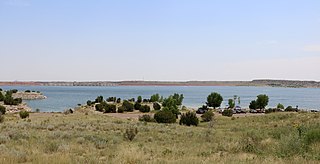
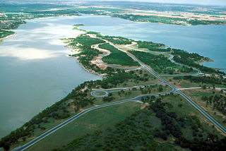
Lake Pueblo State Park is a state park located in Pueblo County, Colorado. It includes 60 miles (97 km) of shoreline and 10,000 acres (40 km2) of land. Activities it offers include two full-service marinas, recreational fishing, hiking, camping and swimming at a special swim beach.
Edward Medard Park and Preserve, originally known as Pleasant Grove Reservoir Park, is located south of Plant City, Florida, on Turkey Creek Road in Hillsborough County, Florida. The 1,284-acre (5.20 km2) park just north of Durant, Florida was the site of phosphate mining in the 1960s by the American Cyanamid Company, before the land was donated. A dike and 770-acre (3.1 km2) reservoir were created in 1970 to provide flood protection along the Alafia River. The lake has a very extensive and irregular shoreline, and great variation is found in the lake bottom as well. The park is maintained by the Hillsborough County Parks and Recreation Department, and has camping, picknicking, and other facilities. Three long piers offer the ability to launch fairly large vessels, although the lake has a no-wake restriction. Additional opportunities for various sports and aquatic activities are available at the popular spot which attracts approximately 250,000 visitors a year.
Piney Run Park is a nature park in Sykesville, located in Carroll County, Maryland. It is Carroll County's oldest developed park and hosts thousands of visitors annually. The park encompasses 550 acres of fields, forest and open spaces, features over 15 miles of hiking trails, a 300-acre lake and many sports and recreational facilities. Prior to being a park, this land was a private farm.
Kirby Lake is a 740-acre man-made reservoir located on the south side of Abilene, Texas, just east of Highway 83, in the northeastern portion of Taylor County. Kirby Lake is within the Brazos River Basin, meaning that Cedar Creek, which feeds Kirby Lake, eventually feeds into the Brazos River. Kirby Lake resides in the Red Prairies portion of the Central Great Plains ecoregion. Management is under the City of Abilene.
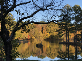
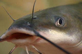
Lake Graham is a reservoir in Madison County, Tennessee 5 miles (8.0 km) west of the city of Jackson. It is primarily a recreational lake that also provides wetlands habitat to local wildlife and migratory birds. The lake is owned and managed by the Tennessee Wildlife Resources Agency (TWRA). The TWRA Region One offices are located at the lake, and it is the largest lake managed by the Agency. The lake is impounded by a 51 foot (16 m) high earthen dam with an uncontrolled spillway.