
Limestone is a type of carbonate sedimentary rock which is the main source of the material lime. It is composed mostly of the minerals calcite and aragonite, which are different crystal forms of CaCO3. Limestone forms when these minerals precipitate out of water containing dissolved calcium. This can take place through both biological and nonbiological processes, though biological processes, such as the accumulation of corals and shells in the sea, have likely been more important for the last 540 million years. Limestone often contains fossils which provide scientists with information on ancient environments and on the evolution of life.
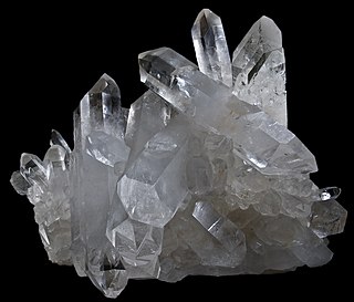
Quartz is a hard, crystalline mineral composed of silica (silicon dioxide). The atoms are linked in a continuous framework of SiO4 silicon–oxygen tetrahedra, with each oxygen being shared between two tetrahedra, giving an overall chemical formula of SiO2. Quartz is, therefore, classified structurally as a framework silicate mineral and compositionally as an oxide mineral. Quartz is the second most abundant mineral in Earth's continental crust, behind feldspar.

Celestine (the IMA-accepted name) or celestite is a mineral consisting of strontium sulfate (SrSO4). The mineral is named for its occasional delicate blue color. Celestine and the carbonate mineral strontianite are the principal sources of the element strontium, commonly used in fireworks and in various metal alloys.

Herkimer is a village on the north side of the Mohawk River and the county seat of Herkimer County, New York, United States, about 15 miles (24 km) southeast of Utica. As of the 2020 Census, it had a population of 7,234, and a predicted population of 7,283 on July 1, 2022. It was part of the Burnetsfield Patent and the first colonial settlement this far west in the Mohawk Valley.
The Llano Uplift is a geologically ancient, low geologic dome that is about 90 miles (140 km) in diameter and located mostly in Llano, Mason, San Saba, Gillespie, and Blanco counties, Texas. It consists of an island-like exposure of Precambrian igneous and metamorphic rocks surrounded by outcrops of Paleozoic and Cretaceous sedimentary strata. At their widest, the exposed Precambrian rocks extend about 65 miles (105 km) westward from the valley of the Colorado River and beneath a broad, gentle topographic basin drained by the Llano River. The subdued topographic basin is underlain by Precambrian rocks and bordered by a discontinuous rim of flat-topped hills. These hills are the dissected edge of the Edwards Plateau, which consist of overlying Cretaceous sedimentary strata. Within this basin and along its margin are down-faulted blocks and erosional remnants of Paleozoic strata which form prominent hills.

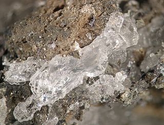
A geode is a geological secondary formation within sedimentary and volcanic rocks. Geodes are hollow, vaguely spherical rocks, in which masses of mineral matter are secluded. The crystals are formed by the filling of vesicles in volcanic and subvolcanic rocks by minerals deposited from hydrothermal fluids; or by the dissolution of syn-genetic concretions and partial filling by the same or other minerals precipitated from water, groundwater, or hydrothermal fluids.
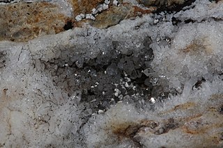
A vug, vugh, or vugg is a small- to medium-sized cavity inside rock. It may be formed through a variety of processes. Most commonly, cracks and fissures opened by tectonic activity are partially filled by quartz, calcite, and other secondary minerals. Open spaces within breccias formed by an ancient collapse are another important source of vugs.

Coesite is a form (polymorph) of silicon dioxide (SiO2) that is formed when very high pressure (2–3 gigapascals), and moderately high temperature (700 °C, 1,300 °F), are applied to quartz. Coesite was first synthesized by Loring Coes, Jr., a chemist at the Norton Company, in 1953.
Stishovite is an extremely hard, dense tetragonal form (polymorph) of silicon dioxide. It is very rare on the Earth's surface; however, it may be a predominant form of silicon dioxide in the Earth, especially in the lower mantle.

Carbonate rocks are a class of sedimentary rocks composed primarily of carbonate minerals. The two major types are limestone, which is composed of calcite or aragonite (different crystal forms of CaCO3), and dolomite rock (also known as dolostone), which is composed of mineral dolomite (CaMg(CO3)2). They are usually classified based on texture and grain size. Importantly, carbonate rocks can exist as metamorphic and igneous rocks, too. When recrystallized carbonate rocks are metamorphosed, marble is created. Rare igneous carbonate rocks even exist as intrusive carbonatites and, even rarer, there exists volcanic carbonate lava.

Larimar is the tradename for a rare blue variety of the silicate mineral pectolite found only in the Dominican Republic, around the city of Barahona. Its coloration varies from bluish white, light-blue, light-green, green-blue, turquoise blue, turquoise green, turquoise blue-green, deep green, dark green, to deep blue, dark blue and purple, violet and indigo and the larimar can come in many varieties and color mixes.
Evenkite is a rare hydrocarbon mineral with formula C24H50; specifically, H3C–(CH2)22–CH3, the alkane n-tetracosane. It occurs as very soft (Mohs hardness 1) transparent crystals, colorless to yellow, with a waxy luster. The softness is a characteristic of crystalline long-chain alkanes, which are the main constituents of paraffin wax.
Barringer Hill is a geological and mineralogical site in central Texas. It lies on the former west side of the Colorado River, beneath Lake Buchanan, about 22 miles (35 km) northeast of the town of Llano. The hill consists of a pegmatite and geologically, lies near the eastern edge of the Central Mineral Region in the Texas Hill Country. It is named for John Baringer, who discovered in it large amounts of gadolinite about 1887 (Hess).
A metamorphic facies is a set of mineral assemblages in metamorphic rocks formed under similar pressures and temperatures. The assemblage is typical of what is formed in conditions corresponding to an area on the two dimensional graph of temperature vs. pressure. Rocks which contain certain minerals can therefore be linked to certain tectonic settings, times and places in the geological history of the area. The boundaries between facies are wide because they are gradational and approximate. The area on the graph corresponding to rock formation at the lowest values of temperature and pressure is the range of formation of sedimentary rocks, as opposed to metamorphic rocks, in a process called diagenesis.

Except where underlain by the Sixtymile Formation, the Tapeats Sandstone is the Cambrian geologic formation that is the basal geologic unit of the Tonto Group. Typically, it is also the basal geologic formation of the Phanerozoic strata exposed in the Grand Canyon, Arizona, and parts of northern Arizona, central Arizona, southeast California, southern Nevada, and southeast Utah. The Tapeats Sandstone is about 230 feet (70 m) thick, at its maximum. The lower and middle sandstone beds of the Tapeats Sandstone are well-cemented, resistant to erosion, and form brownish, vertical cliffs that rise above the underlying Precambrian strata outcropping within Granite Gorge. They form the edge of the Tonto Platform. The upper beds of the Tapeats Sandstone form the surface of the Tonto Platform. The overlying soft shales and siltstones of the Bright Angel Shale underlie drab-greenish slopes that rise from the Tonto Platform to cliffs formed by limestones of the Muav Limestone and dolomites of the Frenchman Mountain Dolostone.
The Shady Dolomite is a geologic formation composed of marine sedimentary rocks of early Cambrian age. It outcrops along the eastern margin of the Blue Ridge province in the southeastern United States and can be found in outcrops in the states of Alabama, Georgia, Tennessee, North Carolina, and Virginia. It can also be found in the subsurface of Kentucky, Ohio, and West Virginia. The Shady is predominantly composed of dolomite and limestone with lesser amounts of mudrock. It contains fossils of trilobites, archaeocyathids, algae, brachiopods, and echinoderms, along with the enigmatic fossil Salterella. The Shady Dolomite was first described by Arthur Keith in 1903 and was named for exposures in the Shady Valley of Johnson County in the state of Tennessee. Near Austinville, Virginia, the Shady hosts ore deposits that have been mined extensively for lead and zinc ore.

The Little Falls Formation or Little Falls Dolostone is a geologic formation in New York. The unit is of Cambrian age and rests unconformably on Precambrian rock. The unit is noted as the host for the Herkimer diamonds of New York. The unit contains stromatolites and rare brachiopod fossils.
The geochemistry of carbon is the study of the transformations involving the element carbon within the systems of the Earth. To a large extent this study is organic geochemistry, but it also includes the very important carbon dioxide. Carbon is transformed by life, and moves between the major phases of the Earth, including the water bodies, atmosphere, and the rocky parts. Carbon is important in the formation of organic mineral deposits, such as coal, petroleum or natural gas. Most carbon is cycled through the atmosphere into living organisms and then respirated back into the atmosphere. However an important part of the carbon cycle involves the trapping of living matter into sediments. The carbon then becomes part of a sedimentary rock when lithification happens. Human technology or natural processes such as weathering, or underground life or water can return the carbon from sedimentary rocks to the atmosphere. From that point it can be transformed in the rock cycle into metamorphic rocks, or melted into igneous rocks. Carbon can return to the surface of the Earth by volcanoes or via uplift in tectonic processes. Carbon is returned to the atmosphere via volcanic gases. Carbon undergoes transformation in the mantle under pressure to diamond and other minerals, and also exists in the Earth's outer core in solution with iron, and may also be present in the inner core.

The Durness Group is a geological group, a carbonate-dominated stratigraphic unit that forms a c. 170 km long narrow and discontinuous outcrop belt along the north-western coast of Scotland from the Isle of Skye and Loch Kishorn in the south to Durness and Loch Eriboll in the north. It forms the youngest part of the foreland basin of the Moine Thrust Belt in the Scottish Northwest Highlands and is incorporated into this belt's lowermost thrust sheets, where it is often affected by thrust faulting. It overlies the Ardvreck Group.

Queitite is a lead zinc silicate sulphate that was named after the mineral dealer Clive S. Queit, who collected the first specimens. It got approved by the IMA in 1979, and it is an extremely rare secondary mineral.
