
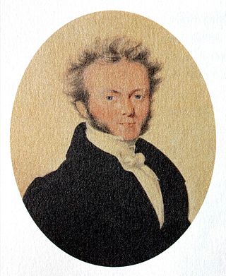
Sir John Frederick William Herschel, 1st Baronet was an English polymath active as a mathematician, astronomer, chemist, inventor, experimental photographer who invented the blueprint and did botanical work.
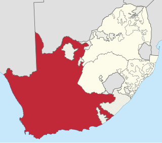
The Province of the Cape of Good Hope, commonly referred to as the Cape Province and colloquially as The Cape, was a province in the Union of South Africa and subsequently the Republic of South Africa. It encompassed the old Cape Colony, as well as Walvis Bay, and had Cape Town as its capital. In 1994, the Cape Province was divided into the new Eastern Cape, Northern Cape and Western Cape provinces, along with part of the North West.
Herschel or Herschell may refer to:

Port Alfred is a small town with a population of just under 26,000 in the Eastern Cape province of South Africa. It is situated on the eastern seaboard of the country at the mouth of the Kowie River, almost exactly halfway between the larger cities of Gqeberha and East London and 30 kilometres (19 mi) west of Cannon Rocks.

Wynberg is a southern suburb of the City of Cape Town in Western Cape, South Africa. It is situated between Plumstead and Kenilworth, and is a main transport hub for the Southern Suburbs of Cape Town.
Sir Thomas Maclear was an Irish-born South African astronomer who became Her Majesty's astronomer at the Cape of Good Hope.
The Grove Primary School is a school from pre-primary to Grade 7 in Claremont, Cape Town, Western Cape, South Africa.

Herschel Girls School is a private, weekly boarding and day school for girls, located in Claremont, a southern suburb of Cape Town, Western Cape, South Africa. The school has pre-nursery through to grade 12 and is affiliated with the Anglican church, which owns the school buildings.

The Southern Suburbs are a group of Anglophone suburbs in Cape Town, Western Cape, South Africa. This group includes, among others, Observatory, Mowbray, Pinelands, Rosebank, Rondebosch, Rondebosch East, Newlands, Claremont,Lansdowne, Kenilworth, Bishopscourt, Constantia, Wynberg, Ottery, Plumstead, Diep River, Bergvliet and Tokai. The area is also commonly referred to as the Cape Peninsula, often including the towns further South such as Fish Hoek.

The Diocese of Cape Town is a diocese of the Anglican Church of Southern Africa (ACSA) which presently covers central Cape Town, some of its suburbs and the island of Tristan da Cunha, though in the past it has covered a much larger territory. The Ordinary of the diocese is Archbishop of Cape Town and ex officio Primate and Metropolitan of the ACSA. His seat is St. George's Cathedral in Cape Town.
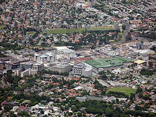
Claremont is a suburb of Cape Town, South Africa. It is situated 9 kilometres south of the city, and is one of the so-called "Southern Suburbs", it is situated alongside Lansdowne. It is an important commercial and residential area, which is currently experiencing significant growth and development.

The Most Reverend William Marlborough Carter, (1850–1941) was an Anglican bishop and archbishop in South Africa.
Bothasig is a suburban area of the City of Cape Town in Western Cape, South Africa. It is located north of Edgemead and east of Milnerton. It is located approximately 15 km north-east of the Cape Town city centre.

Cape Sterneck is a bold, black cliff on a projecting point forming the west extremity of Chavdar Peninsula on the west coast of Graham Land, Antarctica. It is situated on the north side of the entrance to Hughes Bay and the west side of the entrance to Curtiss Bay, and separating Davis Coast to the northeast from Danco Coast to the southwest.
Tentergate is a town in Chris Hani District Municipality in the Eastern Cape province of South Africa.
Da Gama Park is a suburb of the City of Cape Town in the Western Cape province of South Africa.
Colonel John Herschel was an English military engineer, surveyor and astronomer. He was the son of Sir John Herschel, 1st Baronet, and grandson of William Herschel.
Sada is a semi-rural settlement, situated 3 km away from Whittlesea, 30 km north of Seymour and 40 km south of Queenstown, Eastern Cape Province. The word Sada means "finally" or "at last" in isiXhosa because the first settlers struggled to find a place before they settled in the area in 1964.
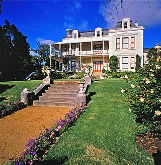
Hawthorndon House is a double-storeyed house on Herschel Walk in the suburb of Wynberg in Cape Town, South Africa. The house likely dates from 1683, but was substantially rebuilt in the French Victorian style in 1881 by a Capt. John Spence. It was bought by the Randlord Sir J.B. Robinson in 1891 and was where he lived until his death in 1927. Count Natale Labia, grandson of J.B. Robinson, donated Hawthornden to what is now the Government of the Western Cape Province in 1978, but will continue to live there during his lifetime.
Wanderers View is a suburb of Johannesburg, South Africa, about 1.2 km north of City Hall.


