South Africa occupies the southern tip of Africa, its coastline stretching more than 2,850 kilometres from the desert border with Namibia on the Atlantic (western) coast southwards around the tip of Africa and then northeast to the border with Mozambique on the Indian (eastern) coast. The low-lying coastal zone is narrow for much of that distance, soon giving way to a mountainous escarpment that separates the coast from the high inland plateau. In some places, notably the province of KwaZulu-Natal in the east, a greater distance separates the coast from the escarpment. Although much of the country is classified as semi-arid, it has considerable variation in climate as well as topography. The total land area is 1,220,813 km2 (471,359 sq mi). It has the 23rd largest Exclusive Economic Zone of 1,535,538 km2 (592,875 sq mi).

KwaZulu-Natal is a province of South Africa that was created in 1994 when the Zulu bantustan of KwaZulu and Natal Province were merged. It is located in the southeast of the country, with a long shoreline on the Indian Ocean and sharing borders with three other provinces and the countries of Mozambique, Eswatini and Lesotho. Its capital is Pietermaritzburg, and its largest city is Durban. It is the second-most populous province in South Africa, with slightly fewer residents than Gauteng.

The Drakensberg is the eastern portion of the Great Escarpment, which encloses the central Southern African plateau. The Great Escarpment reaches its greatest elevation – 2,000 to 3,482 metres within the border region of South Africa and Lesotho.

Veld, also spelled veldt, is a type of wide open rural landscape in Southern Africa. Particularly, it is a flat area covered in grass or low scrub, especially in the countries of South Africa, Lesotho, Eswatini, Zimbabwe and Botswana. A certain sub-tropical woodland ecoregion of Southern Africa has been officially defined as the Bushveld by the World Wide Fund for Nature. Trees are not abundant—frost, fire and grazing animals allow grass to grow but prevent the build-up of dense foliage.

Mokhotlong is a constituency, city and seat of Mokhotlong District in the mountainous northeastern part of Lesotho. It is the first major city with an airport along the road from South Africa across the Sani Pass, near the Maloti Mountains. The name of the city is a word in Sesotho, the language of the people of Lesotho, meaning "Place of the Bald Ibis." Thabana Ntlenyana, the highest point in southern Africa, is found in Mokhotlong.

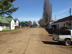
Himeville is a small village/town situated in the foothills of the picturesque Southern Drakensberg, KwaZulu-Natal, South Africa, approx 130 km from Pietermaritzburg. It is a landmark en route to the world-famous Sani Pass and the uKhahlamba Drakensberg Park. Himeville is the closest town to the Sani Pass which links the town with Mokhotlong in Lesotho.
Harrismith is a large town in the Free State province of South Africa. It was named for Sir Harry Smith, a 19th-century British governor and high commissioner of the Cape Colony. It is situated by the Wilge River, alongside the N3 highway, about midway between Johannesburg, about 275 km to the north-west, and Durban to the southeast. The town is located at the junction of the N5 highway, which continues westward towards the provincial capital Bloemfontein, some 340 km to the south-west. This important crossroads in South Africa's land trade routes is surrounded by mesas and buttes. It is located at the base of one of these called Platberg.

Rouxville is a small wool and cattle farming town in the Free State province of South Africa and is situated on the N6 national route. The town is at the centre of the wool producing area of the Transgariep.

Smithfield is a small town in the Free State province of South Africa. Founded in 1848 in the Orange River Sovereignty, the town is situated in a rural farming district and is the third oldest town in present-day Free State, after Philippolis and Winburg.

The Highveld is the portion of the South African inland plateau which has an altitude above roughly 1500 m, but below 2100 m, thus excluding the Lesotho mountain regions to the south-east of the Highveld. It is home to some of the country's most important commercial farming areas, as well as its largest concentration of metropolitan centres, especially the Gauteng conurbation, which accommodates one-third of South Africa's population.

Barkly East is a town in Eastern Cape Province, South Africa, seat of the Joe Gqabi District Municipality, and 117 km by road E.S.E. of Aliwal North, lying in the mountainous area just south of Lesotho. The town lies at the southern tip of the Drakensberg on the Langkloofspruit, a tributary of the Kraai River which, in turn is a tributary of the Orange River at an elevation of 1 790 meter above sealevel. Barkly East is characterized by rugged mountains and green valleys. Snow falls in winter, and the hamlet of Rhodes is 60 km or an hour's drive from Barkly East on the R396. Both are within the boundaries of the Senqu Local Municipality.

Sani Pass is a mountain pass located in the West of KwaZulu-Natal, South Africa on the road between Himeville, KwaZulu-Natal and Mokhotlong, Lesotho. The pass traverses the Great Escarpment of southern Africa in its highest region, the Drakensberg Mountains, which reach an elevation of over 3,000 meters.

The Karoo Supergroup is the most widespread stratigraphic unit in Africa south of the Kalahari Desert. The supergroup consists of a sequence of units, mostly of nonmarine origin, deposited between the Late Carboniferous and Early Jurassic, a period of about 120 million years.

The Great Escarpment is a major topographical feature in Africa that consists of steep slopes from the high central Southern African plateau downward in the direction of the oceans that surround southern Africa on three sides. While it lies predominantly within the borders of South Africa, in the east the escarpment extends northward to form the border between Mozambique and Zimbabwe, continuing on beyond the Zambezi river valley to form the Muchinga Escarpment in eastern Zambia. In the west, it extends northward into Namibia and Angola. It is the combination of this escarpment and the aridity of Southern Africa that leads to the lack of navigable rivers in South Africa.

Golden Gate Highlands National Park is located in Free State, South Africa, near the Lesotho border. It covers an area of 340 km2 (130 sq mi). The park's most notable features are its golden, ochre, and orange-hued, deeply eroded sandstone cliffs and outcrops, especially the Brandwag rock. Another feature of the area is the numerous caves and shelters displaying San rock paintings. Wildlife featured at the park includes mongooses, eland, zebras, and over 100 bird species. It is the Free State's only national park and is more famous for the beauty of its landscape than for its wildlife. Numerous palaeontology finds have been made in the park, including dinosaur eggs and skeletons.
The Sneeuberge or Sneeuberg mountain range was historically known as “Sneeuwbergen”, meaning ‘snow mountains’ in Cape Dutch, and refers to a significant portion of Southern Africa's Great Escarpment in the Cradock, Murraysburg, Richmond, Graaff-Reinet, Nieu-Bethesda and Middelburg districts of the Great Karoo, most of which are in the Eastern Cape Province.

Kaapschehoop or Kaapsehoop is a village situated in Mpumalanga province of South Africa.
The Bell River is a river that drains the Drakensberg uplands of the Eastern Cape province of South Africa. Its drainage basin, a part of the headwaters of the Orange River, is approximately 424 square kilometres (160 sq mi) in extent, ranging from an altitude of 1,720 m (a.m.s.l.) to 3,001 m. The river's source is near the Lesotho border to the north of the high Naude's Neck Pass. Downstream it passes the town of Rhodes, to eventually form a tributary of the Kraai River some 40 km (direct) from its source. In fact the Bell River and the Sterkspruit, become the Kraai River just northwest of Moshesh's Ford flowing further west towards Aliwal North, where it joins the Orange River.

Matatiele Municipality is a local municipality within the Alfred Nzo District Municipality, in the Eastern Cape province of South Africa. It adjoins Lesotho to the north, Elundini to the south-west, and Greater Kokstad to the east and its 4,352 km² makes the Matatiele Municipality largest of four municipalities in the district at almost half of its geographical area. According to the South African National Census of 2011, its 203,483 residents and 49,527 households makes Matatiele Municipality the second largest populated area in the Alfred Nzo District Municipality behind Mbizana.

Ts'ehlanyane National Park is a National Park in Lesotho. It is located in the Maloti Mountains in Leribe District, and is part of the larger Maloti-Drakensberg Transfrontier Conservation Area. This Lesotho northern park protects a high-altitude, 2,600-metre (8,500 ft) patch of rugged wilderness, including one of Lesotho’s only stands of indigenous forest with a number of rare undergrowth plants that are unique to this woodland habitat.