Hibbing, Minnesota

Last updated

Hibbing
East Howard St Commercial HD.jpg
East Howard Street in Hibbing
Motto: 
We're Ore And More. [1]
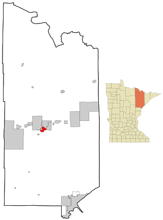
St. Louis County Minnesota Incorporated and Unincorporated areas Hibbing Highlighted.svg
Location of the city of Hibbing
within Saint Louis County, Minnesota
Coordinates: 47°25′2″N92°56′18″W / 47.41722°N 92.93833°W / 47.41722; -92.93833
CountryUnited States
State Minnesota
County Saint Louis
Founded1893
Government
   Mayor Pete Hyduke
Area
[2]
  Total186.46 sq mi (482.93 km2)
  Land182.03 sq mi (471.45 km2)
  Water4.43 sq mi (11.48 km2)
Elevation
[3]
1,490 ft (454 m)
Population
 (2020) [4]
  Total16,214
  Estimate 
(2022) [5]
16,052
  Density89.07/sq mi (34.39/km2)
Time zone UTC–6 (Central (CST))
  Summer (DST) UTC–5 (CDT)
ZIP code
55746
Area code 218
FIPS code 27-28790
GNIS feature ID0661469 [3]
Sales tax 7.375% [6]
Website hibbingmn.gov

Hibbing is a city in Saint Louis County, Minnesota, United States. The population was 16,214 at the 2020 census. [4] The city was built on mining the rich iron ore of the Mesabi Iron Range and still relies on that industrial activity today. At the edge of town is the world's largest open-pit iron mine, the Hull–Rust–Mahoning Open Pit Iron Mine. [7] It is the hometown of singer-songwriter Bob Dylan [8] and former Governor of Minnesota Rudy Perpich.

Contents

The main routes in Hibbing are U.S. Highway 169, State Highway 37, State Highway 73, Howard Street, and 1st Avenue. It is about 59 miles (95 km) northwest of Duluth, Minnesota.

History

The town was founded in 1893 by Frank Hibbing, [9] born in Walsrode, Germany on December 1, 1856, and christened Franz Dietrich von Ahlen. His mother died when he was still in infancy and it was her name, Hibbing, which he assumed when he set out to seek his fortune in the New World. He first settled in Beaver Dam, Wisconsin, where he worked on a farm and in a shingle mill. Injured in a mill accident, he considered becoming a lawyer, but after deciding he was not familiar enough with the English language to make a legal career possible, he turned to timber cruising.

In 1887, Hibbing settled in Duluth where he established a real estate business and began explorations on the Vermilion Range. In 1892, he headed a party of thirty men at Mountain Iron and cut a road through the wilderness to Section 22, 58–20. An expert iron ore prospector, he soon discovered the surface indication which led him to believe in the existence of extensive ore deposits.

In July 1893, the townsite of Hibbing was laid out and named in honor of him. Feeling personally responsible, he took the deepest pride in its development and, by his generous aid, made its progress possible. He used his personal means to provide a water plant, electric light plant, the first roads, hotel, sawmill, and bank building. For the last ten years of his life, Hibbing made his home in Duluth, where many of his business interests were centered. He retained close contact with the community which bore his name, until he died of appendicitis on July 30, 1897, at age forty.

In 1914, two men, Carl Wickman and Andrew "Bus Andy" Anderson, started a bus line between Hibbing and Alice, Minnesota, which would eventually become Greyhound Lines, the world's largest bus transportation company.

Hibbing Heights was platted in 1908 and annexed by Alice in 1910, when Alice incorporated as a city. Between 1919 and 1921, the Village of Hibbing was moved immediately south of Alice and then annexed Alice in 1920. Hibbing remained a village until 1979 when the Town of Stuntz was annexed. An Article of Incorporation was filed in July 1979 with the state and Hibbing became a city from that action in January 1980.

Hibbing is home to the world's largest iron ore mine, which was discovered by Leonidas Merritt. Hibbing grew rapidly in its early years as the huge iron ore mines such as the Mahoning, Hull, Rust, Sellers, and Burt provided the raw material for America's industrial revolution. In fact, the mines encroached on the village from the east, north, and west and it was determined that some of the ore body actually went under the town whose population had hit 20,000 by 1915.

Negotiations between the Oliver Mining Company and the village finally brought about a plan whereby the entire village would relocate to a site two miles south near Alice. The company, for its part, agreed to develop the downtown buildings with low interest loans that could be paid off over the years by the retailers. New civic structures such as Hibbing High School, the Androy Hotel, the Village Hall, and the Rood Hospital were also constructed with mining company money. In all, about 200 structures were moved down the First Avenue Highway, as it was called, to the new city. These included a store and even a couple of large hotels. Only one structure did not make it: the Sellers Hotel tumbled off some rollers and crashed to the ground leaving, as one witness said, "an enormous pile of kindling". The move started in 1919 and the first phase was completed in 1921. Known today as "North Hibbing", this area remained as a business and residential center through the 1940s when the mining companies bought the remaining structures. The last house was moved in 1968. [10]

On July 25, 1979, Hibbing annexed the Town of Stuntz which comprised five townships. With this annexation, the following unincorporated communities were also annexed (community location by township, range and section indicated):

On December 1, 1993, Northwest Airlink Flight 5719 crashed near Hibbing, killing all 18 people on board. [11]

Geography

According to the United States Census Bureau, the city has a total area of 186.46 square miles (482.9 km2), of which 182.03 square miles (471.5 km2) is land and 4.43 square miles (11.5 km2) is water. [12] McCarthy Beach State Park is nearby.

The Northern Divide intersects the St. Lawrence Divide near Hibbing, with waters draining to the Arctic Ocean, the Gulf of Mexico and the Great Lakes. [13]

Climate

Hibbing has a humid continental climate (Köppen climate classification: Dwb), experiencing all four seasons, but with long, drawn out winters. Summers are generally warm to hot, while winters are generally cold to severely cold. A freeze has been recorded for every month of the year.

Climate data for Hibbing, Minnesota (Chisholm-Hibbing Airport), 1991–2020 normals, [lower-alpha 1] extremes 1938–present
MonthJanFebMarAprMayJunJulAugSepOctNovDecYear
Record high °F (°C)51
(11)
60
(16)
80
(27)
89
(32)
95
(35)
97
(36)
98
(37)
95
(35)
95
(35)
87
(31)
72
(22)
60
(16)
98
(37)
Mean maximum °F (°C)38.0
(3.3)
43.8
(6.6)
57.5
(14.2)
72.6
(22.6)
83.6
(28.7)
87.1
(30.6)
88.7
(31.5)
87.2
(30.7)
83.2
(28.4)
74.8
(23.8)
54.6
(12.6)
40.1
(4.5)
90.4
(32.4)
Mean daily maximum °F (°C)16.9
(−8.4)
22.5
(−5.3)
35.4
(1.9)
49.5
(9.7)
63.4
(17.4)
72.2
(22.3)
76.7
(24.8)
74.9
(23.8)
65.7
(18.7)
50.8
(10.4)
34.3
(1.3)
21.4
(−5.9)
48.6
(9.2)
Daily mean °F (°C)6.2
(−14.3)
10.5
(−11.9)
23.8
(−4.6)
37.1
(2.8)
49.5
(9.7)
58.9
(14.9)
63.5
(17.5)
61.6
(16.4)
53.0
(11.7)
40.2
(4.6)
25.6
(−3.6)
12.3
(−10.9)
36.9
(2.7)
Mean daily minimum °F (°C)−4.4
(−20.2)
−1.4
(−18.6)
12.2
(−11.0)
24.8
(−4.0)
35.7
(2.1)
45.7
(7.6)
50.3
(10.2)
48.3
(9.1)
40.3
(4.6)
29.7
(−1.3)
16.9
(−8.4)
3.1
(−16.1)
25.1
(−3.8)
Mean minimum °F (°C)−29
(−34)
−25.2
(−31.8)
−14.2
(−25.7)
10.6
(−11.9)
23.4
(−4.8)
32.2
(0.1)
39.0
(3.9)
36.7
(2.6)
25.8
(−3.4)
16.2
(−8.8)
−3.6
(−19.8)
−22.2
(−30.1)
−32.5
(−35.8)
Record low °F (°C)−50
(−46)
−44
(−42)
−37
(−38)
−6
(−21)
14
(−10)
25
(−4)
32
(0)
27
(−3)
20
(−7)
0
(−18)
−27
(−33)
−38
(−39)
−50
(−46)
Average precipitation inches (mm)0.51
(13)
0.53
(13)
0.91
(23)
1.61
(41)
2.76
(70)
4.36
(111)
3.85
(98)
3.09
(78)
3.06
(78)
2.35
(60)
1.09
(28)
0.64
(16)
24.76
(629)
Average snowfall inches (cm)15.0
(38)
7.1
(18)
7.8
(20)
3.7
(9.4)
0.0
(0.0)
0.0
(0.0)
0.0
(0.0)
0.0
(0.0)
0.0
(0.0)
1.2
(3.0)
13.2
(34)
12.3
(31)
60.3
(153)
Average precipitation days (≥ 0.01 in)7.25.06.48.112.013.111.510.712.011.18.07.8112.9
Average snowy days (≥ 0.1 in)10.96.95.93.00.20.00.00.00.11.57.310.646.4
Source: NOAA (snow 1981–2010) [14] [15] [16]

Demographics

Historical population
CensusPop.Note
1900 2,481
1910 8,832256.0%
1920 15,08970.8%
1930 15,6663.8%
1940 16,3854.6%
1950 16,276−0.7%
1960 17,7318.9%
1970 20,74417.0%
1980 21,1932.2%
1990 18,046−14.8%
2000 17,071−5.4%
2010 16,361−4.2%
2020 16,214−0.9%
2022 (est.)16,052 [5] −1.0%
U.S. Decennial Census [17]
2020 Census [4]

2020 census

As of the census of 2020, [18] the population was 16,214. The population density was 89.1 inhabitants per square mile (34.4/km2). There were 8,302 housing units at an average density of 45.6 per square mile (17.6/km2). The racial makeup of the city was 91.3% White, 1.5% Black or African American, 0.9% Native American, 0.5% Asian, 0.1% Pacific Islander, 0.4% from other races, and 5.4% from two or more races. Ethnically, the population was 1.6% Hispanic or Latino of any race.

2010 census

As of the census of 2010, there were 16,361 people, 7,414 households, and 4,325 families living in the city. The population density was 90.0 inhabitants per square mile (34.7/km2). There were 8,200 housing units at an average density of 45.1 per square mile (17.4/km2). The racial makeup of the city was 95.9% White, 0.6% African American, 0.9% Native American, 0.4% Asian, 0.3% from other races, and 1.9% from two or more races. Hispanic or Latino of any race were 1.1% of the population.

There were 7,414 households, of which 26.3% had children under the age of 18 living with them, 42.5% were married couples living together, 11.1% had a female householder with no husband present, 4.8% had a male householder with no wife present, and 41.7% were non-families. 36.4% of all households were made up of individuals, and 14.8% had someone living alone who was 65 years of age or older. The average household size was 2.17 and the average family size was 2.80.

The median age in the city was 42.5 years. 21.6% of residents were under the age of 18; 8.6% were between the ages of 18 and 24; 22.7% were from 25 to 44; 29.4% were from 45 to 64; and 17.8% were 65 years of age or older. The gender makeup of the city was 48.4% male and 51.6% female.

2000 census

As of the census of 2000, there were 17,071 people, 7,439 households, and 4,597 families living in the city. The population density was 94.0 inhabitants per square mile (36.3/km2). There were 8,037 housing units at an average density of 44.2 per square mile (17.1/km2). The racial makeup of the city was 97.33% White, 0.46% Black, 0.73% Native American, 0.27% Asian, 0.01% Pacific Islander, 0.19% from other races, and 1.01% from two or more races. Hispanic or Latino of any race were 0.68% of the population. 17.1% were of German, 12.4% Finnish, 10.5% Norwegian, 9.4% Italian, 6.4% Irish and 5.9% Swedish ancestry.

There were 7,439 households, out of which 27.7% had children under the age of 18 living with them, 48.3% were married couples living together, 9.6% had a female householder with no husband present, and 38.2% were non-families. 33.5% of all households were made up of individuals, and 15.5% had someone living alone who was 65 years of age or older. The average household size was 2.24 and the average family size was 2.86.

In the city, the population was spread out, with 22.8% under the age of 18, 9.1% from 18 to 24, 24.5% from 25 to 44, 23.8% from 45 to 64, and 19.8% who were 65 years of age or older. The median age was 41 years. For every 100 females, there were 93.1 males. For every 100 females age 18 and over, there were 89.4 males.

The median income for a household in the city was $33,346, and the median income for a family was $43,558. Males had a median income of $38,064 versus $22,183 for females. The per capita income for the city was $18,561. About 8.1% of families and 11.7% of the population were below the poverty line, including 16.3% of those under age 18 and 8.2% of those age 65 or over.

Government

Presidential election results
Precinct General Election Results [19]
Year Republican Democratic Third parties
2020 49.7%4,26646.7% 4,0943.6% 216
2016 46.3%3,68146.3% 3,6747.4% 587
2012 33.4% 2,86364.0%5,4182.6% 179
2008 33.4% 2,91464.6%5,6292.0% 171
2004 31.9% 2,92467.1%6,1541.0% 87
2000 32.0% 2,72662.0%5,2776.0% 515
1996 24.6% 2,00063.2%5,13612.2% 996
1992 20.7% 1,93659.2%5,54820.1% 1,880
1988 30.5% 2,85369.5%6,4980.0% 0
1984 30.3% 3,00069.7%6,8940.0% 0
1980 28.6% 3,11963.7%6,9627.7% 846
1976 30.7% 2,90967.2%6,3552.1% 198
1968 26.4% 2,28271.0%6,1312.6% 224
1964 26.5% 2,28373.4%6,3260.1% 12
1960 35.8% 3,29964.0%5,9080.2% 21

Education

Hibbing is home to Hibbing Community College, a two-year community and technical college.

Media

AM

FM

TV

Newspapers

The Hibbing Daily Tribune newspaper was founded in Hibbing in 1893 and served readers in Saint Louis County. In 2020 it was combined with the Mesabi Daily News to create the Mesabi Tribune., of Virginia, Minnesota. The Mesabi is also owned by Adams Publishing Group. It is published daily, except Monday, with a circulation of 3,749 in 2019. The newspaper is currently owned by the Adams Publishing Group. [20]

Notable people

Bob Dylan's boyhood home in Hibbing ZimmermanHouseHibbingMN.jpg
Bob Dylan's boyhood home in Hibbing

Hibbing is the city where the character "Connie" tells Flamarion where she supposedly is going to for three months in the film The Great Flamarion.

Hibbing is featured as a setting for two episodes of the fantasy horror television series, Supernatural .

Both Bazooka and Tripwire, fictional G.I. Joe characters, were born in Hibbing.

Michael York's character in the comedy film, ''Wrongfully Accused'' , was named Hibbing Goodhue. Many of the characters names are based on cities in Minnesota.

Sister cities

Notes

  1. Mean monthly maxima and minima (i.e. the expected highest and lowest temperature readings at any point during the year or given month) calculated based on data at said location from 1981 to 2010.

Related Research Articles

<span class="mw-page-title-main">St. Louis County, Minnesota</span> County in Minnesota, United States

St. Louis County is a county located in the Arrowhead Region of the U.S. state of Minnesota. As of the 2020 census, the population was 200,231. Its county seat is Duluth. It is the largest county in Minnesota by land area, and the largest in the United States by total area east of the Mississippi River. St. Louis County is included in the Duluth, MN–Superior, WI Metropolitan Statistical Area.

<span class="mw-page-title-main">Lake County, Minnesota</span> County in Minnesota, United States

Lake County is a county in the U.S. state of Minnesota. As of the 2020 census, the population was 10,905. Its county seat is Two Harbors.

<span class="mw-page-title-main">Albert Lea, Minnesota</span> City in Minnesota, United States

Albert Lea is a city in Freeborn County, in southern Minnesota. It is the county seat. Its population was 18,492 at the 2020 census.

<span class="mw-page-title-main">Grand Rapids, Minnesota</span> City in Minnesota, United States

Grand Rapids is a city in Itasca County, Minnesota, United States, and it is the county seat. The population was 11,126 at the 2020 census. The city is named for the 3.5-mile (5.6 km) long rapids in the Mississippi River which was the uppermost limit of practical steamboat travel during the late 19th century. Today the rapids are hidden below the dam of UPM Paper Company.

<span class="mw-page-title-main">Silver Bay, Minnesota</span> City in Minnesota, United States

Silver Bay is a city in Lake County, Minnesota, United States. The population was 1,857 at the time of the 2020 census. It is the largest population center in a natural tourism area which includes, Tettegouche State Park and the Split Rock Lighthouse. It is a port along Lake Superior for iron ore and has taconite mining facilities of its own.

<span class="mw-page-title-main">Roseau, Minnesota</span> City in Minnesota, United States

Roseau is a city in, and the county seat of, Roseau County, Minnesota. Its population was 2,744 at the time of the 2020 census.

<span class="mw-page-title-main">Aurora, Minnesota</span> City in Minnesota, United States

Aurora is a city in Saint Louis County, Minnesota, United States. The population was 1,678 at the 2020 census.

<span class="mw-page-title-main">Babbitt, Minnesota</span> City in Minnesota, United States

Babbitt is a city in Saint Louis County, Minnesota, United States. The population was 1,397 at the 2020 census.

<span class="mw-page-title-main">Biwabik, Minnesota</span> City in Minnesota, United States

Biwabik is a city in Saint Louis County, Minnesota, United States. The population was 961 at the 2020 census.

<span class="mw-page-title-main">Chisholm, Minnesota</span> City in Minnesota, United States

Chisholm is a city in St. Louis County, Minnesota, United States. The population was 4,976 at the 2010 census. The city has been called "The Heart of the Iron Range" due to its location in the middle of the Mesabi Iron Range.

<span class="mw-page-title-main">Ely, Minnesota</span> City in Minnesota, United States

Ely is a city in Saint Louis County, Minnesota, United States. The population was 3,268 at the 2020 census.

<span class="mw-page-title-main">Embarrass Township, St. Louis County, Minnesota</span> Township in Minnesota, United States

Embarrass Township is a township in Saint Louis County, Minnesota, United States. The population was 607 at the 2010 census.

<span class="mw-page-title-main">Eveleth, Minnesota</span> City in Minnesota, United States

Eveleth is a city in St. Louis County, Minnesota, United States. The population was 3,718 at the 2010 census.

<span class="mw-page-title-main">Floodwood, Minnesota</span> City in Minnesota, United States

Floodwood is a city in Saint Louis County, Minnesota, United States. The population was 528 at the 2010 census.

<span class="mw-page-title-main">Kinney, Minnesota</span> City in Minnesota, United States

Kinney is a city in Saint Louis County, Minnesota, United States. The population was 169 at the time of the 2010 census.

Rice Lake is a city in Saint Louis County, Minnesota, United States. The population was 4,112 at the 2020 census.

<span class="mw-page-title-main">Virginia, Minnesota</span> City in Minnesota, United States

Virginia is a city in St. Louis County, Minnesota, United States, on the Mesabi Iron Range. With an economy heavily reliant on large-scale iron ore mining, Virginia is considered the Mesabi Range's commercial center. The population was 8,423 people at the 2020 census. Virginia is a part of the Duluth metropolitan area, and U.S. Highway 53 runs through town.

<span class="mw-page-title-main">Mesabi Range</span> Mining district in northeastern Minnesota

The Mesabi Iron Range is a mining district and mountain range in northeastern Minnesota following an elongate trend containing large deposits of iron ore. It is the largest of four major iron ranges in the region collectively known as the Iron Range of Minnesota. First described in 1866, it is the chief iron ore mining district in the United States. The district is located largely in Itasca and Saint Louis counties. It has been extensively worked since 1892, and has seen a transition from high-grade direct shipping ores through gravity concentrates to the current industry exclusively producing iron ore (taconite) pellets. Production has been dominantly controlled by vertically integrated steelmakers since 1901, and therefore is dictated largely by US ironmaking capacity and demand.

<span class="mw-page-title-main">Iron Range</span> Iron-ore mining districts around Lake Superior in the United States and Canada

The Iron Range is collectively or individually a number of elongated iron-ore mining districts around Lake Superior in the United States and Canada. Much of the ore-bearing region lies alongside the range of granite hills formed by the Giants Range batholith. These cherty iron ore deposits are Precambrian in the Vermilion Range and middle Precambrian in the Mesabi and Cuyuna ranges, all in Minnesota. The Gogebic Range in Wisconsin and the Marquette Iron Range and Menominee Range in Michigan have similar characteristics and are of similar age. Natural ores and concentrates were produced from 1848 until the mid-1950s, when taconites and jaspers were concentrated and pelletized, and started to become the major source of iron production.

<span class="mw-page-title-main">Arrowhead Region</span>

The Arrowhead Region is located in the northeastern part of the U.S. state of Minnesota, so called because of its pointed shape. The predominantly rural region encompasses 10,635.26 square miles (27,545.2 km2) of land area and includes Carlton, Cook, Lake and Saint Louis counties. Its population at the 2000 census was 248,425 residents. The region is loosely defined, and Aitkin, Itasca, and Koochiching counties are sometimes considered as part of the region, increasing the land area to 18,221.97 square miles (47,194.7 km2) and the population to 322,073 residents. Primary industries in the region include tourism and iron mining.

References

  1. "City of Hibbing Minnesota". City of Hibbing Minnesota. Archived from the original on October 17, 2012. Retrieved October 8, 2012.
  2. "2020 U.S. Gazetteer Files". United States Census Bureau. Retrieved July 24, 2022.
  3. 1 2 U.S. Geological Survey Geographic Names Information System: Hibbing, Minnesota
  4. 1 2 3 "Explore Census Data". United States Census Bureau . Retrieved March 19, 2023.
  5. 1 2 "City and Town Population Totals: 2020-2022". United States Census Bureau. January 11, 2024. Retrieved January 11, 2024.
  6. "Hibbing (MN) sales tax rate" . Retrieved January 11, 2024.
  7. Gilman, Rhoda R. (1989). The Story of Minnesota's Past. Saint Paul, Minnesota: Minnesota Historical Society Press. pp. 35–43. ISBN   0-87351-267-7.
  8. Bob Dylan's Hibbing. Hibbing, Minnesota: EDLIS Café Press. 2019. ISBN   9781091782891.
  9. City of Hibbing Archived October 17, 2012, at the Wayback Machine . Hibbing.mn.us. Retrieved on July 12, 2013.
  10. Hibbing: The Town That Moved Archived April 6, 2011, at the Wayback Machine , Retrieved March 16, 2011.
  11. Aircraft Accident Report, Controlled Collision With Terrain, Express II Airlines, Inc./Northwest Airlink Flight 5719, Jetstream BA-3100, N334PX, Hibbing, Minnesota, December 1, 1993 (PDF). National Transportation Safety Board. May 24, 1994. NTSB/AAR-94/05. Archived (PDF) from the original on June 15, 2010. Retrieved December 27, 2017.
  12. "2020 Gazetteer Files". census.gov. U.S. Census Bureau. Retrieved July 18, 2022.
  13. "Minnesota Rivers Map" (Map). Minnesota State Map Collection. Geology.com. 2006. Retrieved December 29, 2007.
  14. "NowData – NOAA Online Weather Data". National Oceanic and Atmospheric Administration. Retrieved June 23, 2021.
  15. "Station: Hibbing Chisholm Hibbing AP, MN". U.S. Climate Normals 2020: U.S. Monthly Climate Normals (1991–2020). National Oceanic and Atmospheric Administration. Retrieved June 23, 2021.
  16. "Station: Hibbing Chisholm Hibbing Airport, MN". U.S. Monthly Climate Normals (1981–2010). National Oceanic and Atmospheric Administration. Retrieved June 23, 2021.
  17. United States Census Bureau. "Census of Population and Housing" . Retrieved September 12, 2013.
  18. "2020 Decennial Census: Hibbing city, Minnesota". data.census.gov. U.S. Census Bureau. Retrieved July 18, 2022.
  19. "Office of the Minnesota Secretary of State - Election Results".
  20. "Hibbing Daily Tribune". Minnesota Newspaper Association. Retrieved January 28, 2020.
  21. "Sister Cities in our Region". U.S. Consulate General Hamburg, Germany. Archived from the original on January 25, 2010. Retrieved January 16, 2010.
  22. "LOWER SAXONY AND THE UNITED STATES" (PDF). U.S. Consulate General Hamburg. August 2009. p. 3. Archived from the original (PDF) on May 27, 2010. Retrieved January 16, 2010.