
Clark County is a county located in the U.S. state of Nevada. As of the 2020 census, the population was 2,265,461. Most of the county population resides in the Las Vegas Census County Divisions, which hold 2,196,623 people as of the 2020 Census, across 435 square miles (1,130 km2). It is by far the most populous county in Nevada, and the 11th most populous county in the United States. It covers 7% of the state's land area but holds 73% of the state's population, making Nevada the most centralized state in the United States.

The Southwestern United States, also known as the American Southwest or simply the Southwest, is a geographic and cultural region of the United States that includes Arizona and New Mexico, along with adjacent portions of California, Colorado, Nevada, Oklahoma, Texas, and Utah. The largest cities by metropolitan area are Phoenix, Las Vegas, El Paso, Albuquerque, and Tucson. Before 1848, in the historical region of Santa Fe de Nuevo México as well as parts of Alta California and Coahuila y Tejas, settlement was almost non-existent outside of Nuevo México's Pueblos and Spanish or Mexican municipalities. Much of the area had been a part of New Spain and Mexico until the United States acquired the area through the Treaty of Guadalupe Hidalgo in 1848 and the smaller Gadsden Purchase in 1854.

Bridge Mountain is a mountain located in the Spring Mountain range of southern Nevada. It is located on land managed by the United States Bureau of Land Management as the Red Rock Canyon National Conservation Area, part of the Rainbow Mountain Wilderness. Bridge Mountain is named for the natural feature of a bridge-like natural arch of sandstone near the summit.

Mount Charleston, including Charleston Peak at 11,916 feet (3,632 m), is the highest mountain in both the Spring Mountains and Clark County, in Nevada, United States. It is the eighth-highest mountain in the state. Well separated from higher peaks by large, low basins, Charleston Peak is the most topographically prominent peak in Nevada, and the eighth-most-prominent peak in the contiguous United States. It is one of eight ultra-prominent peaks in Nevada. It is located about 35 miles (56 km) northwest of Las Vegas within the Mount Charleston Wilderness, which is within the Spring Mountains National Recreation Area of the Humboldt–Toiyabe National Forest.

The Desert National Wildlife Refuge is a protected wildlife refuge, administered by the U.S. Fish and Wildlife Service, located north of Las Vegas, Nevada, in northwestern Clark and southwestern Lincoln counties, with much of its land area lying within the southeastern section of the Nevada Test and Training Range. The Desert NWR, created on May 20, 1936, is the largest wildlife refuge in the lower 48 states of the United States, encompassing 1.615 million acres (6,540 km2) of the Mojave Desert in the southern part of Nevada. The refuge was originally established at 2.25 million acres. In 1940 840,000 acres were transferred to the Department of Defense.

The Sheep Range is located north of Las Vegas, Nevada in the United States. It is found in both Clark and Lincoln Counties in the Desert National Wildlife Refuge. The mountains reach a peak at Hayford Peak, 9,912 feet (3,021 m) above sea level between the Las Vegas Range to the east and the Desert Range to the west. The Sheep Range lies in a generally north-south direction.
Sloan is an unincorporated community located in Clark County, Nevada, 18 miles (29 km) southwest of Las Vegas. The community has a population of 105 residents, as per the 2010 U.S. Census. Sloan is renowned for its canyon, petroglyphs, and the George W. Dunaway Army Reserve Center.

The Grapevine Canyon Petroglyphs are located in Grapevine Canyon on Spirit Mountain near Laughlin, Nevada, and are listed on the United States National Register of Historic Places. The area is also known as Christmas Tree Pass. While the petroglyphs extend through the canyon, a significant concentration lies at the entrance to the canyon which is at an elevation of 2,395 feet (730 m). The area features over 700 petroglyphs and many rock shelters.

The Kofa National Wildlife Refuge is located in Arizona in the southwestern United States, northeast of Yuma and southeast of Quartzsite. The refuge, established in 1939 to protect desert bighorn sheep, encompasses over 665,400 acres (2,693 km2) of the Yuma Desert region of the Sonoran Desert. Broad, gently sloping foothills as well as the sharp, needlepoint peaks of the Kofa Mountains are found in the rugged refuge. The small, widely scattered waterholes attract a surprising number of water birds for a desert area. A wide variety of plant life is also found throughout the refuge. Kofa Wilderness takes up 547,719 acres of the refuge, making it the second largest wilderness area in Arizona.

The Kiavah Wilderness is a federally designated wilderness area located in the Mojave Desert, Scodie Mountains, and southern Sierra Nevada in Kern County, California, United States. California State Route 178 connects the town of Lake Isabella to State Highway 14 in the east, crossing Walker Pass at the north boundary of the wilderness.

The Las Vegas Range is an arid mountain range in Clark County, Nevada. The range is located in the southeast of the Desert National Wildlife Refuge.
Elizabeth von Till Warren was an American historian and preservationist. She had expertise in the history of water development in the Mojave Desert and the Las Vegas Valley in particular. She also had expertise in the historical route of the Old Spanish Trail in Southern Nevada.
Hayford Peak, elevation 9,924 feet (3,025 m), is the highest mountain in the Sheep Range of Clark County, Nevada, United States. It is the seventh-most topographically prominent peak in the state. The nearest taller mountain is Mount Charleston, 34 miles (55 km) to the southwest. In the winter months, there is snow on the peak, which usually lasts until early spring.

Gass Peak is the highest peak in the Las Vegas Range of Southern Nevada with a summit of 6,937 feet. It is easily seen to the north of the Las Vegas Valley, bordering the city of North Las Vegas. The peak is located about 20 miles (32 km) north of Las Vegas and is within the Desert National Wildlife Refuge, administered by the U.S. Fish & Wildlife Service.
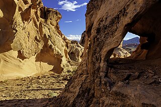
Gold Butte National Monument is a United States national monument located in Clark County, Nevada, northeast of Las Vegas and south of Mesquite and Bunkerville. The monument protects nearly 300,000 acres of desert landscapes featuring a wide array of natural and cultural resources, including rock art, sandstone towers, and important wildlife habitat for species including the Mojave Desert tortoise, bighorn sheep, and mountain lion. The area also protects historic ranching and mining sites such as the ghost town of Gold Butte, although little but mine openings, cement foundations, and a few pieces of rusting equipment remains. The monument is managed by the Bureau of Land Management.
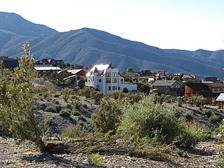
Cold Creek is an unincorporated community in Clark County, Nevada, United States located within the Spring Mountains National Recreation Area and approximately 28 miles by road from the Las Vegas city limits. Cold Creek is named for the stream that flows through the community.

Corn Creek is an unincorporated community in Clark County, Nevada, United States. The community is located along the former Las Vegas and Tonopah Railroad where it had a station. It is approximately 7.5 miles from the Las Vegas city limits by road and is situated south of the Desert National Wildlife Refuge border and bordered to the west, south, and east with the Tule Springs Fossil Beds National Monument.

Macks Peak is a 10,036-foot elevation (3,059 m) summit located in Clark County, Nevada, United States.


